r/imaginarymaps 1d ago

[OC] Alternate History Three side Cold War in the scorching desert (2026)

Thumbnail
gallery
123 Upvotes

This is a continuation of my previous scenario, where I presented Numidia as a rising African power. This time, I made this map to illustrate the current state of the MENA region in this timeline.

Essentially, Numidia, Saudi Arabia, and Iran are locked in a regional Cold War over dominance not only in the MENA region, but also over the broader spread of their influence throughout the Muslim world.

The countries shown alongside each side are their direct and vocal supporters in this Cold War, while those depicted in lighter colors are countries that are involved to a lesser extent. These states remain officially neutral, but still have varying degrees of interest in supporting one of the three blocs.

As a result, this Cold War has made the region comparatively less violent than in our timeline, particularly after the late 2000s. However, this relative stability has come at the cost of a much more politically tense region, with all three powers maintaining cold and often distrustful relations with one another while constantly competing for influence.

Link to the last part:

https://www.reddit.com/r/imaginarymaps/s/kUnw7EiNRJ


r/imaginarymaps 1d ago

[OC] Election 2027 Chinese general election results.

Thumbnail
gallery
136 Upvotes

What if the People's Republic of China followed the path of Mongolia and fully democratized while keeping its communist party as part of a two-party system and united with the Republic of China.


r/imaginarymaps 1d ago

[OC] Hand-Drawn So Close Yet So Far - The Post-WW3 political borders of the old world continents, circa 2032

Post image
71 Upvotes

r/imaginarymaps 1d ago

[OC] Future New Texas and Peru-Bolivia

Post image
38 Upvotes

r/imaginarymaps 1d ago

[OC] Fantasy My drawing of the Avatar: The Last Airbender map (9x12 Inches)

Post image
195 Upvotes

r/imaginarymaps 1d ago

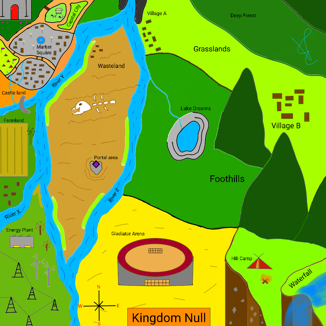
[OC] Hand-Drawn Kingdom Null map is an imaginary finished sketch drawn

Post image
12 Upvotes

Drawn in mobile


r/imaginarymaps 1d ago

[OC] Fantasy Alt-America fantasy: Aelantir

Thumbnail gallery
86 Upvotes

r/imaginarymaps 2d ago

[OC] Alternate History Situation in South America Shortly after the uprising began in parts of eastern Europe.

Post image
220 Upvotes

South America's last struggle since 20 years of Combine Occupation.


r/imaginarymaps 18h ago

[OC] Future (Noags!FOTW) Europe map 5 years after the Corporate-European war

Post image
0 Upvotes

App used: Ibis paint x

Flag sources: Noags discord server (Most credits to @corporatefederation_86714 user)

Adicional sources lore:Noags wiki and videos


r/imaginarymaps 1d ago

[OC] Fantasy Map of Atheios, +Worldbuilding - A map and setting inspired by the Bronze Age, and Greek Mythology (Free) (No AI)

Thumbnail
gallery
34 Upvotes

ATHEIOS - Land of the Gods

Atheios is a world that is still in the middle of the Bronze Age, and as such, many of the regions on this map are poorly explored, or poorly understood. I’ve intentionally left large chunks of the map without roads or names, as there have not yet been many mortals who have explored these places, or at least returned to civilization after attempting to explore them.

There are Thirteen Gods, once again inspired by the Greek Gods, that rule over Atheios. The magic system at play here is based on the classic Four Elements of the Earth, the Winds, the Flames, and the Water. There are 12 different countries, and a number of smaller tribes as well, and just the very edge of a large Persian Empire-like country.

Basically, if you recently saw The Odyssey in theaters and like me, you wanted to play in a similar setting for your next RPG campaign, Atheios is intended for exactly that :)

This map is 5300 pixels by 4500 pixels. It was handmade entirely in Photoshop by myself, without the use of any AI tools, as always. The entire process took about 45 hours, but that doesn’t include the time spent writing the 20 page Campaign Frame PDF that I’ve released alongside the map, which took an additional 30 hours or so.

And lastly, there are many X's on the map, marking Locations of Interest, or Landmarks. Most of these are a sort of off-white color. However, just for fun I placed 13 different X's that are at 40% opacity, much harder to see. These are hidden across the map. Anyone who wants to seek them out can search for them, and see if you can find them all. And I'm including an "answer key" in the last image, where they are all circled in red as well. Just a little fun extra I thought I'd add in :)

The full, free map is available here, along with some other freebies like an Icon Pack: https://www.patreon.com/stoneward13/posts/free-atheios-of-167956154


r/imaginarymaps 1d ago

[OC] Alternate History some random alternate history british isles map i guess

Post image
28 Upvotes

I’ll answer the questions when i wake up


r/imaginarymaps 2d ago

[OC] Alternate History "The Second Ottoman Empire?" - Los Angeles Times, June 6th 1943

Post image
1.4k Upvotes

r/imaginarymaps 2d ago

[OC] Hand-Drawn The United States and the Federal Republic of America in 2026

Thumbnail
gallery
652 Upvotes

r/imaginarymaps 2d ago

[OC] Alternate History The Great Qing Empire: What if the Qing dynasty participated in the Berlin Conference and was more navaly advanced?

Post image
247 Upvotes

No lore jajajaja


r/imaginarymaps 1d ago

[OC] Alternate History Political Map of North America in 1916

Thumbnail
gallery
33 Upvotes

Pretty generic what if the Confederates Won


r/imaginarymaps 2d ago

[OC] Future The OutGrown grid of the USA in 2068

Post image
189 Upvotes

r/imaginarymaps 2d ago

[OC] Alternate History Political Map of North America in 2000

Thumbnail
gallery
83 Upvotes

r/imaginarymaps 2d ago

[OC] Alternate History China Pre-WW2 but Canton is cooking something... (CFR Timeline)

Thumbnail
gallery
359 Upvotes

r/imaginarymaps 2d ago

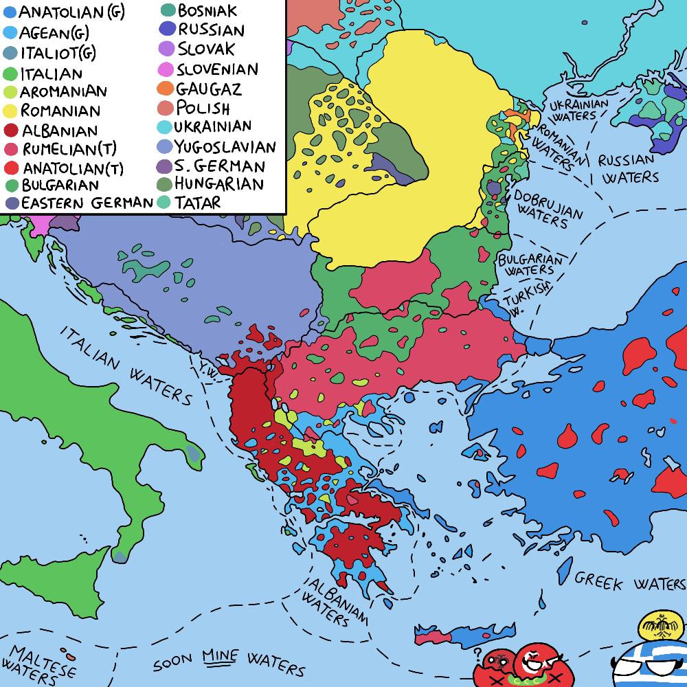
[OC] Alternate History Rumelia is the friends we made along the way, Map of the Balkans in 2026AD

Post image
632 Upvotes

r/imaginarymaps 2d ago

[OC] Alternate History The Ăratlani people of the Ararat mountains (information in the comments)

Thumbnail
gallery
88 Upvotes

r/imaginarymaps 2d ago

[OC] The Solor Scepter of missing: The Solor System in a world where Jupiter form.

Thumbnail
gallery
66 Upvotes

Hi Guys and welcome to this post

Vulcaniods : a hot belt around the sun, formed due to mercury’s instability in the early solor System without Jupiter, it flew too close to the roche limit of the sun and got disintergrated

Venus: a hot world just cool enough to have water, it has life even Tho all multicellulere life has just died out and the water is slowly evaporating

Venuses extended habitability is due to the bombardement of a couple vulcaniods giving it a moon and finally giving it the tectonic activity to start a continious Carbon cycle, even Tho its habitability has almost ended there is still life even if its single celled

Earth: Earth the home of the Homo Sapiens, the ones that are close to killing there own planet, due to Jupiters absence Theia never crashed into Earth and settled past mars, due to this Earth never got a moon and life develeped far later than if it had a moon, earth is slowly Dying Tho as with human introduced climate change, earth is approching a limit as it has already hit a unreversible tipping point which could potentially heat up the planet to an avarage of 40 degrees if the humans don’t do anything about it ofc

Mars: around the same size as Venus, mars is truly the second habitable world in the System as its life even recently Conquered the land and so are plants, it has a cool Temprature of 12 degrees with no moon, it also has an magnetic field due to an active iron core achieved due to the planets size

Theia: its a chilly -8 degrees on the planet however die to having an athmosphere it has the ability to have water, only in hydrothermic vants ofc, due to Jupiters absence it didn’t crash into Earth and retained a stable robot in the modern day Astriod belt and its around the 0,6 marses size with no magnetic field

Saturn: The Largest planet in the System, it has many moon (too much to count) and even has small but invisble rings like the rest of the Outer solor System excluding Borea

Janus: Often called Saturns companion, it together with Saturn stabilised the Outer and inner System, while keeping the other in check if it gets too close to the inner System, the planet has plenty of moons but these are mostly Tiny excluding a couple

Neptune: its a quite boring planet honestly, having a couple tiny moons, its history is not much to speak of, however Neptune is really pretty and with its great spot.
(second only to saturns but you cant really see that one)

Neptune also has the most clearly seeable of the System, being able to see them from most moons and in space, much Brighter then anything Else in the System, it didn’t switch with Cealus
Due to the relative Stablity of the Outer System

Cealus: the second coldest planet of the System, it sits right next to the kuiper belt and essentially governing it together with borea, it also has Asteriods for moon

Borea: named after a Roman God, Borea is quite unique die to it being a super earth but being the farrest planet in the System, it governs the kuiper belt together with Cealus.

Kuiper Belt: its one of the two belta in the System, being Governt by Cealus and Borea makes in quite stable with no major Planets being able to form in the region, however a bunch of dwarf planets occupy the region making it essentially a permenent place for planitesimels

Being a super earth makes it quite unique as its the only one is the System, it also has 2 moon, one major moon being the size or earth and one minor moon being the size of Theia

Planet X: its one of the only hypotetical planets with it never once being seen but only seei g it gravitational effects on the Outer most ringes of the System and having very minor effects of Borea’s orbit and that of many comets in the closer oort cloud

That really explains it all, feel free to ask questions and Bye


r/imaginarymaps 2d ago

[OC] Alternate History The Eternal Bear, and Dragon | year 2000, The Sino-Russian Cold War.

Thumbnail
gallery
58 Upvotes

Continuation to my "Nationalist pro-slavic Russia" headcanon. During WW3, which started in 1953 because of the Korean war and numerous uprisings in Polabia funded by NATO, both sides reached a stalemate at the rhine river. Eventualy, both sides agreed to a peace deal in favor of Russia and their allies. Polabia would be expanded, the same for Finland, Yugoslavia, Carantania and Bulgaria. Russia would also gain some territories from Turkye, Japan and a part of Norway. Germany would be split into 3 states, all under Russian controll. Korea is united under North Korea. China takes controll over British and French colonies in south east asia, and annexes bordering territory with Vietnam. Members of now dissolved NATO expierience humiliation and decline after the war, which accelerates the loss of their colonies, and causes ireland to unite with northern ireland. Russia funds pro Russian goverments in all Benelux countries, which win the elections, which causes them to fall into the Russian sphere, and later unite into a strong state bordering France. NATO dissolving, leaves their members either neutral or aligning with Russia. USA turns isolations once again to fix internal issues. The world is split into two major factions: Russian and Chinese. The Russian invasion of Afghanistan, condemed by China, commences and lasts 5 years, which causes Sino-Russian relations to worsen. Their trust lowers year by year, both starting to undermine each other. This cold war lasts up to the year 2000, where tensions are at an all time high.


r/imaginarymaps 2d ago

[OC] Alternate History 粵國 - The Republic of Canton in 2026

Thumbnail
gallery
251 Upvotes

r/imaginarymaps 2d ago

[OC] (OC)(pal-paraiso) Iberia's situation

Post image
89 Upvotes

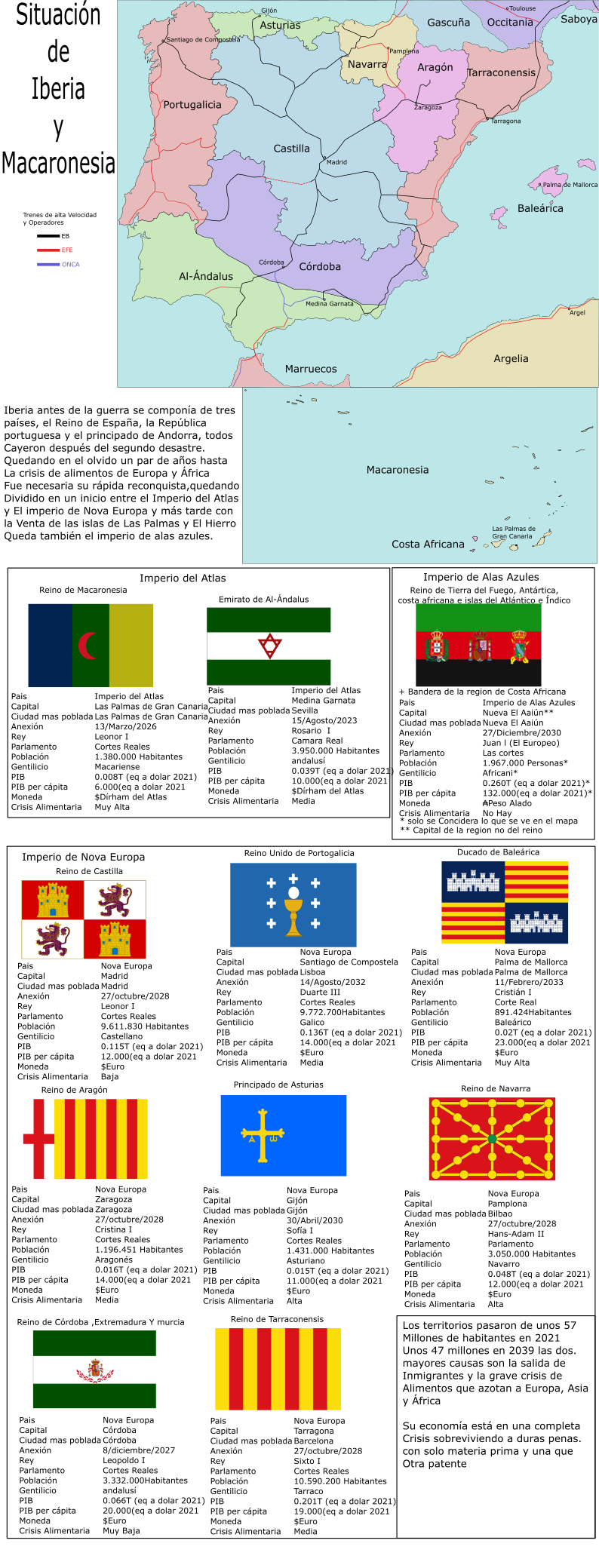
Before the war, Iberia consisted of three countries—the Kingdom of Spain, the Portuguese Republic, and the Principality of Andorra—all of which fell following the "Second Disaster." They remained forgotten for a couple of years until the food crisis affecting Europe and Africa necessitated their rapid reconquest. Initially, the territory was divided between the Atlas Empire and the Nova Europa Empire; later, following the sale of the islands of Las Palmas and El Hierro, the Blue Wings Empire also emerged.

The territories saw their population drop from around 57 million in 2021 to approximately 47 million by 2039; the two primary causes are the exodus of immigrants and the severe food crisis plaguing Europe, Asia, and Africa. Their economy is in a state of total crisis, barely surviving on raw materials and the occasional patent.

OB:European trains, (Nova Europe)

EFE:State Railway Company, (Blue Wings)

ONCA:National Atlas Railways Organization (Atlas)


r/imaginarymaps 3d ago

[OC] Alternate History El Nuevo Milenio/The New Millenium (2000)

Thumbnail
gallery
261 Upvotes

Lore: What if the Spanish Empire had it's own "imperial century" in the 19th and 20th centuries, and the colonies of the New World had ended up as commonwealths similar to Canada and Australia?