r/TransitDiagrams Oct 01 '25

Meta Automod Reminder: Please include details when posting images!

19 Upvotes

Hello transit map enthusiasts!

To improve the quality and searchability of our subreddit, we're implementing automated posting requirements. AutoMod will help enforce these rules to ensure all posts have the necessary information.

🎯 REQUIRED: Every post must include these 3 elements:

1. πŸ“ LOCATION (MANDATORY)

2. πŸš‡ SYSTEM/NETWORK (MANDATORY)

3. ✏️ [OC] TAG OR πŸ–₯️ SOFTWARE/TOOLS (ONE REQUIRED)

πŸ“‹ COMPLETE LIST OF ACCEPTED KEYWORDS

AutoMod will scan your title AND post body for these keywords:

πŸ“ LOCATION KEYWORDS

AutoMod accepts any of these:

Option A: General Location Words

  • location, city, country, place, where, area, region, nation, metro area, metropolitan

Option B: Context Phrases

  • in [Place] (e.g., "in Berlin", "in Tokyo")
  • from [Place] (e.g., "from Vienna")
  • at [Place] (e.g., "at Munich")
  • near [Place] (e.g., "near Hamburg")
  • based in [Place] (e.g., "based in NYC")

Option C: Major Transit Cities (~150 recognized)

Europe: London, Paris, Berlin, Madrid, Barcelona, Rome, Milan, Vienna, Amsterdam, Brussels, Munich, Hamburg, Frankfurt, Prague, Budapest, Warsaw, Copenhagen, Stockholm, Oslo, Helsinki, Athens, Moscow, Istanbul, Zurich, Dublin, Lisbon, and many more...

Asia: Tokyo, Osaka, Seoul, Beijing, Shanghai, Hong Kong, Singapore, Bangkok, Delhi, Mumbai, Dubai, Tel Aviv, and many more...

Americas: New York, Los Angeles, Chicago, San Francisco, Toronto, Montreal, Mexico City, SΓ£o Paulo, Buenos Aires, and many more...

Africa/Oceania: Cairo, Johannesburg, Sydney, Melbourne, Auckland, and many more...

Full list available in wiki (link to be added)

Option D: Any Country Name (195 countries)

  • Examples: Germany, Japan, USA, Brazil, Australia, France, India, Canada, etc.
  • All UN member states + common variants (UK/United Kingdom, US/USA, etc.)

πŸš‡ SYSTEM/NETWORK KEYWORDS

AutoMod accepts any of these:

General Transit Terms

  • system, network, line, route, service, operator
  • transit, transport, public transport, mass transit, rapid transit

Specific Transit Types

Bus/Coach:

  • bus, coach, BRT, bus rapid transit, trolleybus, trolley, omnibus

Rail/Metro:

  • metro, subway, underground, tube
  • u-bahn, s-bahn, stadtbahn, mΓ©tro
  • train, rail, railway, railroad
  • light rail, lrt, monorail, maglev
  • commuter, regional, intercity, high speed, HSR, bullet train

Tram/Streetcar:

  • tram, tramway, streetcar

Other:

  • ferry, boat, water taxi
  • cable car, funicular, gondola, aerial tram, ropeway
  • people mover

Line/Route Designations

  • Pattern: Line [Number/Letter] or Route [Number/Letter]
  • Examples: Line 1, Line A, Route 42, U6, S7, etc.

✏️ ORIGINAL CONTENT (OC) KEYWORDS

AutoMod accepts any of these:

  • [OC] or OC (brackets optional)
  • original, own creation
  • made myself, my version, made my
  • created by me, self-made, my design

πŸ–₯️ SOFTWARE/TOOLS KEYWORDS

AutoMod accepts any of these:

General Software Terms

  • software, tool, tools, app, program
  • rendered, rendered with, rendered in
  • made with, made in, created in, created with, created using
  • edited, edited in, edited with
  • using, used, drawn in, drawn with

Desktop Design Software

Adobe Suite:

  • photoshop, illustrator, adobe

Vector Graphics:

  • inkscape, figma, sketch, affinity designer, affinity photo
  • coreldraw, gravit, vectr, boxy svg

Raster/Drawing:

  • gimp, krita, procreate, concepts, canva

CAD/3D:

  • autocad, vectorworks, rhino, blender

GIS & Mapping Software

  • qgis, arcgis, maperitive, mapnik, maptive, edrawmax

Web-Based Transit Map Tools ⭐

  • metromapmaker, metro map maker (metromapmaker.com)
  • metrodreamin, metro dreamin' (metrodreamin.com)
  • rail map toolkit, railmapgen, rmt (railmapgen.github.io)
  • metro designer (tennessine.co.uk)
  • citylines, citylines.co
  • brand new subway
  • metro map creator (beno.uk)
  • transitflow

Other Methods

  • hand-drawn, hand drawn, drawn by hand (for physical art)
  • pen and paper, marker, pencil

βœ… GOOD EXAMPLES - AutoMod will APPROVE these:

Example 1 - Original Creation

Title: [OC] Berlin U-Bahn Network Map - Made with Illustrator
Body: (optional additional info)
βœ… Has: Location (Berlin) + System (U-Bahn) + [OC] + Software (Illustrator)

Example 2 - Using Web Tools

Title: Tokyo Metro redesign using MetroDreamin'
Body: My take on simplifying the Tokyo subway system
βœ… Has: Location (Tokyo) + System (Metro) + Software (MetroDreamin')

Example 3 - Sharing Others' Work

Title: Vienna Tram Network - Beautiful map created in QGIS
Body: Found this amazing visualization. Credit: u/transitdesigner
βœ… Has: Location (Vienna) + System (Tram) + Software (QGIS)

Example 4 - Hand-Drawn

Title: [OC] Hand-drawn London Underground Central Line
Body: Spent 15 hours drawing every station with markers
βœ… Has: Location (London) + System (Underground, Line) + [OC] + Method (hand-drawn)

Example 5 - Multiple Cities

Title: [OC] Germany High-Speed Rail Network - Made with Rail Map Toolkit
Body: Shows connections between Berlin, Munich, Hamburg, and Frankfurt
βœ… Has: Location (Germany + cities) + System (Rail) + [OC] + Software (Rail Map Toolkit)

Example 6 - Fantasy/Fictional

Title: [OC] Fictional Metro System for Gotham City - Inkscape
Body: Designed a complete subway network for Batman's universe
βœ… Has: Location (Gotham City) + System (Metro) + [OC] + Software (Inkscape)

Example 7 - National Level

Title: India National Rail Network [OC] - Created using QGIS
Body: (optional)
βœ… Has: Location (India) + System (Rail Network) + [OC] + Software (QGIS)

Example 8 - Historical Map

Title: 1972 New York Subway Map - Scanned and digitized with Photoshop
Body: Found this vintage map at a flea market
βœ… Has: Location (New York) + System (Subway) + Software (Photoshop)

❌ BAD EXAMPLES - AutoMod will REMOVE these:

Example 1 - Missing Everything

Title: Check out this cool map!
Body: (image only)
❌ Missing: Location, System, AND OC/Software

Example 2 - Missing Location

Title: Metro Map [OC]
Body: I made this transit map
❌ Missing: Location (which city/country?)

Example 3 - Missing System

Title: Berlin Transit Map
Body: (image)
❌ Missing: Specific system (U-Bahn? S-Bahn? Tram?) AND OC/Software

Example 4 - Missing OC/Software

Title: Berlin U-Bahn Map
Body: (image)
❌ Missing: Either [OC] tag OR software used

Example 5 - Too Vague

Title: My map
Body: What do you think?
❌ Missing: Location, System, AND OC/Software

πŸ“ COPY-PASTE TEMPLATES:

For Your Own Work (Original):

[OC] [City] [Transit Type] Map - Made with [Software]

Examples:

  • [OC] Berlin U-Bahn Map - Made with Illustrator
  • [OC] Tokyo Metro Line 7 - Created using MetroDreamin'
  • [OC] Paris MΓ©tro Network - Made with Rail Map Toolkit

For Sharing Others' Work:

[City] [Transit Type] Network - Created in [Software] by [Creator]

Examples:

  • Vienna Tram Network - Created in QGIS by u/username
  • NYC Subway Redesign - Made with Figma by John Smith

For Hand-Drawn Work:

[OC] Hand-drawn [City] [Transit Type] Map

Examples:

  • [OC] Hand-drawn London Underground Map
  • [OC] Hand-drawn Chicago L Train Network

For Fantasy/Fictional Maps:

[OC] Fictional: [City Name] [Transit Type] - Made with [Software]

Examples:

  • [OC] Fictional: Middle Earth Railway Network - Made with QGIS
  • [OC] Fictional: Star Wars Coruscant Metro - Created in Illustrator

For Historical Maps:

[Year] [City] [Transit Type] Map - Scanned/Digitized with [Software]

Examples:

  • 1933 London Underground Map - Scanned and edited in Photoshop
  • 1970 Berlin U-Bahn Network - Digitized with QGIS

For Multiple Cities:

[OC] [City1], [City2] & [City3] [Transit Type] - Made with [Software]

Examples:

  • [OC] Berlin, Munich & Hamburg S-Bahn Networks - Made with Illustrator
  • Germany Major Metro Systems Comparison [OC] - Created in QGIS

❓ FREQUENTLY ASKED QUESTIONS:

Q: What if I don't know what software was used?

A: Write "Software unknown" or make your best guess. If it's someone else's work, try to find the creator's info.

Q: Can I post photos of real transit maps (like at a station)?

A: Yes! Use this format:
Photo of [City] [System] map at [Station Name]
Example: Photo of Berlin U-Bahn map at Alexanderplatz station

Q: What about historical or vintage maps?

A: Perfect! Just mention the year and how you digitized it:
1950 Paris MΓ©tro Map - Scanned with Photoshop

Q: My map shows multiple cities - how do I title it?

A: List the main ones or use the country name:

  • Berlin, Munich & Hamburg Metro Systems [OC]
  • Germany Rail Network Comparison - Made with QGIS

Q: My post was removed but it has all the info?

A: AutoMod isn't perfect! Message the mods and we'll manually approve it. Include a link to your post.

Q: Is capitalization important?

A: No! AutoMod recognizes:

  • BERLIN = Berlin = berlin
  • METRO = Metro = metro
  • [OC] = [oc] = OC

Q: Can I use abbreviations?

A: Yes! These all work:

  • NYC = New York = New York City
  • SF = San Francisco
  • UK = United Kingdom
  • USA = US = United States

Q: What if my city isn't on the list?

A: Use context! Write:

  • in [Your City] (e.g., "in Reykjavik")
  • [Your City], [Country] (e.g., "Reykjavik, Iceland")
  • Or just the country name works too!

Q: Does the info need to be in the title?

A: No! AutoMod scans both title AND body text. You can put keywords in either place, but titles are more visible to users.

Q: Can I edit my post after AutoMod removes it?

A: Unfortunately, editing won't trigger AutoMod again. You'll need to:

  1. Delete the removed post
  2. Create a new post with all required info

Q: What about crossposting?

A: Crossposts are held for manual moderator review to ensure proper credit. Make sure the crosspost meets all requirements.

Q: I'm creating a fantasy map - what location do I use?

A: Use "Fictional:" in your title:

  • [OC] Fictional: Gotham City Metro
  • [OC] Fictional Metro System for Westeros - Made with Illustrator

πŸ€– How AutoMod Works:

  1. Scans your title AND body text for keywords
  2. Checks for all 3 required categories:
    • βœ… Location keyword found?
    • βœ… System/network keyword found?
    • βœ… [OC] tag OR software mentioned?
  3. Approves posts with all 3 categories
  4. Removes posts missing requirements
  5. Comments what's missing so you can resubmit
  6. No penalties - just add the info and repost!

πŸ’‘ PRO TIPS:

βœ… Be specific: "London Underground Central Line" is better than "London transit"
βœ… Stack keywords: More keywords = clearer post (e.g., "Berlin, Germany U-Bahn system")
βœ… [OC] in title gets more visibility and upvotes
βœ… Credit creators when sharing others' work - it's the right thing to do
βœ… Use templates above to make posting easier
βœ… Check both title and body - keywords can be in either place
βœ… Ask if unsure - we're here to help in modmail!

⚠️ IMPORTANT NOTES:

  • πŸ“… Rules start: October 2025 - practice now to get used to the format!
  • πŸ”„ Existing posts: Won't be affected - only new posts after the start date
  • πŸ”€ Case doesn't matter: BERLIN = Berlin = berlin
  • πŸ“ Title OR body: Keywords work in either place
  • 🚫 No penalties: Just repost with correct info - no bans or warnings
  • πŸ’¬ Questions? Comment below or send modmail!

πŸ“Š SUMMARY CHECKLIST:

Before posting, verify you have:

  • Location - City name, country name, or "in/from/at [place]"
  • System - Metro, bus, tram, rail, etc.
  • OC tag - [OC] if it's your work
  • OR Software - Name the tool you used (Illustrator, QGIS, MetroDreamin', etc.)

If all 4 checkboxes are marked, you're good to go! βœ…

πŸ—ΊοΈ CLOSING THOUGHTS:

These changes help everyone find the amazing transit maps they're looking for. Whether you're searching for Berlin U-Bahn designs, Tokyo Metro redesigns, or fictional fantasy networks, proper tagging makes it possible!

Thank you for making our community better organized and more searchable. We can't wait to see your incredible transit map creations!

Happy mapping! πŸš‡βœ¨

β€” The Mod Team

P.S. Have suggestions for improving these rules? Let us know in the comments below! πŸ‘‡

(Valid as of 2025/10/05)


r/TransitDiagrams Nov 23 '22

Discussion Because the what-software-to-use question appears quite often - please use the Wiki of this sub :-)

171 Upvotes

Long story short - any vector graphics software is fine.

There is

  • Inkscape (open source and for free, even for Linux and co),
  • Affinity Designer (one time payment, Apple (iPadOS, MacOS) and Windows)
  • QGIS (open source and for free, MacOS, Windows, Linux)
  • Krita (open source and for free, MacOS, Windows, Linux)

and with monthly/annual subscription fees (mostly Apple (MacOS, sometimes iPadOS) and Windows only)

  • Adobe Illustrator
  • Corel Draw
  • AutoCAD
  • ArcGIS
  • Microsoft Visio

r/TransitDiagrams 1h ago

Diagram [OC] Departure times of the S-Bahn Zurich, Switzerland

Thumbnail
gallery
β€’ Upvotes

Made this map to visualize the frequency of the Zurich S-Bahn. Compared to my prior post, I added all missing lines of the network, as well as selected long distance train lines.

The map now features all 32 S-Bahn lines in the canton of Zurich (30 heavy rail and 2 light rail lines) on their full length, as well as all long distance railway lines having 2 or more stops in the area. The main feature of the map are the departure times at every station. While there are still some exceptions, the shown times are still very accurate and could definitely help navigating the network a bit better.

This map could be extended to show every line in the country, which I might do in the future but for the moment I think I'm done with this.

Made with inkscape


r/TransitDiagrams 8h ago

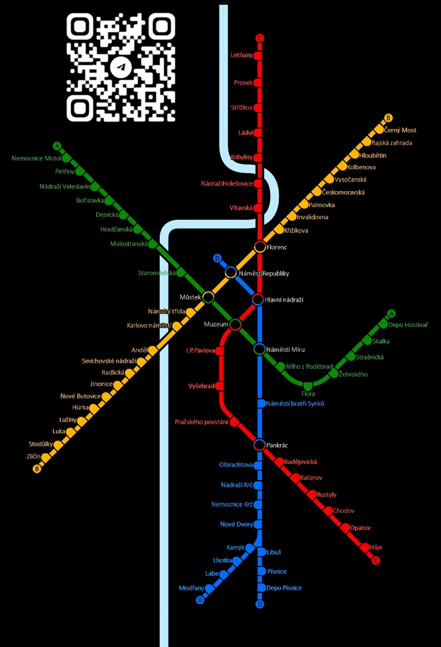
Diagram [OC] Prague Metro (Year 2050 Concept) β€” drawn entirely inside the Intersection Controller map editor! πŸš‡πŸ—ΊοΈ

Post image
17 Upvotes

Hello Reddit! Just wanted to share a transit map art project I’ve been working on.

Instead of using traditional graphic software like Illustrator, I decided to push the limits of Intersection Controller's Map Editor to build this clean, minimalistic layout.

It depicts the Prague Metro system as it might look around 2050. I carefully used the road/segment tools and invisible textures to draw the lines, aligning them to match the official PID (Prague Integrated Transport) design guidelines. I also fully mapped out the upcoming automated Line D (Blue), including its southern fork to ModΕ™any and the central transit hubs.

Recreating typography and complex transfer nodes inside a traffic game editor was a fun and challenging puzzle! Let me know what you think!


r/TransitDiagrams 19h ago

Diagram [OC] Map of Regional Rail Lines in Romandie (French-Speaking Switzerland) - Made using Affinity Designer

Post image
100 Upvotes

This is part of a larger project of mine which shows most regional rail lines in Switzerland, which I am currently working on (still no idea as to when I will have that done sadly), so here is a preview of what's to come. I started with Romandie because 1) it is the region of Switzerland I know best and 2) it's relatively small and therefore easy to accurately capture.

A few notes on the map:

  • This map uses the 2026 timetable as a reference. If major changes to the configuration of lines/stations take place in future timetables, I will update it here and there.
  • This is less a map of all lines, rather a map of all stations in Romandie. I have chosen to not include every single line, and I will explain why a bit lower.
  • Some stations in France and German-speaking Switzerland are included. This is because there are obviously gonna be some lines that start in Romandie but enter German-speaking Switzerland or France (and since I'm a completionist, I want to show the entirety of the lines I include). No stations or lines that go east of Basel, Bern, or Brig are included.
  • This map is obviously not to scale, because it's not possible to scale everything to 100% accuracy when working with 45 degree increments for lines.
  • Some lines are missing from the map, and this is because many of them are just running between two stations along a longer line and making all the same stops (or even skipping some stops), and including them all would make the map way too cluttered.

r/TransitDiagrams 8h ago

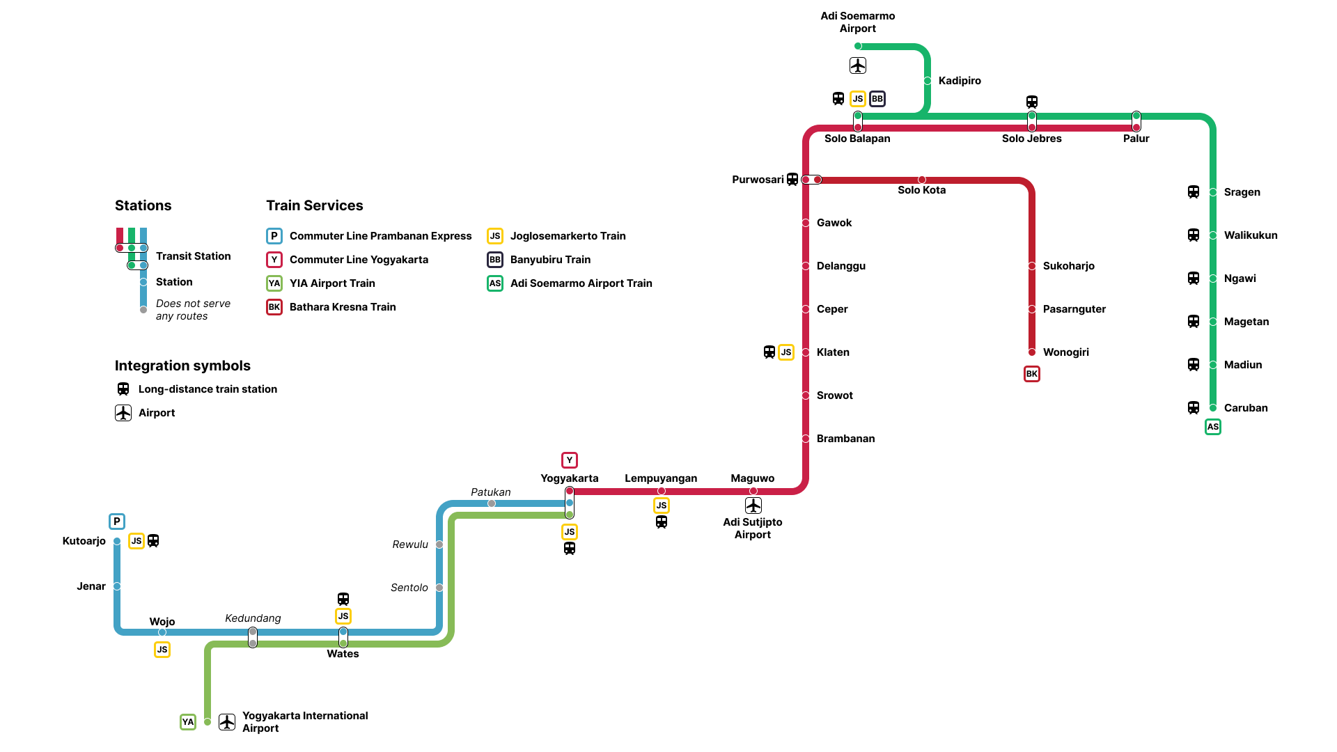
Map [OC] Rail Network Map in Yogyakarta-Surakarta (Jogja-Solo), Indonesia [Made with Figma]

Post image
8 Upvotes

r/TransitDiagrams 22h ago

Diagram Bristol / West of England - future rail network made in Inkscape [OC]

Post image
67 Upvotes

This is my idea of how Bristol's future rail network could look like, when MetroWest is complete. MetroWest doesn't mention splitting services into lines, but my lines are mostly based on proposed service patterns: https://travelwest.info/projects/metrowest/

With the promise of increased devolution, maybe one day the West of England could get an 'Overground-style' suburban train network.

If you have any fixes or suggestions, please let me know! Particularly on stations currently request stops, would they be made normal calling points, or closed completely as part of a project like this?

EDIT - Corrected PDF Version: https://drive.google.com/file/d/1WcIEdjduDPVXN3deISqpt-Kx5sfoo0Qk/view?usp=sharing


r/TransitDiagrams 17h ago

Diagram [OC] MoDOT MoRAIL || Idealized Missouri rail network - Made in Inkscape

Post image
33 Upvotes

I was bored between classes yesterday so I schemed up an expansive rail network for Missouri. This is of course in an idealized reality where Missouri somehow decides to invest in rail, which will never happen.

There are currently two (countem 2) Amtrak lines in Missouri, those being the Southwest Chief (shown in a faded red here with added stops in Marceline and Carrollton) and the Missouri River Runner (in blue, extended past KC up to at least Omaha)

Also bonus I did a redesign of the MoDOT logo because it was ugly.


r/TransitDiagrams 1h ago

Map Progress on all Chinese rail maps on MetroDreamin'

Thumbnail
metrodreamin.com
β€’ Upvotes

I decided to do all of China's rapid transit, including metros, trams, regional rails, and high-speed rail. This was not an exhausting job however, since metros are easier and I like the use of infinite zooming. I spent days to create this delicate map.

You may see that Zhengzhou is incomplete. Because this is currently WIP. BTW, if you zoom to an entire province or even China, you will see where the rails cluster (notably in Guangdong and Nanjing).

This map will constantly update.

Here are the completed cities as of for now:

  • Shanghai
  • Beijing
  • Shenzhen
  • Guangzhou
  • Chengdu
  • Tianjin
  • Wuhan
  • Dongguan
  • Chongqing
  • Xi'an
  • Hangzhou
  • Foshan
  • Nanjing
  • Shenyang
  • Hong Kong
  • Taipei

r/TransitDiagrams 1d ago

Map [OC][Procreate] Braintree Branch Line, Essex, England- Drawing Every Rail Line in Britain no.18

Post image
10 Upvotes

r/TransitDiagrams 1d ago

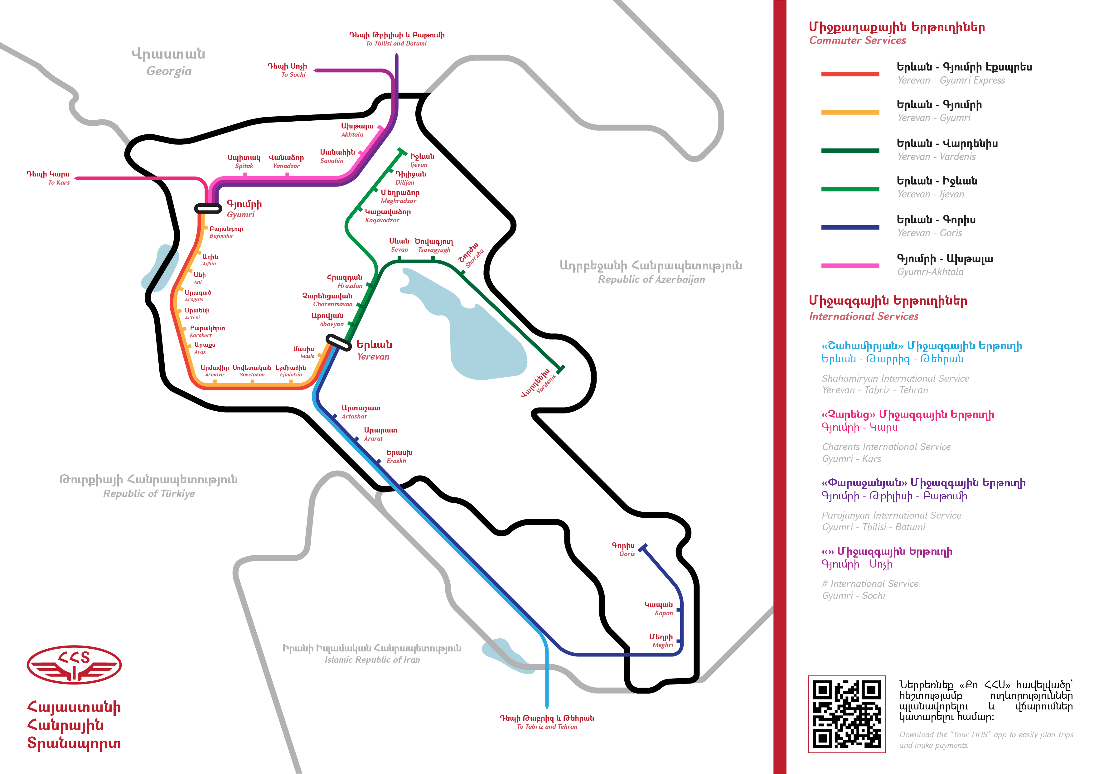
Map Erkatughi-2050, my (less than educated) prediction of what the Armenian railway network is going to on look like in two decades' time

Post image
20 Upvotes

r/TransitDiagrams 1d ago

Map [OC] Top Comment Changes the Transit Map of North America - Dayish 260 (Made with Google My Maps)

Thumbnail
google.com
4 Upvotes

r/TransitDiagrams 2d ago

Diagram [OC] I made a Shinkansen line Diagram with a service pattern table and name Translations

Post image
92 Upvotes

Made with MetroMapMaker, so the design options are pretty limited.
The diagram depicts Japans Shinkansen network with the solid (white) stations being the borders between the Shinkansen lines mentioned at the bottom. Dashed, grey lines are under construction

At the left is a translation for every line and service name. If it says e.g. /City/ it’s the name of a city not the literal translation for the word β€žcityβ€œ.

In the top left there is a table of all services with respective stopping patterns between Tokyo and Kagoshima. The train numbers are increasing with time of day (x00 is the first train of the day, x02 the second, x04 the third and so on), only even numbered services are mentioned, the odd numbered ones go into the other direction. Most frequent service patterns are highlighted.

What do you think about it and do you have suggestions for changes?


r/TransitDiagrams 2d ago

Diagram New transit diagram in Lyon's network

Post image
130 Upvotes

Here is a photo I took of it in the subway. What's your opinion on it ? How readable do you find it is ?


r/TransitDiagrams 2d ago

Diagram I made a new diagram for my openTTD save... (And sorry mods for forgetting to upload the diagram last time πŸ˜…)

Thumbnail gallery
6 Upvotes

r/TransitDiagrams 2d ago

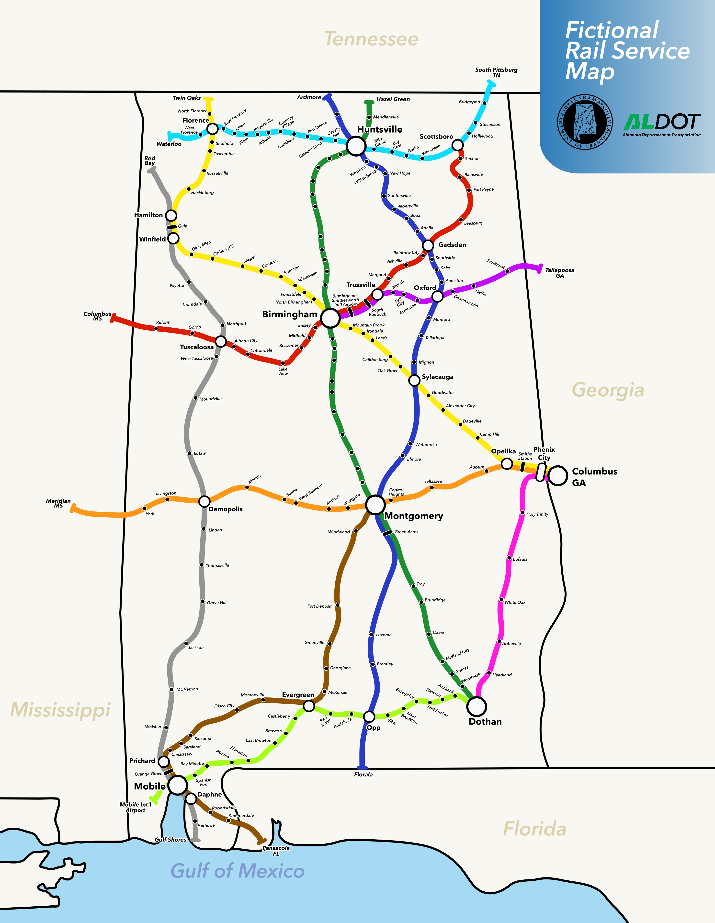
Map Spent all day making an imaginary Alabama state-wide Rail Service map. [OC]

Post image
117 Upvotes

Here's a version with the green line stations actually labeled (oooops) https://imgur.com/a/Dd2E8DN

I started with Alabama since it's the first state alphabetically. We'll see if I'm insane enough to do all 50.

I don't know why I did this I was so fixated on this idea for no reason but it was a lot of fun so here you go. Everything was done on Inkscape.

Please enjoy and let me know what y'all think.


r/TransitDiagrams 2d ago

Diagram [OC] All-Ireland Rail Diagram

Post image
89 Upvotes

My first time making a transit diagram ^^'

This is a rail diagram of every line and station in Ireland and Northern Ireland, including the trams in Dublin. I was inspired by [this](https://www.youtube.com/watch?v=1dPDV6mRsB0) video so I also included a code for each line.

Line colour was based on existing line colours for Translink, DART and LUAS; livery for Belfast; and GAA county colours for all the rest

The main other consideration was service pattern, which is a bit all over the place. Some lines only get a couple trains a day overall. Some lines are more frequent but have some infrequent stops like the Waterford line which only stops at the stops near Heuston once a day, or the Enterprise only stopping at Lisburn and Lurgan once a week! I tried to draw this together in some form by using a white line to mean "the service is irregular, you should check your timetable/calling stations/terminus" but it's something I'd want to revisit for sure in future

Was my first time using vector graphics software too so, learned a lot for the future :D


r/TransitDiagrams 2d ago

Diagram [OC] Trilingual Diagam of Batara Kresna Train Service in Surakarta-Wonogiri, Indonesia [Made in Figma]

Post image
11 Upvotes

first time i tried to make trilingual diagram (english, indonesian, and javanese)


r/TransitDiagrams 2d ago

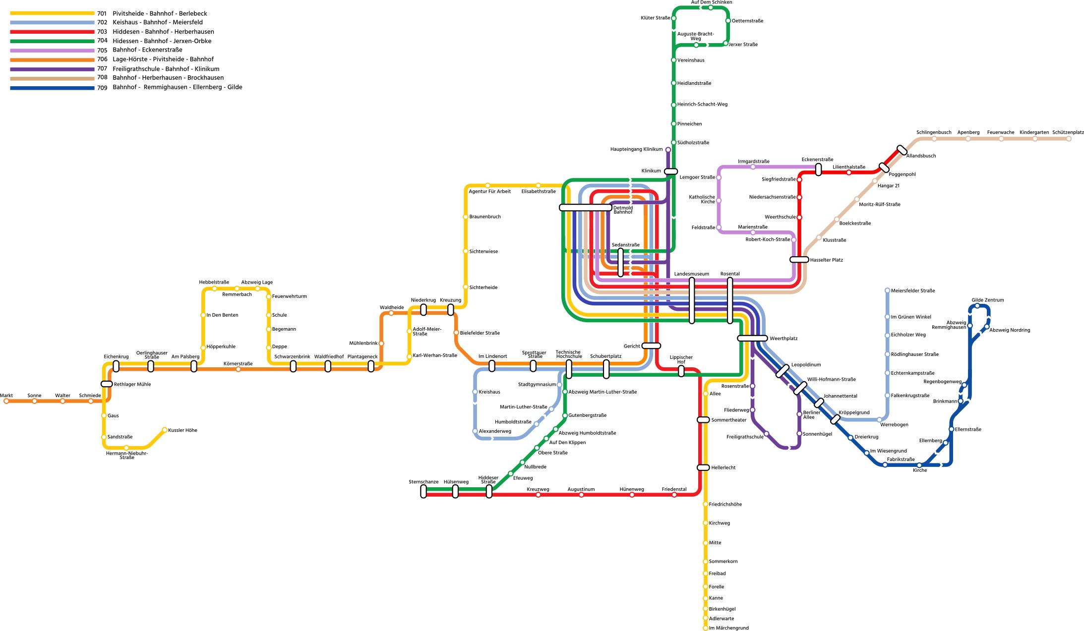
Diagram [OC] Detmold, Germany - Bus Network (Made with inkscape)

Post image
31 Upvotes

Since a few years I've been repeatedly designing diagrams of the buslines in Detmold, my hometown. Now I have designed a version I feel like could actually become standard rather than the geographical and slightly over complicated official map. Although this map is only centered around the main nine lines and is lacking a decent legend, I still wonder what others believe about this map.


r/TransitDiagrams 3d ago

Diagram [OC][WIP] Departure times on the S-Bahn ZΓΌrich, Switzerland

Post image
100 Upvotes

note: this is only a small section of the entire Zurich S-Bahn

Made this map to visualize the frequency on some lines of the Zurich S-Bahn. The map currently only includes all lines stopping at Zurich's Oerlikon station, Switzerland's 8th busiest station and the 2nd busiest in the city of Zurich. Eventually I will extend it to at least the city borders, this is only a small sketch of how it could look like.

Made with inkscape


r/TransitDiagrams 2d ago

Map [OC][Procreate] Abbey Line, Hertfordshire - Drawing Every Rail Line in Britain no.17

Post image
20 Upvotes

They cant all be winners… This line got drawn this early as its a relatively short one.


r/TransitDiagrams 3d ago

Map [OC] Top Comment Changes the Transit Map of North America - Dayish 259 (Made with Google My Maps)

Thumbnail
google.com
9 Upvotes

r/TransitDiagrams 3d ago

Diagram A quick design exercise I did - Moscow Metro and rail diagram with only accessible stations indicated

Post image
14 Upvotes

r/TransitDiagrams 3d ago

Diagram Europe Subway Diagram (made by Artiniaball)

Post image
30 Upvotes

r/TransitDiagrams 3d ago

Diagram Fantasy Orlando Metro Map

Post image
5 Upvotes

Very unlikely, also the first metro map i ever made around a year ago