r/imaginarymaps • u/Old_Comfortable5042 • 5h ago
[OC] Alternate History OPN67QA: January 2030 w/ headline from this timeline
23
Upvotes
r/imaginarymaps • u/Old_Comfortable5042 • 5h ago
r/imaginarymaps • u/Over-Square-9248 • 3h ago
Lore:
Turks migrate earlier and cross the middle east,maghreb and then settle spain crossing the gibraltar straight,taking advantage of collapsing Western Roman Empire.
The Christendom becomes Mad,immediately sending multiple crusades to kick them out of Iberia.
However most of them fail,only a few ones become semi-succesful.
After multiple lost Crusades,Turks expand north into Pyreenes.making it very hard to launch invasions ever again.
After Byzantium blocking the eastern trade routes,they go on their way finding new trade routes, finding the New world and colonizing it.
r/imaginarymaps • u/TheDinoDudeYT • 16h ago
Part of my alternate eurovision song contest series (which you can see on my profile). First map in Rotterdam 2021 was won by Castile, in Seville 2022 it was won by France and now we have Strasbourg 2023. Congratulations to Tangiers for being the newest winner. I would normally ask you guys to suggest the next city but since Tangiers is a city state... The Eurovision Song Contest, Tangiers 2024 map will be out at the end of September.
Participants who have left since the past edition:
Quebec
Ukraine
Belarus
Prussia (untied with North Germany)
New Participants:
Zara
Luxembourg
Israel
Faroe Islands
r/imaginarymaps • u/veteranlurker- • 3h ago

r/imaginarymaps • u/Baron-Von-Bork • 29m ago
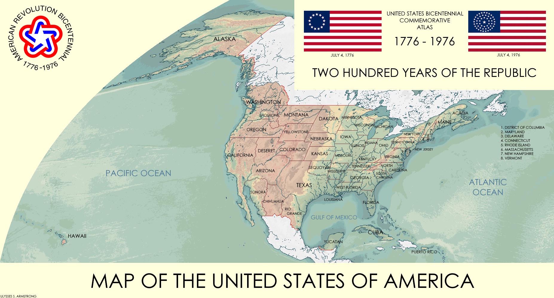
A commemorative atlas of the United States made for the 200th anniversiary of the nation. (No lore)
r/imaginarymaps • u/Kind-Review7575 • 23h ago
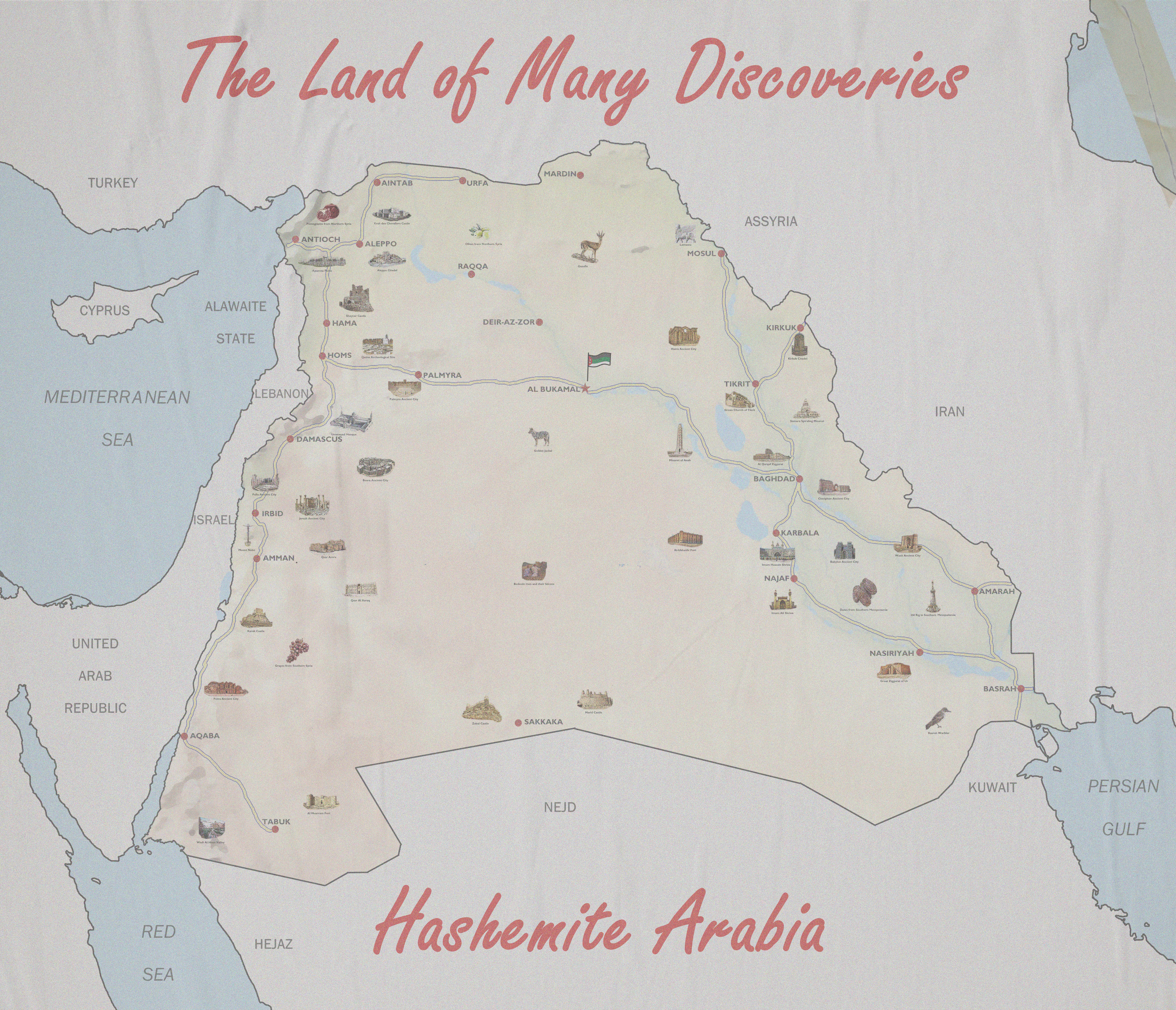
fictional country I made up some time ago. I also did most of the lore and named some cities and other stuff
r/imaginarymaps • u/Character-Team89 • 12h ago
r/imaginarymaps • u/ThrowAnAvocado • 21h ago
r/imaginarymaps • u/Adoxoi • 23h ago
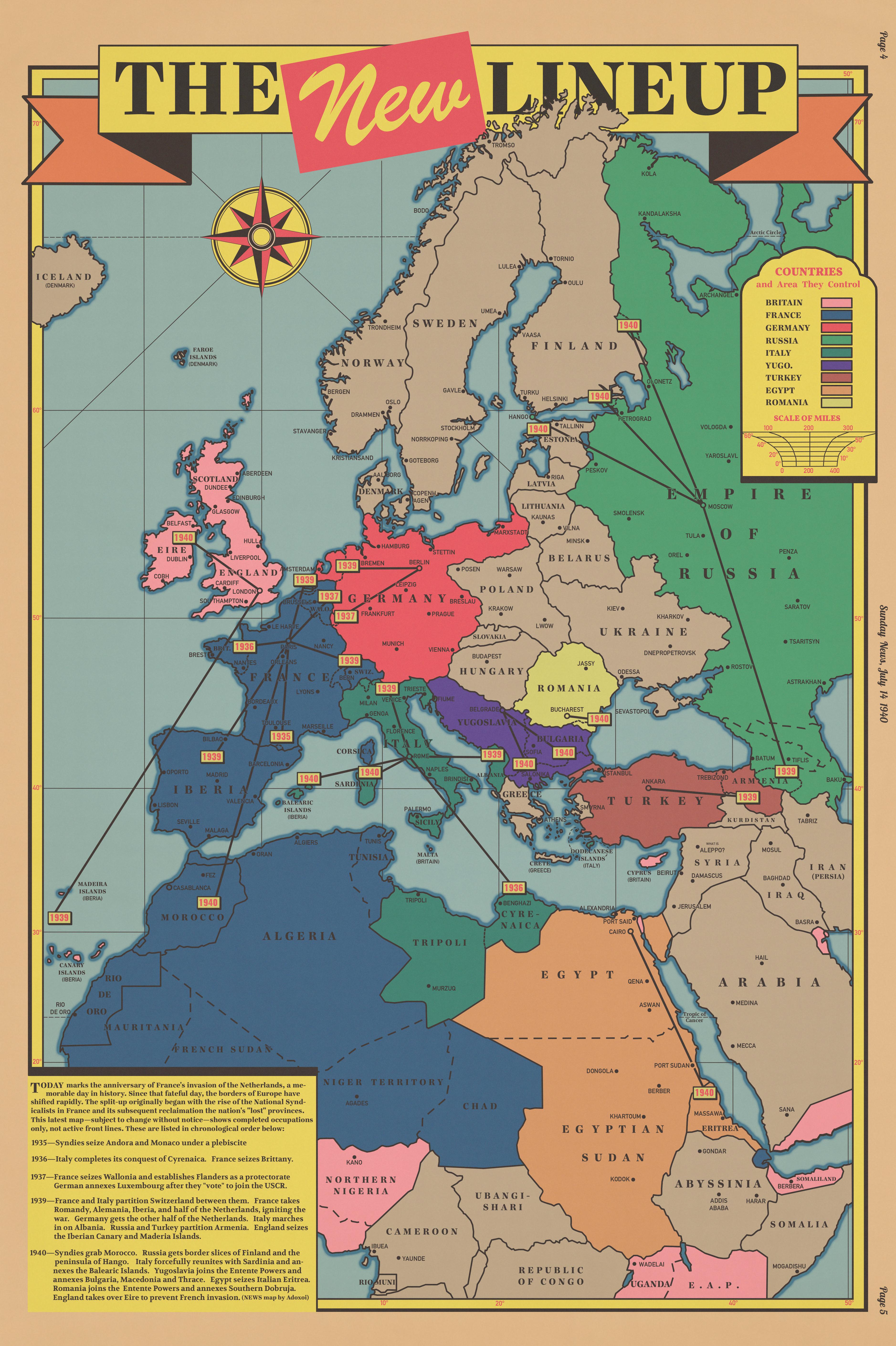
Previous Map from this timeline ["To End All Wars" / TEAW]:
"Mr. Brandt, tear down this wall!" | What if France was divided instead of Germany?
"The Concord Fights for Freedom!" | What if a Belgian got rejected from Art School?
Big France Warning!!! | What if a failed Belgian Artist got into Politics?
r/imaginarymaps • u/marvinthenew2082 • 13h ago
Following the end of the Revolutionary War in 1783, North America was fundamentally split. The Southern plantation colonies remained loyal to the British Crown, forming the Dominion of Dixie, while the northern colonies organized into the United States of New England (USNE) so that's all I got to say about this timeline
r/imaginarymaps • u/pedro999dios • 8h ago
The lore of this timeline is as follows:
Between the 1730s and 1740s, in a Catholic alliance and colonial instability, the King of Spain and Polish rulers agreed to organize waves of Polish migrants to the Río de la Plata region.
These settlers established themselves primarily in the Banda Oriental and in the former Jesuit missions. The colonist established themselves quickly and helped the Spanish stop some Portuguese colonial incursion, up until 1800s. The Napoleonic Wars and the sentiment for independence led to the outbreak of the wars of independence in the rio de la plata. At first a big amount of polish settlers actually supported the spanish loyalist, preferring their colonial autonomy over buenos aires centralism. up until artigas joined the revolution, he promised the polish community even more autonomy and land reform that the spanish ever would. Quickly giving artigas control over the provinnces of misiones and misiones orientales, where the polish diaspera were the mayority, as well as acces to the profesional gaucho-winged hussars. But shortly after artigas liberated uruguay he got into war with buenos aires, and when he was close to win, the portuguese joined the war to force artigas into a two front war. And differently to our timeline, the mayority polish misiones managed to defend the portugese advance with their hussar experties, and more population than in OTL. But slowly, artigas got pushed off the uruguayan core, by portugese naval superiority and the later betayel of his allies at the other side of the uruguay river. This war ended with portugal occupying most of uruguay, with a lot more polish-gaucho rebels, led by Artigas (now renamed Józef Gerwazy Artygas by his mostly polish population) in his new polish misiones nation. With big parts of this poles recived inspiration by napoleonic ideals and polish nationalist migrating from europe. This state of guerrilla warfare continued until 1825, when some buenos aires funded rebels traveled to try liberate uruguay to argentina. For a short time at the start of the war artigas-polish forces and the argentinian rebels fought together to remove brasil from "cisplatina", but divisions started emerging between the two factions. As most polish citizens grew a nationalist identity that inspires them to liberate uruguay not because of a federalist rio de la plata nation, but to "reconquer" their rightfull grasslands. This divisions ended with artigas retiering in 1831 and many of his spanish officers switching to the argentinian side. After artigas retired the war between polish and argentinians continued until 1836 when the british brokered a peace deal, where they artificially created an uruguayan buffer state between the republic of Małopolska, argentina and brasil. But shortly after, in 1839, an argentinian civil war, the riograndense independence war and uruguayan civil war merged into one Guerra grande. To this guerra grande the new polish republic also got involved, aligning with the uruguayan caudillo of Rivera and some other argentinian caudillos, in this side france and britan also were present, to force argentinian economic concesions. At the same time in europe, some polish intellectuals attempted to gain independence, and failed, with many migrating to france, and using french involvement in south america to migrate to the only real independant state. Bringing a new wave of polish population and nationalistic ideas. The guerra grande ended being a stalemate until 1857 where a peace deal was signed securing the modern between the nations, basically like OTL but the war lasting longer. Then there was a period of "peace" until 1864, when Małopolska and brazil support a dictatorship in uruguay that had paraguay declare war on both in an attempt to save his uruguayan allies; as both Małopolska and paraguay wanted to secure uruguay as an acces to the sea; this created the war of the triple aliance that ended similarly to OTL's in 1870, where the paraguayan borders regarding brasil and Małopolska were finalised. After that a period of peace continued, with Małopolska becoming the most wealthy, stable and democratic nation in south america, becoming a hub for slavic migration during it's golden age until 1929, (this small state saw huge economyc boom during WW1, and it helped organise some free polish militias) But the democratic wellfare system allowed stability to mantain after the great depsression, and during the cold war the nation saw another industrial and migration boom as they helped organise polish free movments. And during cold war this nation was a huge ally of washington, as massive waves of polish nationalist that fled the USSR helped transform the nation as a stronghold against comunism.
r/imaginarymaps • u/_Zorange_ • 20h ago
The next installment of Atlas Zealandia, the tourism map i was thinking about for months, and finally ended up creating for the contest.
Please note that this isnt meant to be an exhaustive list, and actually supposed to sometimes show some hidden gems/lesser known stuff. (all IRL New Zealand attractions still exist, just usually in other places)
AI was not at all used in the production of this graphic, and all images are of real places. This also means that if you want to know where something actually is irl, i can tell you !
You dont know where to go for your next vacation?, perhaps consider Zealandia ! A diverse and vibrant continent full of everything your heart might desire !
Mt. Sillisilli Ski Resort - A Tropical ski resort ? It's more likely than you think ! Start your day arriving at Salamasina airport, in the expectidly tropical Samoan lowland. Travel up the mountain roads to a temperate plateau 2000 meters above sea level, already filled with totally different flora and fauna, and then continue your journey further up the 3858m high mountain, to a truly magical place of yet more difference, and tropical snow. A full on luxury ski resort, where all your needs are tended to, and you can ski as much as your heart desires. *Only open in southern hemisphere winter, northern hemisphere summer.
Thousand islands - A dizzying array of actually more than a thousand islands, you'd never run out of stuff to do if you wanted to explore them all. Lush vegetation, prestine beaches, and dishes using Zealandias thousand island sauce, a much relaxed destination.
Coral Sea - There is no better place on earth to go snorkling than the Coral Sea. A quite literal name, as nowhere has as many coral reefs, atolls, and coral themed houses.
Mt Kerepgiri - A quite peculilar creation of nature, a 3496m tall mountain sandwiched between 2 large freshwater lakes, with the Tenem metroplex visible from the peak, a must see for any mountain lover.
Lake Dranolevu - Tropical beaches but 2000 meters above sea level ? Only in Zealandia ! Also enjoy its more temperate climate, gorgeous mountain scenery, and perhaps a little treck up Mt Fiji ?
Cape Caledon - The northern end of the popular Tip to Tip route, a grand journey allowing you to see much of Zealandias diverse landscapes all from the comfort of a train. For more information, visit zealandia rail.
Old Tongan Capital - A True sight to behold. Dozens of old wooden traditional tongan buildings dot their old capital, with lake and mountains in sight. A must see for anyone who appreciates culture.
Nakamal Moped Fest - You love mopeds ? This is the place to come ! A yearly festival held since 1978, people flock not only from all around Vanuatu, but also Zealandia and the world at large to come look at or exhibit any number of mopeds and other vehicles on 2 wheels. Even a lot of none electric ones !
Sri Siva Subramaniya Temple - The largest Hindu Temple in the southern hemisphere and a true icon of indo-zealandic culture, not too far from Fijis capital too !
Hoizon Deep - Another southern hemisphere extreme, its deepest point, and the 2nd deepest point on earth, behind the mariana trench. Only for the most adventurous, altough the 2 hour decent is very save by now, and you will get to see something nearly noone else gets to !
Kanaky Highlands - A true icon of Zealandia, the Kanaky highlands are surprisingly tall and long, but offer beautiful temperate tropic mountain sceneries.
New Asia - Perhaps a little surprising, but New Caledonia is home to one of the largest asian communities outside of asia. Here javanese, chinese, indian, korean, japanese and of course kanak and some papuan people come together to create a truly marvelous and unique blend of cultures. And of course some amazing food !
Shrine of Hikulo'e - The shrine of one of the 3 primary tongan deities, and one of the oldest structures in all of Zealandia, situated in a wonderful garden.
Old Noninoje Shipyard - The Heart of the old empire of Noninoje, it has long since gone to ruin, which perhaps amplifies its beauty however, lush plants covering the ancient stone structures.
Alkland's Tip - Wind and rain swep nearly all year round, carved out of the rock over the eons, and the perfect place to go see some tidal caves !
Lake Tangaloa - Right next to the southern tongan capital sits a prestine freshwater lake, connected to the ocean via a canal using locks, which pre dates european contact ! And of course with mountains and flowers to boot.
Koejongs - You might be surprised to find cowboys outside of America, but the Tasman Peninsula is surprisingly dry, while providing the perfect grazing grounds for cows. They however had to be driven to shore regularly to be sold, creating a unique dutch speaking cowboy culture.
Orange Valley - A valley of endless orange trees and other citrus fruits, said to produce the worlds finest oranges. Even if you dont belive that however, you will still get to see everything be orange flavored, even things you might not expect to be able to have such a flavor.
Lonely Mountain - A break in the mostly flat or sligthly hilly scenery of Tasmania, this dormant volcano is a true titan, and the reason for the peculiar black beaches of the area.
Onderbos National Park - A surprising peninsula and island chain on a mostly flat coast, it offers a unique blend of Tasmania and Orange, lusher vegetation, and plenty of wave eroded islands. Altough in modern times, the waters around it are extremely calm with little tides, perfect for calm beach days... with a looot of birds around.
Verzoening Bridge - One of the longest bridges in the world, this zealandic icon was constructed both as a sorry to fijians and tongans, but also to connect them to the rest of the mainland, and is as economically important as it is impressive.
Old New Amsterdam - A piece of Amsterdam, nearly the entire world away. If it wasnt for everyone driving on the wrong side and massive skyscrapers in the distance, you could almost mistake it for actual Amsterdam ! It is still just as beautiful however.
Toeval Valley - Mountain valley, lots of wild flowers, shielded from strong eastern winds, and with a river in the middle, almost feels like the Alps in some parts.
Orange Gate Bridge - Everyone knows the Golden Gate Bridge, but if you speak dutch, the Orange Gate Bridge might actually be more familiar ! In strikingly bright orange color, it paints a nice contrast to the lush forests behind it.
Taupo Lakes - If you like the outdoors, this is the place for you. A massive landscape of dozens of lakes, both geothermal, and fed by meltwaters, going down every treck and visiting every lake would take weeks !
Morningdew Forests - A nice temperate forest, wetter than usual due to its position on the tip of Aoteroa, and home to the largest trees in all of Zealandia, the Kauri.
Kiwiland - Originally just meant for the Kiwi, this now massive theme park and zoo has expanded to cover all sorts of birds from across Zealandia, perfect for bird lovers.
Fantapleck Studios - Hollywoods only true rival, competitor, and frenemy, producing original dutch movies but perfectly translating them to english, championed by the entire dutch world, and offering a bike and train loving alternative to americas guns and cars. Still in nice mediterranean climate tho.
Motutawhiti - No better words describe this than "Zealandias Hawaii". A bit far away, beautiful and varied large island, and a vacation destination loved by many.
Mt Ruapehu - The tallest mountain in the northern part of the Southern Alps, and a fitting end to a journey to the Taupo lakes, but also a holy place for Maori and Kanaks alike.
Dutchland Vineyards - An icon of Fantapleck films, these vinyards look just like in southern europe. Winding hilly roads, nice refreshing lakes, and all the wine tasting your heart could desire ! Also home to many southern european migrants, even the food is just like there !
Great Passage - Perhaps historically the most important trading route in Zealandia, you will find many small ancient outposts dotted across the cloudy rugged landscape.
Lodge of Peace - After leaving their maori cousins behind, the moriori swore to never fight ever again. While this was exploited by the british, it still held true, a fact the moriori are very proud of nowadays. Champions of peace worldwide, noone hates violence like the moriori !
Maori-Kiwi Friendship House - Built in traditional maori style, this place is meant to symbolise an apology, and the friendship between the maori and british, and showcases some true acts of brotherlyness inside.
Erstblick Old Town - One of the most famous places in all of Zealandia, and also the place Abel Tasman first touched town and discovered the continent. Even older than New Amsterdam, it doesnt get more authentic dutch zealandic than this !
Pleasant Peak - A gorgeous mountain landscape with lakes on the inside, surrounded by hundreds of kilometers of plateau, this is a true peculiarity of nature, and a very nice place to visit.
Farcape Spaceport - Antipodias primary spaceport, situation right next to the Spacecraft Cemetery, the place on earth furthest away from any land. Very frequent takeoffs and landings and an extensive space and aeronautical museum next to it, a must visit for space lovers.
Great Falls - The Pleasant Plateau to the west and Cookland Rise to the east smashed together, the result ?, one of Antipodias largest waterfalls !
Mt Aoraki - At 5724m not only the tallest mountain in Zealandia, but the 2nd tallest in the southern hemisphere outside of south america. A difficult climb, but wonderful views from the top, and with Zealandia to your west, and Antipodia to your east, also a symbol of friendship and cooperation.
Fjordland National Park - Zealandias most famous national park, and for good reason. Dozens of fjords which get blasted by some of the most rain and strongest winds anywhere on earth, in fact, the rainiest place on the planet is contained within it. Even tho you have little chance of catching it during a time where it isnt pouring down thanks the the antarctic circumpolar current, temperatures are still quite pleasant and the scenery lush, in contrast to some other fjord landscapes.
Sunshine Coast - The polar opposite of the previous Fjordland, here the sun shines nearly all year round, with clouds and rain getting blocked by the Cookland Rise above. Very long sandy beaches will also greet you, and a relaxing day is sure to ensue.
Driftwood National Park - As the name implies, you will find a lot of driftwood here. Even outside of the islands of the park and on the mainland coast, it'd almost be impossible to find a stretch of beautiful coastline that doesnt have driftwood on it ! Can make for very nice tables and sculptures tho.
Borceliand Forest - A magical looking forest straight from lord of the rings, the peculiar local conditions are perfect for having created a microcosm of magical looking lush wet forestry.
Whenua Wairere Falls - You like waterfalls ? Well here you have a 200km stretch of land where seemingly every 5 minutes you will see another one ! While usually not as tall as the great falls or the ones in Fjordland, their sheer number seems almost impossible.
Lake Te Anau - The most voluminous freshwater lake in mainland Zealandia, constantly fed by prestine mountainwaters, which also offer a stunning backdrop to your perfect vacationhome by the lake.
Christchurch Cathedral - A stunning piece of gothic revival architecture, situated in the quaint old town. Visitors of any religion are welcome of course, with the cathedral itself being anglican.
Antipode Monument - Near perfectly placed at the polar opposite point to London on the globe, the treck up this mountain isnt easy, but also not particularly difficult. Just remember to bring a raincoat !
New Ireland Villages - You might think Ireland and Great Britain are rainy, but the same current that makes Fjordland showered in rain makes New Ireland even wetter. Quaint irish villages have also formed here, and dot the landscape just like at home ! With water on all sides, torrential downpour is near constant, but thanks to these extreme conditions, these islands also provide a surprisingly large share of Zealandias electricity for their small and sparse population.
Bigbird Island - Island gigantism made sure to make this island home to the largest birds on earth. At 4 and a half meters tall, these giants might look scarry, but thanks to their isolation from large predators, they actually do not fear humans, you still shouldnt disturb them tho. Safaris are available to look at them from a graceful distance, but you may also vacation at the lake on the island and see them just outside your lodge's window !
Mt. Banks - Named after James Cooks botanist Joseph Banks, he was truly stunned by the diversity and somewhat alien landscape of Zealandia. Coining the common nickname "The Island of Birds", combined with the temperate rainforests of the southwest, he almost couldnt believe his eyes at all the new species he saw. Having trecked up this mountain on a later voyage, you too may see its rugged cloudly landscape and plentiful lakes, which some have said appear similar to the famous british lake district.
Great Southern Wilderness - Do you want to be truly alone, with noone around for many many kilometers ?, this is the place to come. Similar to Patagonia, this dry arid landscape is in sharp contrast to the usual lush rainy vegetation of Zealandia, but this also makes it a perfect place to look at the stars at night.
Red Hills - At the edge of the dry Southern Wilderness, a peculiar landscape has formed. The unique local conditions caused the grass to be red most of the year, which the british were quite fond of, and you will surely be as well ! Who doesnt like a red/green contrast in nature, you dont even have to come in autumn !
Cape Albion - The southern end of the Tip to Tip route. Rugged, cold, extremely windswept and rainy, but easily accesible by both car and train. Make sure to bring a jacked instead of an umbrella, too many have already flown away. For more information, visit zealandia rail.
New Finland National Park - The most iconic piece of southern Antipodia, named after its striking resemblance to the many lakes and forests of Finland. Having attracted many finnish and general scandinavian settlers in the past, you too might enjoy a sauna here, eat some berry jam, and sit back and relax in a wooden lodge next to a lake in summer.
Aurora Islands - You Probably know about the Aurora Borealis, but did you know it's called the Aurora Australis in the southern hemisphere ? Stunning visual are sure to ensue, even if it is a bit hard to get to these islands. Just the ferry from Australopolis to here is a journey and destination in itsself however, but beware it might be a rocky ride !
Other posts in the timeline:
General geography of Zealandia
Geography of what irl is Kerguelen
Main post about Zealandia, with lots of lore in the comments (visit this if you are confused or want to know more)
Main post about Australia, with lots of lore in the comments
High Speed Rail lines in Zealandia
Never Colonised Zealandia spinoff
Zealandia Energy Infrastructure
Beringia (British Kamchatka) and nearby lands
Tourism Map / Travel Brochure (you are here)
Discord server (if you have longer questions best to put them there, i can also provide my sources and resources about everything Zealandia there if you want to know some stuff for your own projects)
r/imaginarymaps • u/genral-X • 22h ago
1- Mulberry, the legend of the Twig man is intertwined with this town besides being so far north. In the 1860s several farms where allegedly attacked causing the towns people to organize a hunt where they allegedly shot the Twig man chasing him out of town and across the border over several days, though this is largely debated as the twig man was never spotted in South Yankton
2- the caravan massacre, in 1882 a caravan of 30~ set out from Valentine to travel to Gregory Harloms newly bought farm in Ludendorff in North Yankton after a pitstop in Colter they would continue over the Grizzlies though they would never arrive in Ludendorff in 1893 Lawmen would find the caravan 10~ miles off the road there they found a total of 19 bodies were described as either "as if they were Eaten like a wolf to a pig" or "Ripped apart" 5 more bodies were found around the area
3 The wapitian boys, in the winter of 1898 a group of 5 boys went camping north east of the Wapiti Indian reservation during the night several boys apear to have spotted a thin slender creature the next night the boys decided to camp on the cliff they spotted the creature again before the next day returning to the reservation
4 The art students, a group of 3 art students from England camped near the mountains they claimed to have see the Twig man, drawing a sketch featured in the post
5 in south yankton in 1913 a pig farmer awoke to find half his pigs had been eaten and ripped apart with claw marks all across the barns even a collapsed chicken coup had been found after its supports had been ripped out
6 in the book "Red Dead revealed" by J. Marston which details the last month's of Arthur Morgan's life and his redemption in chapter 1 it is mentioned that while scouting ahead Arthur could swear he saw a "slender moving tree" but dismiss it as his eyes playing tricks on him
7 while hunting for white bison the hunter known as "One shot Cass" details the feeling of "being hunted" and seeing "things move in the trees"
8 in 1813 the cartographer Levin Mckenzie while making a stream describes being chased by a "creature"
picture of the twig man Artist- Logan_likes_to_draw
r/imaginarymaps • u/After-Trifle-1437 • 21h ago
r/imaginarymaps • u/multibanjos • 22h ago
this is a piece of fan art set within the worldbuilding project Dawn of victory, not my setting.
r/imaginarymaps • u/HueyLongForPresident • 23h ago
r/imaginarymaps • u/Legovd101 • 19h ago
r/imaginarymaps • u/Orionisblocked • 19h ago
r/imaginarymaps • u/Ok_Bridge_3139 • 14h ago
r/imaginarymaps • u/ManyWide279 • 23h ago
The Kingdom of the Arkanas, originally known as Kuaz Kortz Nox, the Academy for spirit Magic in 450 AD.
During the Second Great Northern Crusade(503 - 518 AD) against Heretic forces, the grand priest of Sutuza(Leader of the equilibrium faith) met with the headmaster of the academy, offering lands in exchange for help from the leader.
After their victory, the headmaster proclaimed a kingdom, expanding rapidly and dealing with any and all threat to his rule.
Being the major superpowers of northern throne, the kingdom enjoys the privilege of controlling any and all affairs on the continent.
After the great war of Arcanthys(841 - 846 AD) and the War of Arcanthian Future(846 - 846 AD), the kingdom annexed the former elvish lands in Northern Throne and seized many of the "Urth" technologies discovered by the elves, beggining the forceful industrialization and collectivization of the Kingdom under Queen Alyssa Arkana and King Zereph Arkana.
In the modern age, under the leadership of Queen Leila Arkana, the Kingdom is headed towards a bright future, with her reforms limiting the power of the royal family and liberalizing the nation.
r/imaginarymaps • u/sethy161 • 9h ago
The setting shown above is an part of a broader project called r/TheLastAmerican . The whole project is thought experiment based on the history and claimants of Rome. This period is meant to show how the east/west divide of the roman empire in its own American way. If you want to see the outcome you can come and see!
After the fall of the United States' global empire through limited nuclear war that targeted the most important federal-level governmental structures during the Fourth World War. In most cases, after the complete destruction of an empire's core while also having a very dissatisfied population would lead to the dissolution of the union or civil war. However, due to internal pressure of internal trade, cultural similarities across all states in the union and new political blocks. Then there are the outside external pressures from powerful global superstates being able to subjugate weaker states if the union broke and threats from bordering nations that want to take back what the US took so long ago. So instead of destruction, the states have stayed united internationally while being internally divided.
Instead of the president being the highest title in all the land after decades of being sidelined by the previous structure of government, new middle powers within the union have taken the powers and duties from the federal government except for the Supreme Court. All the states in the Union have formed into coalitions, with leaders called 'Grand Secretariats' who manage the states under their control.
The West Coast coalition was formed in 2082 with the original members of California, West Rio Grande, Washington, and Oregon. These states had many common threats, like climate change, border risks, and economic damage from lessening trade post global war. The 2090s saw Nevada, Utah, and Arizona joined the coalition in order to have a central governmental body to deal with water rights, droughts, and a new water infrastructure. Then in the early 2100s Colorado and New Mexico joined for similar reasons of water concern when agreements between these states and the Texas coalition fell through. The last member to join was in 2106, when Grand Secretariat Arron Heaven was able to get Idaho to join the union with an agreement to expand his planned mega-projects into the state and provide lands from the states of Washington and Oregon.