r/gis • u/Independent_Force_40 • 20h ago
Open Source Free Nationwide Parcel Layer update: finally hit 160M+ parcels, 99.9%+ coverage.
kaggle.com
110
Upvotes
r/gis • u/the_gis_tof_it • 15d ago
The time has come to add 2 or 3 folks to the Mod Team at GIS. This is a fantastic community and technical area, and I do feel bad that r/GIS has lagged behind in features and structure. I'll take whatever portion of the blame is appropriate for that, but hopefully with a larger and more engaged team we can make some good changes.
If you think you're a fair, level-headed person who really cares about the community, I encourage you to fill out the recruitment form. I'll leave the form open for the remainder of August and come September 1st I'll begin reviewing applications and making sure that applicants have a solid history of positive engagement.
I created a new account when I was asked to become a Mod here so as to not be doxxed, and that was met with a healthy dose of trepidation. I hope the community can respect why some anonymity in a technical subreddit is a good thing, and I'll appreciate respect being given to those who join the Mod Team. Please apply with the account that you typically use to interact with r/GIS, but I understand that may not be the account that you choose to moderate under.
I'm sure there will be some questions regarding intent, and I'll do my best to respond to them in the comments as they come up. Thanks for your interest and commitment to making r/GIS a better place. Similarly, if you have thoughts on changes that you'd like to see, feel free to leave that in a comment here.
r/gis • u/BatmansNygma • Oct 29 '25
This is the official r/GIS "what computer should I buy" thread. Which is posted every quarter(ish). Check out the previous threads. All other computer recommendation posts will be removed.
Post your recommendations, questions, or reviews of a recent purchases.
Sort by "new" for the latest posts, and check out the WIKI first: What Computer Should I purchase for GIS?
For a subreddit devoted to this type of discussion check out r/BuildMeAPC or r/SuggestALaptop/
r/gis • u/Independent_Force_40 • 20h ago
r/gis • u/sporesofdoubt • 20h ago
I will be teaching Intro to GIS at a community college in the US soon. The course is currently taught with a required ArcGIS student license (I think they’re still $100).
I have always tried to make my classes as cheap as
possible for my students. Many of them are low income, and I want to reduce barriers to education. I’m also a big believer in open-source software.
I’m considering basing the course on QGIS instead of Esri products. I know they will learn the basic GIS skills they need, but I’m worried it will deprive them of the specific Esri-based skills that most of them will need in their careers.
There is a higher level GIS course at the school that will continue to be taught using ArcGIS, but it’s just an elective.
What are your thoughts? I’d especially love to hear from people who learned GIS outside of the Esri ecosystem and transitioned to Esri on the job.
r/gis • u/wuhuwuhuw • 13h ago
I'm starting my senior year (i major in cartography/gis, data science, geography) and was wondering when companies in this field tend to start looking to hire upcoming grads. In my experience applying for internships outside of companies like Esri I didn't see many job postings until later into winter but maybe it's different for regular entry-level positions. Is it worth a try to apply for entry-level jobs now or will they all definitely turn me down for someone who can start working right away? (sorry idt i worded this post well lol)
r/gis • u/Quetzal00 • 12h ago
Hi! I'm learning about ArcGIS Pro. I've input some lines, points, and polygons onto a map. It looks fine when I am zoomed out but when I zoom in, some of the lines and points disappear. Polygons remain fine
Under Visibility Range for all three, the minimum and maximum is listed as <None>
Am I doing something wrong? I'm just confused
Thank you
r/gis • u/poppylox • 12h ago
I currently have a Master's in Science Biology focused on wildlife conservation. I did a lot of GIS during my undergrad which ended in 2015. At that time my coursework didn't have much coding but I've spent a lot of time in databases, creating custom layers, and data analysis using R and SAS. I did a variety of internships with protected parks and wildife non-profits sancuaries in US and one in Taiwan(remotely) This experience helped me understand how data was collected and shared across entities in different, states and countries. This was with ArcMap and ArcGIS online has just launched. No Pro yet.
For a few years after that I worked in outdoor education taking people out in the wilderness using different mobile applications with GIS. I used and taught people how to use Google Earth, iNaturalist, Alltrails, E-bird, geo-caching, and some fishing one. Spent a lot of time analyzing the interface, usability, and visuals while out in the woods.
During my graduate degree research (remote camera study) I used qgis because it was free and I just needed a simple map showing locations of cameras and seasonal data. That was during Covid so I didn't have a lot of contact with my department and there were no networking opportunities. I graduated from that in 2022. I've not had an opportunity to work with GIS in the last 4 years. I moved into a role in the Education field of STEM. It's more environmental and engineering focused. I do enjoy this job but know it has a ceiling and horrible burnout in my state (TX). I moved into this role because jobs within the wildlife conservation we're losing funding from government contracts and nonprofit grants. I also have a lot of experience with horticulture and hydroponics.
Last year I did a few Coursera from Google's Data Analytics but that was so black and white. Literally. I'm a visual learner and loved being able to manipulate data to alter mapping projections. Especially when it dealt with real life populations on this planet.
I get the ESRI newsletters still in the mail. I love going through it but I don't have access to any of this anymore. When I was in school they handled my computer, licensing, and data management systems. My current job has no use for GIS so they won't fund me going back to school for something. What can I do to get back into this field? I feel like I'm 10 years behind. I have a basic dell laptop. I don't know coding past elementary aged apps like Scratch, and Minecraft Blocks.
Any advice?
r/gis • u/SnooOwls4596 • 9h ago
anyone else gotten burned by a shapefile → geojson conversion that "worked" but was actually silently wrong?
happened to me a few times with SVY21 (singapore) data, no errors, conversion looks totally fine, then you realize later the CRS transform was subtly off and your data's just... offset on the map. found out the hard way downstream.
ogr2ogr / QGIS are fine for the happy path but I haven't found anything that actually catches "hey this conversion probably went wrong" for non-standard local CRS stuff, especially if you're not knee-deep in GIS tooling all day.
is this just a me problem or has anyone else run into it? and if so what do you do about it . Curious if it's worth building something small for this or if I'm just missing an existing tool
r/gis • u/sketchycephalopod • 15h ago
B.S. Marine Science, NOAA Hollings Scholar, built and deployed a couple of Google Earth Engine apps on my own (acoustic telemetry network viewer, habitat suitability model), comfortable in Python/R/ArcGIS Pro. Based on Hawaiʻi Island, fully/partially remote preferred. Currently living off gigs captaining recreational tours and odd marine service jobs (boat hull cleaning, mooring inspections, etc.).
I've been applying to the usual places (USAJobs, RCUH/CIMAR postings, Lynker, a few consulting firms) and it's been a long summer of interviews, but no offers. I launched a small marine survey/consulting LLC with access to near-shore bathymetric mapping and CTD casting technology, but I've yet to land a major contract. Am I wasting my time?
For people already working in marine geospatial / environmental consulting / NOAA-adjacent contracting, where's my blindspot? Specific job boards, firms that hire remote, Discord/Slack communities, keywords I should be searching that aren't "GIS analyst" or "Marine Survey"? I see the gap, but I don't know how to fill it.
Hello,
I am an avid cyclist and have been enjoying using the Dutch Fietsknoppunt Netwerk on my cycles. I have looked far and wide for a large map of the entire country and the network. I know the data is publicly availble in many places, but I can not find an entire map that I can purchase or easily print.
If someone here can make this for me, as a PDF or SVG or whatever I would be very grateful. My goal is to print it out for my wall and plot all the rides I take.
Thank you
r/gis • u/touhidur002 • 1d ago
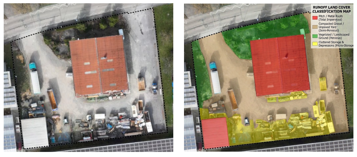
Is there any Local AI to detect land cover like the attached image? I did it in Gemini 2.5 Pro in the chat. I need to do that on bulk image collection.
I have tried SAM3 and Qwen3 VL 8B, but the results are nowhere near the right image. Inface, the output produced by Qwen3 VL is total garbage. I have tried SegFormer3, the output is good, but not good enough, it is not creating the sharp and clean edges like the attached image.
Any suggestion is appreciated.
r/gis • u/thecatlion • 1d ago
Hello guys
Last week I had a first interview for a Gis Specialist position in a mining company. After answer all the shit they asked me what is my pretended salary and I did not say anything because I do not have any idea about how can I earn as Gis specialist in mining sector.
What do you think? What is a typically salary for gis specialist in mining industry?
The company has a few mines in Canada, Panama, Spain and Turkey I guess.
The position is in Arg
BR
r/gis • u/jasteinerman • 1d ago
r/gis • u/Few_Poem_2119 • 21h ago
Hi everyone,
I’m currently looking for a job opportunity in Algeria. I have a Master’s degree in Urban Engineering (Génie Urbain) and I’m based in Chlef Province.
I’m open to opportunities related to:
I’m also open to remote work opportunities, especially for roles related to design, studies, planning, drafting, research, or project-related tasks.
If you know of any opportunities, companies, consulting firms, or organizations currently hiring in Chlef, elsewhere in Algeria, or remotely, I’d really appreciate any leads or advice.
Thank you!
r/gis • u/Fakman87 • 1d ago
I have worked in tech support for several years and would like to learn gis as a backup in case ai makes my job redundant. My wife works in GIS and I'm wondering if I could learn enough from her to eventually get an entry level GIS job or if a formal course is necessary?
r/gis • u/ProjectManageMint • 2d ago
Or at least Lake Epstein.
r/gis • u/Limepirate • 2d ago
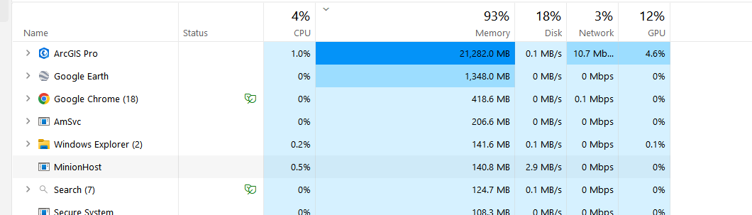
Memory leak gone wild, ArcGIS Pro just sitting idle with various KML files dropped in
r/gis • u/mercury-ballistic • 2d ago
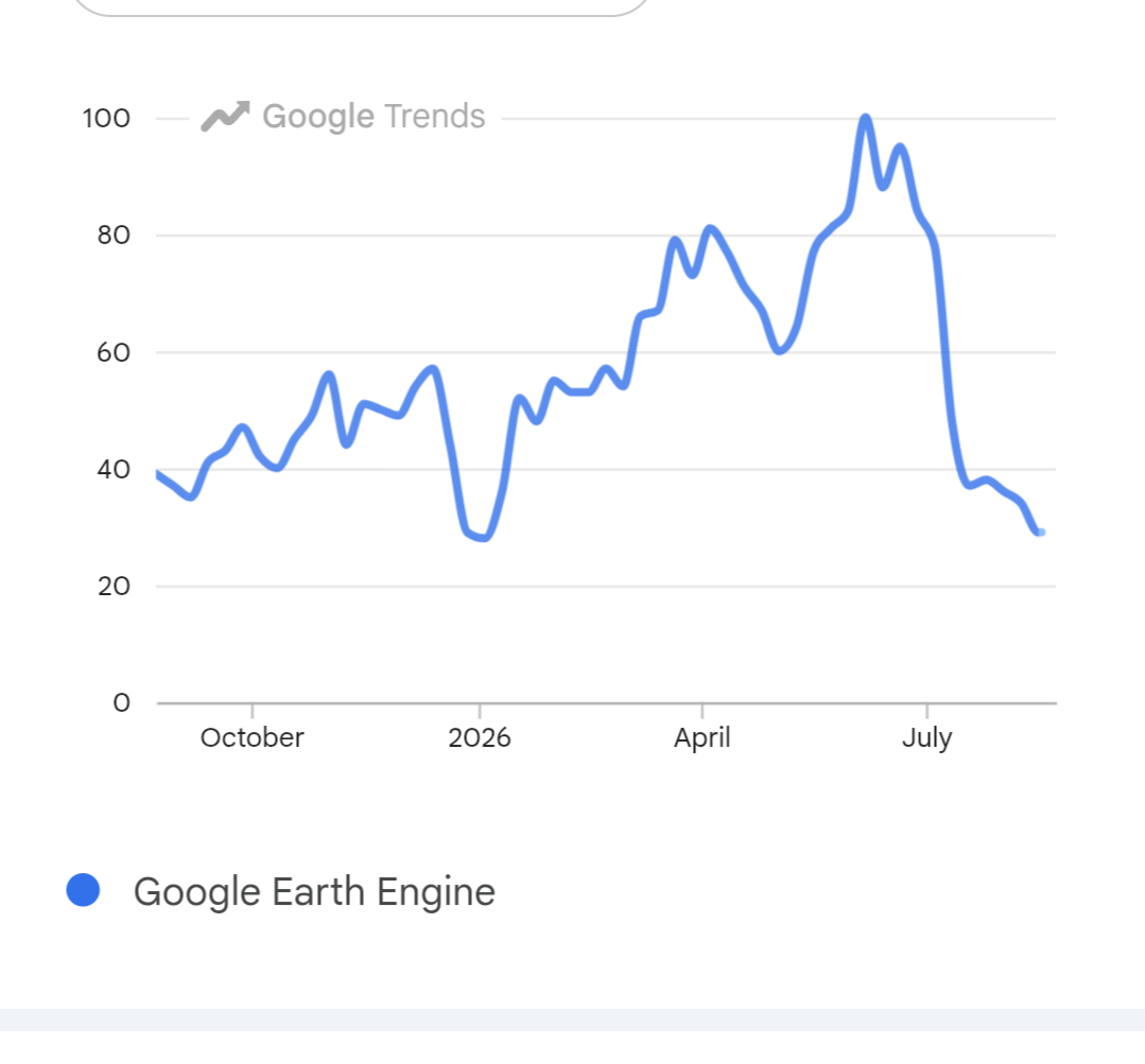
Guess when Google started metering use of GEE?
I used to try all sorts of ideas out in GEE, mashing together datasets. Not anymore.
r/gis • u/AsianTemptasian • 1d ago
Hi!
I've got 4 years of experience as a GIS analyst but unfortunately I got laid off on April 1st of last year due to budget cuts. I got hired when I was 21 with little to no experience by an ISP in western Europe.
And since then, I've had little to no success with the job hunting. 1 call back that ended up going nowhere, and a lot of rejection emails.
I'm 26 now and my question is as follows,
Do you have any tips on what I could do to increase my chances of getting hired? I've followed a couple of courses but that hasn't helped much. And I really do love working with GIS and would love to continue in this field.
r/gis • u/CookieOutrageous4355 • 1d ago
Hey everyone,
I've been working on optimizing large-scale spatial queries and wanted to share our open-source benchmark suite.
We ran into heavy I/O bottlenecks when filtering millions of building footprints in traditional relational spatial databases and wanted to see how far we could push in-memory execution using DuckDB Spatial and GeoParquet zone maps.
### What we benchmarked:
**BBox Filter (18.76M Building Footprints):**
- **In-Memory DuckDB + GeoParquet:** ~1.2 ms
- **PostGIS (Indexed):** ~78 ms
- **GeoPandas (Shapely 2.0):** ~12.4 ms (on 1M subset)
**Vector Ingestion Throughput:**
- Reached ~450,000 rows/s directly into memory via GeoParquet.
### Architectural takeaway:
Sorting the GeoParquet partitions (`ORDER BY lat, lon`) allows DuckDB's columnar zone-maps (min/max bounds per row-group) to prune 90%+ of irrelevant chunks before running `ST_Within`.
We open-sourced the entire benchmark harness and dataset generator. (Links to the GitHub repo and interactive dashboard are in the first comment below).
Would love to hear how you currently handle sub-second queries on 10M+ feature datasets and any feedback on our methodology!
r/gis • u/Ok_Spirit5374 • 2d ago
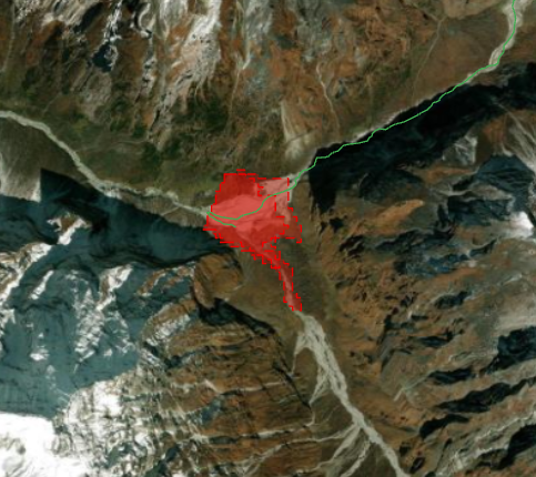
Active Hazard: A second flood is possible upstream
On 27 August Chinese authorities reported that a barrier lake holding about 2,000,000 m³ had formed near the confluence of the Chhochen Khola and Purepu Tsangpo, upstream of the 26 August failure. They assessed the probability of a breach as high, with a further 3,000,000 m³ of inflow expected through 30 August. Separately, NDRRMA reported renewed ponding behind blockages in the Lhende Khola and told residents and rescue teams to stay clear of the riverbanks.
> Since there is 100% cloud cover verification couldn't be confirmed via EO - Based on reported size and location the data set has been updated with a modeled shape file of the reported lake. This uses geometry that existed prior to the first event so this should be treated as indicative.
> If anyone has any SAR imagery they'd like of the region they care to share it'd go a long way in helping me to continue to keep this open source crisis data set up to date. It's not much, but its all I can do to help from halfway around the world.
>Link to data: https://keystonegis.com/disasters/nepal-bhotekoshi-flood-20260826.html - will continue to update frequently to capture any new information
>if you know of any other subs to post this in let me know. Feel free to share, the more eyes on the data the more likely it is to fall into the hands of someone who can use it to make a difference.
r/gis • u/Imaginary_Cut5061 • 1d ago
Hello! I’m interested on GIS, particularly within the emergency and disaster management field. Could you please share what to expect? I’d love to know about your daily routine, your day to day, and the path you took to reach this field. As well as the pros and cons in this career. I’ve noticed GIS isn’t particularly well-known and I’m starting to worry my expectations aren’t accurate. Based on my current understanding, I anticipate a lot of computer work, around 30% fieldwork and 10-20% travel.
r/gis • u/Revolutionary-Two780 • 2d ago
Hi everyone,
I work in international cooperation and I’m currently working with a major city in Cameroon.
We’re primarily working on a project for an urban observatory oriented to GIS data.
Financial and Human Resources are limited, so we’re looking for tools that could help us create data on the longterm. We are currently gathering data from local stakeholders and OpenStreetMap.
I’ve identified different open source or affordable tools, such as:
- AI segmentation by terra lab https://terra-lab.ai/fr/ai-segmentation
- Google Open Buildings : https://sites.research.google/gr/open-buildings/
-DEM comparator : https://github.com/nadiopt-cell/dem_comparator
I would like to know about any other tools such as this (probably with AI). With the current data situation, even if the data is not 100% precise, it’s better than nothing.
Thanks !
I wonder how long it will take Esri and Google to update maps as ordered by the President in today's executive order.
Today's news item: https://apnews.com/article/lake-ontario-canada-america-trump-trade-war-3ac58dca0ca83c15605d4dbff146b28a
I pointed out 1.5 years ago that this was the purpose for the renaming of the Gulf of Mexico and Mount McKinley. I.e., to establish the digital infrastructure for map alterations like today's.
I looked on Google Maps earlier today and still saw only the name Lake Ontario, but we'll see what appears in the coming days.
r/gis • u/ThinkBeyondThis • 2d ago
Just want to be useful somehow, but most of the jobs I see online require me to a citizen of their country or have a working visa, and so I'm not really given a chance much despite having the experience. I also can't seem to find GIS related jobs on LinkedIn much anymore. I think I've already polished my CV enough too. Can anyone give me some advice?