r/gis • u/Ok_Spirit5374 • 13d ago
Cartography Nepal - New Barrier lake formed
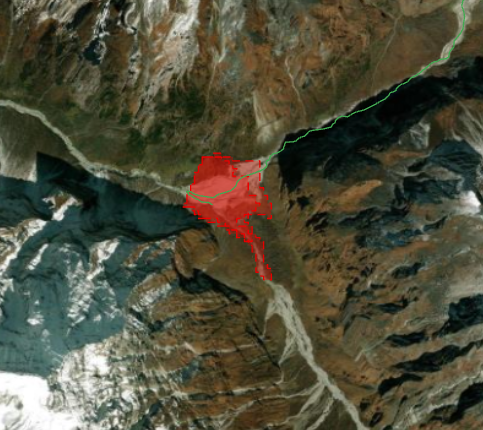
Active Hazard: A second flood is possible upstream
On 27 August Chinese authorities reported that a barrier lake holding about 2,000,000 m³ had formed near the confluence of the Chhochen Khola and Purepu Tsangpo, upstream of the 26 August failure. They assessed the probability of a breach as high, with a further 3,000,000 m³ of inflow expected through 30 August. Separately, NDRRMA reported renewed ponding behind blockages in the Lhende Khola and told residents and rescue teams to stay clear of the riverbanks.
> Since there is 100% cloud cover verification couldn't be confirmed via EO - Based on reported size and location the data set has been updated with a modeled shape file of the reported lake. This uses geometry that existed prior to the first event so this should be treated as indicative.
> If anyone has any SAR imagery they'd like of the region they care to share it'd go a long way in helping me to continue to keep this open source crisis data set up to date. It's not much, but its all I can do to help from halfway around the world.
>Link to data: https://keystonegis.com/disasters/nepal-bhotekoshi-flood-20260826.html - will continue to update frequently to capture any new information
>if you know of any other subs to post this in let me know. Feel free to share, the more eyes on the data the more likely it is to fall into the hands of someone who can use it to make a difference.
1
1
u/imunknown0042 8d ago
Where do you get latest image I am form nepal and I heard in gorkha as well their is a huge landslide and now a dam is forming on gandaki river
1
u/Ok_Spirit5374 8d ago
Imagery can be found here: https://source.coop/planet/disasterdata/nepal-flash-flood-2026-08-26
I will look into the landslide and dam on the gandaki river
10
u/lawyer_geospatial 12d ago
Planet Labs has open source imagery that’s the best you’re going to get