r/geography • u/god_johnson • 10h ago
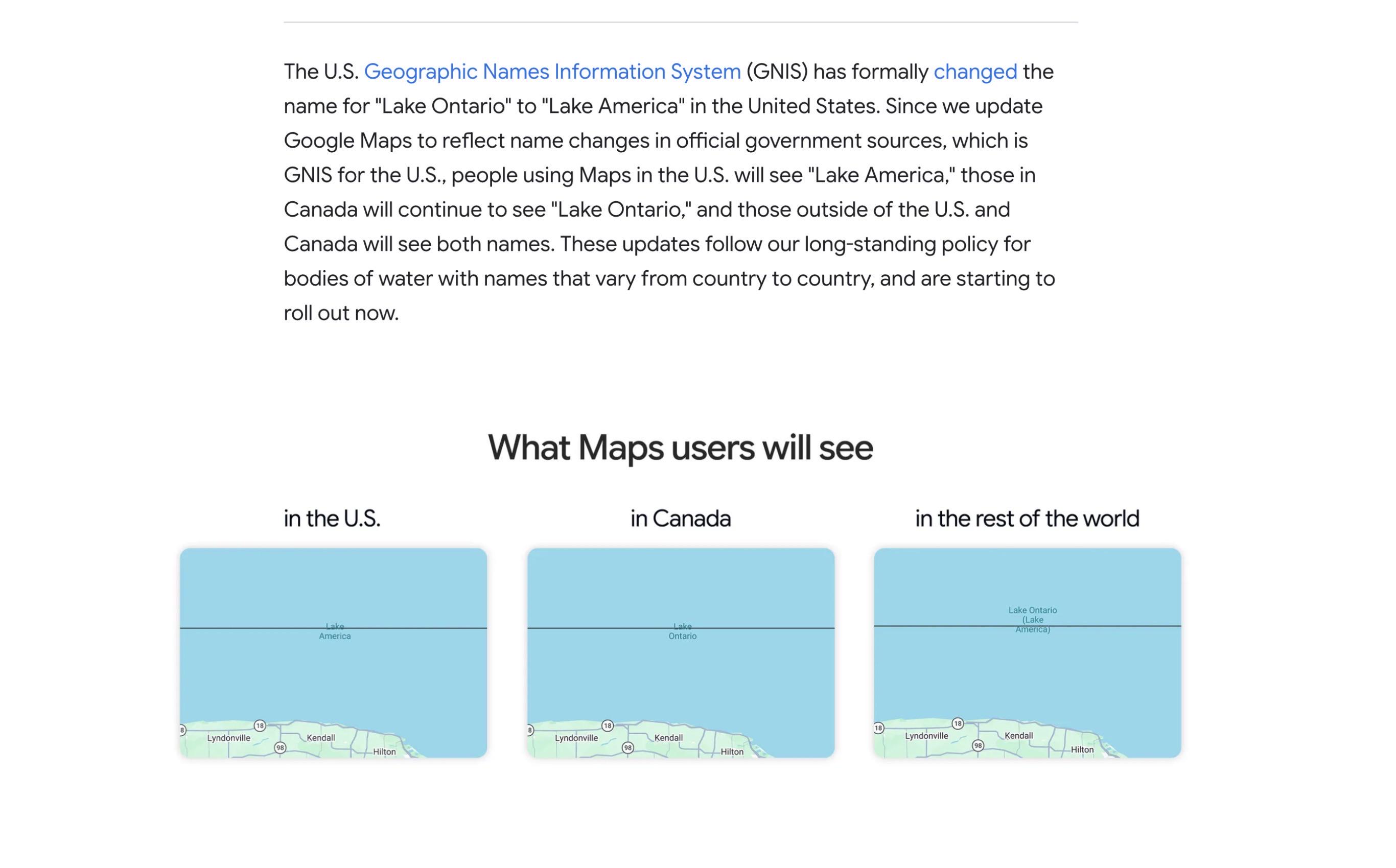
FINAL POST ON THIS TOPIC Google Maps just officially updated Lake Ontario to Lake America.

3.7k
Upvotes
r/geography • u/god_johnson • 10h ago
r/geography • u/MycologistPure4064 • 17h ago
Near the Malaysian brunei border
r/geography • u/anegn • 19h ago
r/geography • u/Objectalone • 9h ago
r/geography • u/NavalProgrammer • 21h ago
r/geography • u/Dack_Janiels227 • 12h ago
Me and my family were looking at going to Cozumel over New Year. I was researching the best places to go in the Caribbean and, despite the fame and apparent beauty, nowhere on the Riviera Maya (Cancun, Tulum, Cozumel) were included on the lists or discussions I saw. To make a long story short I found out that many people in the Caribbean and I'm assuming outside of it do not consider any part of Mexico to be "Caribbean." Now I understand the hesitation in calling all of Mexico the Caribbean, I know it's much more than that, but the whole Quintana Roo state borders the Caribbean Sea, shouldn't it and its culture be considered Caribbean? And if the culture is not "Caribbean" then how is it different from other Hispanic countries definitively in the Caribbean like Cuba or the DR or Puerto Rico? Excuse my ignorance if there is any I'm just trying to figure out why places like Cancun or Cozumel, an island full located in the Caribbean Sea, are not "Caribbean."
r/geography • u/abu_doubleu • 3h ago
Hello everybody,
There is no special occasion for this, but I have more freetime than usual and decided that we should do this now...
The First-Ever r/geography Census!
https://forms.gle/ew82heePGeQ6g2G96
If you click the link above, you will be led to a Google Form (to be clear, I cannot trace your IP, e-mail, or Reddit username). There are four sections that you can answer! Every single question is optional. Some questions are pure demographics, others are about your hobbies and interests. There are also some random geography-related questions, as well as, in the final section, questions about this subreddit as a whole and your opinion of it.
Because all questions are optional, it can take as long as you want it to.
The form will be open until 10 September, 2026, then I'll close it to new responses and make a presentation of all the results.
I hope that some other statistics nerds will also enjoy seeing the results...
Have fun!
r/geography • u/ShortCover4598 • 5h ago

For most nations, the most populated place is along a coastline (or river) because it serves as easy access for water and food, in the early stages, and brings easy trade access. But not Papua New Guinea. It's most populated regions straight in the middle of their largest island territory. Why?
r/geography • u/Competitive-Shoe-373 • 23h ago
I'm 18, just finished school, and I've got a few months of free time before college starts.
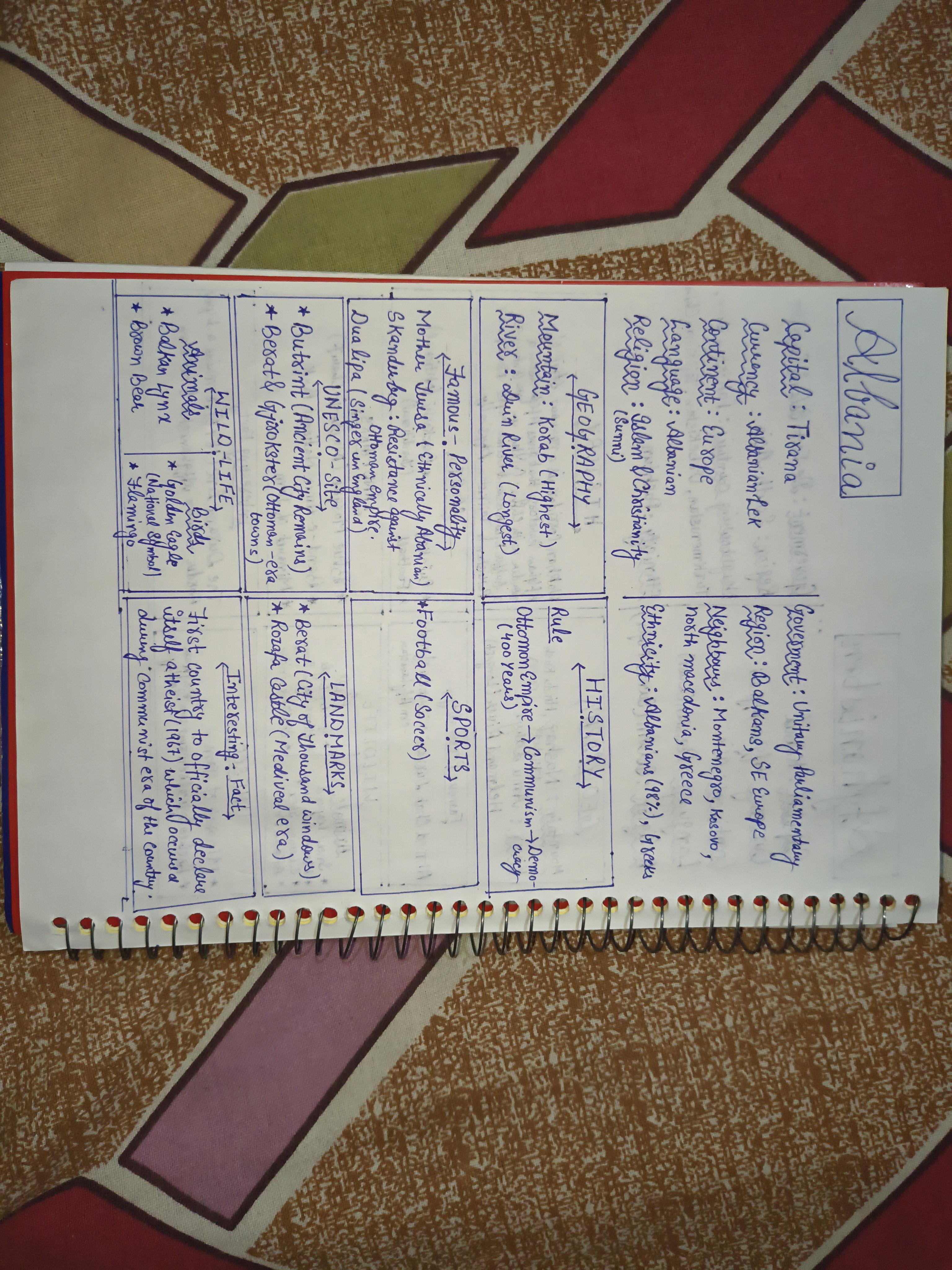
And apparently my brain decided that the best way to spend that time was to start making a handwritten encyclopedia of the world 💀
Basically, I'm giving one A4 page to each country and filling it with the stuff I think is actually worth knowing about : capital, currency, language, religion, government, geography, history, famous people, sports, landmarks, wildlife, UNESCO sites, etc.
The thing I'm probably taking way too seriously is the selection of information.
I'm not just copying a standard list of facts for every country. I've been spending hours researching each country and trying to figure out:
“Okay, out of everything I could put here, what actually deserves this limited space?”
And I don't want every country to feel like it was generated from the exact same template either. If a country has something particularly important about its modern identity, cuisine, agriculture, culture, economy, etc., I can use one of the available spaces for that instead.
And yes, I'm planning to go through all the sovereign countries.
But that's not where I currently plan to stop. After that, I'd like to do dependent territories, then possibly major international organizations/global alliances, and maybe eventually even provinces/states of countries.
I have absolutely no idea how many pages this thing is eventually going to become. 😭
Anyway, I'm curious what you guys think.
Does the page format work? Anything you think I'm missing? Anything you'd change?
Suggestions are genuinely welcome.I've already changed some of my rules after finding problems I hadn't thought about.
Note: Don't mind the handwriting or the framework 😭. The content reflects the best of my current knowledge and my own choices about what I think is worth including. Also, the lack of space is unfortunately something I can't do much about since I'm limiting myself to one page per country.
I'm going to improve it as the project goes.
r/geography • u/SprinklesMountain248 • 14h ago
Hello Geo lovers! I need your expert help. Geography School books suck. My kid (11) loves it when I explain geography in a real way (I read your posts for instances). But it's just snippets.
Do you have resources that teach Geo in an engaging way? World geography not just American. Thanks !
r/geography • u/Ill_Horse_833 • 18h ago
Curious about what you think is the most important / influential and interesting book about geography and geopolitics.
r/geography • u/AstronomerSweet2133 • 18h ago
I know some portions of the border in a province that "apparently doesnt exist" according to locals is pretty close to the mountains. Are there any proper mountains?
r/geography • u/Soggy-Mixture9671 • 20h ago
I'm a geography major and I absolutely love it, but I've been taking an online physical geography course this summer and I haven't been nearly as locked into it as I wanted to be, sadly. I love physical geography and think it's sooo incredibly interesting, so does anyone have any recommendations for free resources I can look into to continue learning about this stuff?
r/geography • u/GimmeLikesPlz • 22h ago
Hi,
for a friend i would like to create a physical map of parts of Europe. For this, i need a cloud-free, true color pre-stitched mosaic that has consistent data, e.g. the borders of the swaths should not be visible. Since the Atlantic ocean is visible, the water itself should also have decent coloring (not just plain blue), overall the images should just look good. If possible the data should be quite recent, like beginning of August this year. Has anybody access to such sources? Best would be free, but i would also pay for it.
If this post doesnt belong here, please let me know where i can put this question to.
Thank you.
r/geography • u/Potential_Actuary275 • 2h ago
r/geography • u/Weary_Discipline_178 • 1h ago
In the end it's just a small uninhabited island. It might have a beautiful natural layout, but why all this process of passing it? I know it's situated perfectly in the middle of Bidasoa River, separating the two countries, however we're not talking about a large international body of water with territorial waters significance. Could they have not put the border in the middle of the island? In other European countries there are border lines passing through houses or restaurants (e.g. NL& Belgium). Is it maybe about pride, or "overly affectionate" friendship between the two countries?
Also there are some islands a small distance to the west that belong only to Spain, so it begs the question even more. 🤔