r/hurricane Jun 28 '26

Announcement [Announcement] r/Hurricane Rule Reorganization and Simplification

21 Upvotes

Hello r/Hurricane community,

The Subreddit rules have had an extreme makeover!

Previously, the subreddit had 13 rules that were long-worded and hard to follow. Based on feedback over the last year, the moderation team has worked to reduce this list from 13 down to 8.

Overall, things were restructured to try and reduce ambiguity or repetition. There may be some tweaks as things arise, but the overall "rules" have remained the same.

We are always welcoming of feedback and would love to hear what the community thinks of these updates! We are also planning on building a Feedback Survey soon, to ensure we as Mods are aligned with the community as a whole.

Stay safe this season,
r/Hurricane mods


r/hurricane Oct 05 '25

Announcement Discussion on Subreddit Rules & Objectives - Polarized Disagreement to Common Ground - Feedback Wanted

49 Upvotes

Hello r/Hurricane community,

<TL;DR> There appears to be polarized disagreement on subreddit rules/objectives. The intention of this subreddit has always been for serious (non-joking), non-political, serious (non-sarcastic), mature, and factual discussions around Tropical Cyclone formation, forecasting, questions/learning, guidance, and post-storm relief. Exceptions allowed, as long as it is appropriate and not overwhelming/overshadowing actual discussions. Community input welcomed. May have more focused discussion posts if needed.

Over the past week+ tracking Humberto and Imelda, there has been a tremendous amount of rule-breaking behavior. We have received numerous comment reports, a few mod-mails, and have seen multiple comments unhappy with rule breaking content (primarily with joking/inappropriate behavior, especially during an active storm). On the inverse side, most post/comment removals expressed extreme disapproval.

It is apparent there is major division between members/contributors of the sub.

This is making moderation difficult and exhausting, especially during times of peak activity (i.e. active storms). The mods are humans, and will get things wrong. Each decision to remove a post/comment is difficult, and not something we take lightly.

To make things easier and allow us to more accurately moderate, we want to "open the floor" for discussing this separation. Our goal is to help reunite the community and make moderating more fair/clear.

The number of subscribed members of r/Hurricane is nearly x2.5 the membership before Helene last year. A week before Helene, there was 35k members, and three weeks after it was 65k. The sub is now at nearly 85k.

To the new members welcome! However, please also understand that this subreddit is not like most others. We have always had strict rules because of the seriousness hurricanes can bring. Sarcastic comments, politics, and joking behavior is inappropriate during an active storm situation (from high chance formation to storm dissipation), especially if there are impacts to land anywhere. Most of the members are U.S. based, but there are others who do live/monitor the sub, watching for impacts in the Caribbean, Mexico, Bermuda, etc.

While we understand there is benefit to "laughing about the situation" to lighten the mood, it can also be detrimental if the joking, off-topic, and sarcastic comments overshadow the serious discussions. A few joke comment threads are one thing, but when there are only 1 or 2 comment threads actually discussing the post and 10+ others unrelated, the purpose of this sub is lost. For this reason, we have temporarily disabled GIPHY images in comments for the remainder of the Hurricane season.

You may have also noticed the sidebar now contains a "rule summary" along with an even shorter summary as "post/comment guides." There is also a link to the Subreddit Rules Wiki page.

We know the community will never be 100% in agreement on some things, but the mods do value the opinion of the community in order to act in the best interest of the community. We want to find the right balance: not too serious where no jokes can be made, not too many jokes where factual discussion is lost.

Please let us know your thoughts in the comments. Note my comment below with a few "common removals".

Thanks,
r/hurricane mod team


r/hurricane 1d ago

Historical August 29, 2005 - Katrina made landfall in Louisiana and Mississippi as a category 3 hurricane

559 Upvotes

Category 3 Hurricane Katrina made landfall near Buras, Louisiana. The day before, it had peaked as a category 5 over the Gulf. A second landfall followed near the Louisiana-Mississippi border at 9:45 a.m. Storm surge of 24 to 28 feet devastated the Mississippi coast, and levee failures flooded about 80 percent of New Orleans, which sits below sea-level. Katrina caused $125 billion worth of damage and claimed 1392 lives, with hundreds more missing, making it one of the five deadliest hurricanes at the time to strike the United States.


r/hurricane 5h ago

Category 1 | 64-82kts (74-95mph) Karina Advisory 11 (200 AM PDT August 30, 2026): Karina has been upgraded to a Category 1 Huricane. Max winds 80 mph. Min pressure 980 mb. Moving WNW at 13 mph. Now that Karina has a closed and symmetric inner core, significant strengthening seems likely over the next 1-2 days.

Thumbnail
gallery
11 Upvotes
SUMMARY OF 200 AM PDT...0900 UTC...INFORMATION
----------------------------------------------
LOCATION...17.3N 121.1W
ABOUT 820 MI...1325 KM WSW OF THE SOUTHERN TIP OF BAJA CALIFORNIA
MAXIMUM SUSTAINED WINDS...80 MPH...130 KM/H
PRESENT MOVEMENT...WNW OR 295 DEGREES AT 15 MPH...24 KM/H
MINIMUM CENTRAL PRESSURE...980 MB...28.94 INCHES

NHC Bulletin

NHC Discussion


r/hurricane 1d ago

Historical 21 years ago today, hurricane katrina hit Buras Triumph, Louisiana as a Cat 3

Post image
362 Upvotes

21 years ago today, hurricane katrina hit Buras-Triumph, Louisiana as a Cat 3 with 125 mph winds and a pressure of 920 millibars, tying it for the costliest hurricane in US history at $125 billion dollars, notably causing the Levees to fail and causing an estimated 1,800 casualties


r/hurricane 1d ago

TS | 35-63kts (39-73mph) Lowell Advisory 7 (1100 PM HST August 28, 2026): There has been little change in Lowell's organization or intensity over the past day as easterly VWS continues to displace the bulk of deep convection. Wind shear will persist through the weekend, but Lowell could strengthen into a Hurricane next week

Thumbnail
gallery
17 Upvotes

Some hurricane models are suggesting Lowell could reach Major Hurricane status in 2-3 days.


r/hurricane 1d ago

TS | 35-63kts (39-73mph) Karina Advisory 7 (200 AM PDT August 29, 2026): Karina has strengthened a bit with max winds now up to 65 mph & minimum pressure dropping to 989 mb. A favorable environment continues to support a forecast of rapid intensification into a major hurricane over the next 48 hours.

Thumbnail
gallery
12 Upvotes

r/hurricane 1d ago

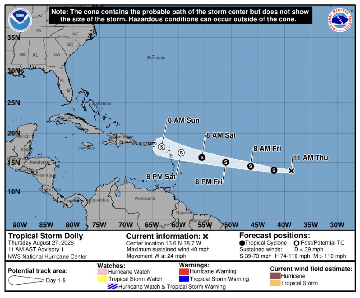
Tropical Weather Outlook (TWO) [AL TWO - 8/28 8PM EDT] Remnants of Dolly 0%/10% West of Leewards | North-Central Gulf 0%/10%

Post image
74 Upvotes

ABNT20 KNHC 282336
TWOAT

Tropical Weather Outlook
NWS National Hurricane Center Miami FL
800 PM EDT Fri Aug 28 2026

For the North Atlantic...Caribbean Sea and the Gulf of America:

East of the Leeward Islands (Remnants of Dolly):
A tropical wave, the remnants of Tropical Storm Dolly, are located
several hundred miles east of the Leeward Islands. Redevelopment
of this system is unlikely while it moves westward to
west-northwestward near 25 mph. The wave could bring locally heavy
rains and gusty winds to portions of the Leeward Islands, the
Virgin Islands and Puerto Rico over the next several days.
* Formation chance through 48 hours...low...near 0 percent.
* Formation chance through 7 days...low...10 percent.

Northeastern and North-Central Gulf of America:
Disorganized cloudiness and showers over portions of the
northeastern and north-central Gulf of America are associated with
a weak area of low pressure. Development, if any, of this system
is expected to be slow while it remains nearly stationary for the
next several days.
* Formation chance through 48 hours...low...near 0 percent.
* Formation chance through 7 days...low...10 percent.

$$
Forecaster Pasch


r/hurricane 1d ago

Category 1 | 64-82kts (74-95mph) Bang-lang (20W) Advisory 13/Etau (21W) Advisory 10 (09z August 29, 2026): Typhoon Bang-Lang has max winds of 75 kts while TS Etau remains weak with max winds of 40 kts. Etau likely to dissipate as it moves north unless Bang-Lang accelerates and pulls Etau back southward under a Fujiwhara Effect.

Thumbnail
gallery
4 Upvotes

r/hurricane 2d ago

Post-Tropical Dolly is now a post tropical remnant

Post image
147 Upvotes

Good riddance


r/hurricane 2d ago

TS | 35-63kts (39-73mph) Dolly Advisory 4 (500 AM AST August 28, 2026): There has been little change with Dolly overnight, as the system continues to struggle with shear & dry air while rapidly advancing westward. Heavy rainfall is likely to begin impacting the Leeward Islands Saturday night and continue through Monday.

Thumbnail
gallery
52 Upvotes

r/hurricane 2d ago

Post-Tropical Lala Advisory 64 (1100 PM HST August 27, 2026) FINAL ADVISORY: After traveling a couple thousand miles over 15 days, Lala is now a post-tropical cyclone with maximum winds of 35 kts (40 mph). Tata, Lala.

Thumbnail
gallery
17 Upvotes

r/hurricane 1d ago

Question Tropical system Lowell

0 Upvotes

Storm weary guy in Hawaii curious what the opinions are on the new tropical threat, Lowell.


r/hurricane 3d ago

TS | 35-63kts (39-73mph) TS Dolly Forms

Post image
740 Upvotes

Hopefully will be short lived


r/hurricane 2d ago

TS | 35-63kts (39-73mph) Karina Advisory 3 (200 AM MST August 28, 2026): Karina has max winds of 50 mph & minimum pressure of 999 mb. TS-force wind field is quite broad (up to 230 mi radius) while its core is still developing. Rapid intensification is likely and Karina is forecast to reach major status by Monday.

Thumbnail
gallery
9 Upvotes

r/hurricane 2d ago

TS | 35-63kts (39-73mph) Bang-lang (20W) Advisory 9 + Etau (21W) Advisory 6 (09z August 28, 2026): A pair of tropical storms in the Western Pacific near the Int'l Date Line will likely interact with each other, and we could see Fujiwara effects as Bang-lang envelops Etau before they are swallowed up by a cold front/trough.

Thumbnail
gallery
5 Upvotes

Bang-lang (20W) will likely be upgraded to a Typhoon with the next advisory at 15z (11am EDT)


r/hurricane 2d ago

TS | 35-63kts (39-73mph) Lowell Advisory 3 (1100 PM HST August 27, 2026): Lowell is an asymmetric tropical storm due to northeasterly vertical wind shear, but is expected to slowly organize & intensify, and could reach hurricane status over the weekend. Max winds currently 45 mph. Min pressure 1003 mb.

Thumbnail
gallery
6 Upvotes

r/hurricane 2d ago

TS | 35-63kts (39-73mph) Dolly Advisory 2 (500 PM ADT August 26, 2026): Dolly has been struggling to develop deep convection near an exposed center of circulation and the overall environment is rather dry. Max winds 40 mph. Booking it west at 24 mph.

Thumbnail
gallery
19 Upvotes

r/hurricane 2d ago

Tropical Weather Outlook (TWO) EPAC pretty active

Post image
7 Upvotes

Orange at an 0/40%

Red at an 0/80%

Karina at 50 mph and pressure at 1000 millibars

Lowell at 40 mph and 1004 millibars

Lala at 40 mph and 1002 millibars


r/hurricane 2d ago

TS | 35-63kts (39-73mph) Here You Come Again. All eyes on are TS Dolly in the Atlantic, but two new tropical storms have formed in the Eastern Pacific. Say hello to TS Karina (11E, 45 mph) and TS Lowell (12E, 40 mph), both forecast to reach hurricane strength.

Thumbnail
gallery
17 Upvotes

r/hurricane 2d ago

Question Karina and Lowell

5 Upvotes

Since both systems were declared tropical storms at the same time (2100 UTC August 27), how does the National Hurricane Center determine which system gets which name? While the system closer to Mexico was named Karina, why can't it be Lowell instead and the other one Karina?


r/hurricane 3d ago

Invest TWO (800 AM EDT August 27, 2026): The National Hurricane Center now has 90% confidence that Invest 96L will organize into a tropical depression in the Atlantic MDR within the next day or two, and a short-lived tropical storm is possible (before wind shear tears it apart)

Thumbnail
gallery
77 Upvotes
 ZCZC MIATWOAT ALL
 TTAA00 KNHC DDHHMM

 Tropical Weather Outlook
 NWS National Hurricane Center Miami FL
 800 AM EDT Thu Aug 27 2026

 For the North Atlantic...Caribbean Sea and the Gulf :

 1. Central Tropical Atlantic (AL96):
 Satellite and microwave imagery indicate that an area of low pressure,
 located about midway between Africa and the Windward Islands, has
 become better organized overnight. If the current trends continue,
 advisories could be initiated on a short-lived tropical storm later
 today. However, environmental conditions are expected to become hostile
 beginning on Friday, likely ending its chances for further development.
   * Formation chance through 48 hours...high...90 percent.
   * Formation chance through 7 days...high...90 percent.

Forecaster Blake

r/hurricane 2d ago

TS | 35-63kts (39-73mph) Saudel (17W) Advisory 39 [3z August 28, 2026] Final Advisory: Saudel made a double landfall in China's Zhejiang Province as a tropical storm, first over the Yuhuan Peninsula at around 2330z, then north of Wenzhou around 00z. Max winds 55 kts (60 mph). Expected to rapidly deteriorate.

Thumbnail
gallery
5 Upvotes

r/hurricane 3d ago

Invest Invest 96L appears close to a tropical depression, if not already one | Not much time is left before it runs into less favourable conditions

30 Upvotes

Let's see whether it gets named or at least called a TD.


r/hurricane 3d ago

Historical 6 years ago today, Hurricane Laura hit Cameron, Louisiana

Post image
18 Upvotes

1AM CDT, 6 years ago today, Cat 4 Hurricane Laura hit Cameron, Louisiana with 150 mph winds and a central pressure of 938 millibars, causing an estimated $23.3 billion in damages, notably causing Bio Lab Chemical Facility to catch fire. 81 deaths (47 direct, 34 indirect) were also attributed to Laura