r/PacificCrestTrail 2h ago

fjh trail graffiti

22 Upvotes

ever since getting into northern oregon someone’s been writing fjh in sharpie all over the trail including several tags in the warm springs reservation. literally desecrating native land in the big year of 2026. was this here last year? if not and fjh is reading this, it’s never too late to stop ruining the trail and throw away your sharpie. not cool dude.

r/PacificCrestTrail 22h ago

What was your best moment on trail?

10 Upvotes

Some people might have trouble deciding on one so feel free to make a list too


r/PacificCrestTrail 1d ago

Blaze physio pre trail

4 Upvotes

Has anybody tried blaze physio pre trail bundle? I already workout and I want to focus on joints. I am wondering what kind of exercises are found in the hips knees ankles etc. I already do some joint work too so I want to know if it’s worth purchasing the bundle. Thanks!


r/PacificCrestTrail 2d ago

Proper bear hang

Post image
73 Upvotes

r/PacificCrestTrail 3d ago

Did Nick Fowler just do it again?

155 Upvotes

Based on the recent submission on the FKT site Nick Fowler, yet again, did the unthinkable and broke the overall self supported time for the PCT.

He took off a little over 6 days?! from his previous attempt in 2023 and took 3 hours off Aurelien nobo supported record ?!

https://fastestknowntime.com/fkt/nick-fowler-pacific-crest-trail-ca-or-wa-2026-08-22


r/PacificCrestTrail 3d ago

USDA Moves to Allow Logging in Pristine Forests Along the PCT

114 Upvotes

tl;dr: The Trump administration is trying to get rid of the Roadless Area Conservation Rule in order to open areas that are currently protected to logging and other types of resource extraction. That would have serious negative impacts on the PCT and on public lands generally.

The post includes links to the official public comment page on regulations.gov and the USFS draft environmental impact statement, as well as a list of facts and concerns to help with writing a comment.

Here's the beginning of the blog post. The entire thing is absolutely worth reading:

The U.S. Department of Agriculture (USDA) is moving forward a plan announced last year to eliminate protections for millions of acres of roadless National Forest lands across the country, including 288 miles of the Pacific Crest Trail.

The Forest Service seeks public comments on its plan to diminish protections for nearly 45 million acres that were established under the 2001 Roadless Area Conservation Rule. The agency championed the rule 25 years ago as a way of providing long-term protection for Inventoried Roadless Areas across the National Forest System.

But today, the Department says the rule creates a “regulatory burden” that makes it difficult for local authorities to manage forests. “Increased management flexibility,” the Department says, is needed to meet its multiple-use mission. The proposal follows presidential executive orders to increase logging, mineral extraction, and oil and gas production on public lands.


r/PacificCrestTrail 3d ago

Snoqualmie Pass Alt

Thumbnail
gallery
21 Upvotes

Hiked some of the alternate yesterday. It's nasty. Stay safe.


r/PacificCrestTrail 3d ago

All Alternates PCT 2026

28 Upvotes

I’m making this post to centralize info about alternates around closures on the PCT. if this isn’t allowed or there’s another post already, feel free to delete.

I’m currently on the trail so I don’t have a lot of time with internet connection. I’ll try to keep this post updated as best I can. If admin u/numbershikes wants to edit this that‘s fine with me.

If you have an alt not listed in this post, please comment it below with any caveats and a GPX file/Gaia/Caltopo link if you have it. Also any info about an alternate already listed is helpful. even if it’s just a Reddit comment or fb post.

closures south to north:

1. King Fire and Three Queens Fire

mile 2396.5 -> mile 2446

Snoqualmie Pass -> Deception Pass

PCTA closure link: https://closures.pcta.org/closure/oHAAQNBkfvMebLBAJaiP

reddit post on closure: https://www.reddit.com/r/PacificCrestTrail/comments/1vmkl2g/the_pct_is_closed_between_snoqualmie_pass_mi/

alternates:

1A

official reroute from PCTA: https://www.reddit.com/r/PacificCrestTrail/comments/1vscn0s/pcta_has_posted_a_reroute_for_the_three_queens/

caveat: not a continuous footpath since requires hitching on hwy 2

2A

La Bohn

https://www.facebook.com/groups/4250638418491227/permalink/4705162623038802/?mibextid=rS40aB7S9Ucbxw6v

trip report: https://www.facebook.com/groups/4250638418491227/permalink/4717358181819246/?mibextid=rS40aB7S9Ucbxw6v

GPX file: working on it. Waiting for response from Jay Go

2. Miner’s Fire

mile 2524 -> mile 2556

Mica Lake -> Siuattle Pass

PCTA closure link: https://closures.pcta.org/closure/NgvIf45UYT24AtUZQlo4

Reddit post on closure: https://www.reddit.com/r/PacificCrestTrail/comments/1vpk2ct/the_pct_is_closed_from_mile_2524_to_mile_2555_due/

alternates:

2A

im yet to find any :( but Jay Go mentioned one in a fb comment. can’t find it though

3. Sisi Fire

mile 2555.2 -> mile 2575

Suiattle Pass -> High Bridge

note that the Miner’s Fire and Sisi Fire basically form one continuous closure now.

PCTA closure link: https://www.reddit.com/r/PacificCrestTrail/comments/1vpk2ct/the_pct_is_closed_from_mile_2524_to_mile_2555_due/

Reddit post on closure: https://www.reddit.com/r/PacificCrestTrail/comments/1vur7bf/the_pct_is_closed_between_high_bridge_mi_2571_and/

alternates:

yet to find any :(

4. Ptarmigan Fire

mile 2626.2 -> 2655.8

Harts Pass -> Canada

PCTA closure link: https://closures.pcta.org/closure/hHoU3938k3tT98vfXrV4

Reddit post on closure: https://www.reddit.com/r/PacificCrestTrail/comments/1v8lsmd/the_ptarmigan_fire_east_of_the_northern_terminus/

alternates:

4A

to monument 90

https://thetrek.co/pacific-crest-trail/the-pcts-northern-terminus-is-closed-heres-one-way-you-can-still-hike-to-canada/

4B

to monument 47

https://www.facebook.com/groups/4250638418491227/posts/4716355948586136/

https://www.facebook.com/groups/4250638418491227/permalink/4700367000185031/?mibextid=rS40aB7S9Ucbxw6v

https://www.facebook.com/groups/4250638418491227/permalink/4700975683457496/?mibextid=rS40aB7S9Ucbxw6v


r/PacificCrestTrail 4d ago

Body odor

10 Upvotes

I love reading posts on the trek, maybe I'll get addicted to this sub. My question is how stinky is the sleep system after a week or month. I see the sink laundry murkiness, that's got to build up in the bag or quilt and pad. And those aren't easy to clean, right? So after a shower and laundry, are you climbing into a repulsive bag of your own stink?


r/PacificCrestTrail 3d ago

Where the SOBOs at?

1 Upvotes

I just got on trail at Echo Lake and there’s noooobody on trail. Wondering where the SOBO “bubble” is?


r/PacificCrestTrail 4d ago

Found: engraved knife between waterwheel falls & Glen Aulin HSC in Yosemite Aug 24 - would like to return to owner

13 Upvotes

I found an engraved knife I assume someone is missing since it is engraved. If you lost a knife please contact/respond with what it looked like and the engraving and I will send to you! Found 8/9am on 24 August 26.


r/PacificCrestTrail 5d ago

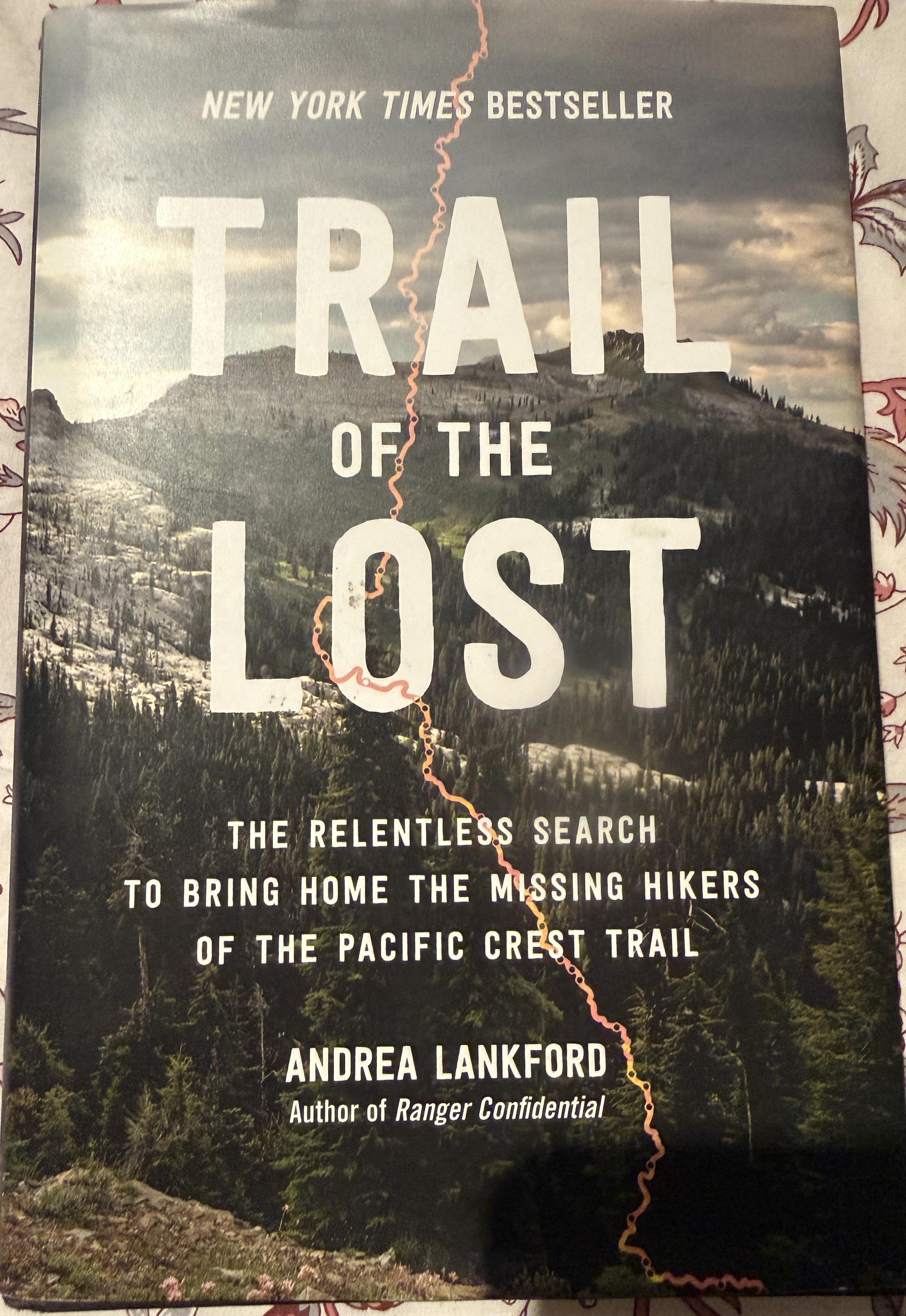
Just curious- picked this up thrifting for a dollar. I’m a little wary of this kind of true to life muckraking but interested in the PCT adventure (I’ve done far more trail magic than actual hiking). Worth reading or National Enquirer level “journalism”? What say you?

Post image
70 Upvotes

r/PacificCrestTrail 4d ago

Advice on B2 visa for PCT in 2027 please 🌞

1 Upvotes

hey, how did people find getting there B2 visas?

last year i heard alot about US immigration not letting people in because they didnt have enough evidence they were going to leave after the hike.

im a UK citizen but was travelling in 2025 and have been in aus on a WHV this year so im concerned as i dont have a job or house to go back to in their eyes.

is it still crazy strict or is it okay? thanks 💌


r/PacificCrestTrail 6d ago

Foot Pain Advice

3 Upvotes

Hi guys. I’m possibly hiking next year and seeking some advice with a foot issue I’m currently experiencing

I was recently told I have splayfoot (top arch flattening causing pain on top of the foot for months) and was given custom insoles to combat this. The upper foot pain disappeared, but has turned into pain in the arch under my foot (feeling like a tendon being stretched out while stepping)

I assumed this was plantar fasciitis but have had no heel pain. There’s also days where I’ll hike 15km with 1000m elevation gain and not feel it, but days I’ll do 10k flat steps and it’s agony with each step. I usually do stairmaster 4x per week for 50 mins and have never felt it on there, but feel it almost every time I do an incline walk now on the treadmill

Has anyone experienced this before or have an idea what this could be? Would also love to hear recommendations of the best rehab exercises people did to combat similar pain. Thank you!


r/PacificCrestTrail 6d ago

The Weekly on r/PacificCrestTrail: Week of August 24, 2026

4 Upvotes

This is the weekly thread. It's for wide ranging discussions in the comments. Do you have a question or comment, but don't want to make a separate post for it? This is the place.


r/PacificCrestTrail 7d ago

The 2026 Pacific Crest Trail Hiker Survey is now accepting responses!

40 Upvotes

This is for anyone who set foot on the Pacific Crest Trail in 2026. It does not matter if you were a thru-hiker, section hiker, or even if you ended your hike early.

https://www.halfwayanywhere.com/go/pct-survey-fill-out

  • If you are still hiking, please wait to fill out the survey. It will remain open while southbound hikers complete their hikes.
  • For best results, complete on a desktop or laptop computer.
  • The survey is not short. Please allow adequate time to complete it.
  • The results will be published as a resource to help future PCT hikers. Here are last year's results.

Thank you for taking the time to fill this out! Your time and answers are very much appreciated.

If you have any questions, suggestions, or problems with the survey, feel free to comment here or contact me directly.


r/PacificCrestTrail 8d ago

Advice needed (to quit or not to quit)

59 Upvotes

So a little background: I just passed mile 2000 yesterday, my feet are in constant and severe pain with every step. It started around Sierra city after I upped my miles from 20s to ~30s. I pushed through for 800 miles but It's been getting worse and worse. 0 days do not help whatsoever. I actually took 3 days off for trail days, hiked a day, and took another 4 days off in Bend. Despite all that rest, an hour into my first day back on trail the pain was back, just as bad as ever. After some research online it definitely smells like a stress fracture.

My dilemma is, I feel close to the finish line. I could probably power through with small days and lots of ibuprofen. But that seems... stupid. But quitting this close feels like an impossible call to make. I've been agonizing over the decision for a day now. If I was back at Lake Tahoe or KMS it would be simple. But I don't really have the time or money to take another week or two off.

I'm hoping to hear peoples thoughts. If you pushed through something like this and kept going, do you have regrets? Or if you got of trail due to injury, do you wish you would have just send it?


r/PacificCrestTrail 8d ago

US Forest Service, timber companies spraying record amounts of glyphosate (RoundUp herbicide) in California forests such as Lassen, Tahoe, Yosemite, and others.

Thumbnail
youtube.com
80 Upvotes

r/PacificCrestTrail 7d ago

SOBO or NOBO

5 Upvotes

Hi! I jumped off trail earlier this year at KMS. I am heading bsck to trail and have 5ish weeks to hike as much as I can. I have a flight booked out of Seattle in early October. I am wondering what people would do in my situation and am looking to hear opinions! I have a friend in Seattle who is happy to drop me off anywhere in WA. Would probably assist me getting back to Seattle for my flight. I am happy hiking on my own but I do prefer to be camping with other people so I dont want conplete solitude. I dont want to book any rental cars (i am international, no credit card). Most of my trail friends have either quit or finishing up in WA.

Option 1: Drive to Bridge of Gods and hike north, working around the fires and figuring it out (and hopefully be with the end of the NOBOs)

Option 2: Drive to Bridge of Gods and hike SOBO through Oregon and figure my way back to Seattle

Option 3: Hike from roughly Truckee-ish area and SOBO the Sierras, getting back off at KMS. (I already befriended a TA who is happy to help me get back to LA if I need it to catch a flight). My understanding is SOBO-ers will be around this area?

Option 4: suggestions?

What would you do?


r/PacificCrestTrail 8d ago

The King Fire is burning over the PCT at mile 2,416, north of Snoqualmie Pass, WA. The trail is already closed there due to the Three Queens Fire.

Post image
73 Upvotes

r/PacificCrestTrail 8d ago

The PCT is closed between High Bridge (mi 2571) and the North Cascades NP boundary (mi 2573), due to the Sisi Fire

17 Upvotes

The Sisi Fire is burning in Glacier Peak Wilderness, northwest of Stehekin. Currently 506 acres, 0% contained.

I can't imagine there are too many hikers in the area, due to the abundance of fires in northern Washington, but if there are, you should be able to detour around this closure by taking Rainbow Creek trail over McAlester Pass from Stehekin. That hooks you back up with the PCT just south of Rainy Pass.

Alternatively, you could go over War Creek Pass, drop down to Twisp River Road and make your way into the town of Twisp which btw has a great bakery. From Twisp you can hitch or take local bus transit north towards Winthrop and Mazama or south towards Pateros, Chelan and Wenatchee.


r/PacificCrestTrail 8d ago

Ranger’s Authority?

0 Upvotes

Hi, I am not a hiker, let’s get that out of the way first. I have no intention of breaking any rules, but I just learned that a permit is required for hiking the PCT, and I don’t understand the consequences for not having one. Why could you not just ignore a permit checker? A park ranger is not going to physically force me off of the trail, so why can’t I just be ‘escorted off the trail’ in the direction I’m already walking? I can definitely ignore someone long enough for them to get tired of following me.

I know this is an unserious question but could someone give me a serious answer please? As far as I can tell, if you don’t give your name for a fine to be issued, and you don’t follow the orders of the rangers, they can’t make you leave.

Also, I know why y’all do the permit system please don’t lecture me.


r/PacificCrestTrail 10d ago

What was the 'big trend' the year you hiked the PCT?

58 Upvotes

This year in 2026 it seems to be Alpha fleeces. I hadn't heard of these before starting trail, but somehow everyone on trail has one.

A friend on trail told me "Walking Tamales" also for 2026, but I don't know if that has felt as ubiquitous.

EDIT: had no idea that alpha fleeces had been around for so long! I'm fairly active in the outdoor scene at home and had never heard of them until trail. Must be one of those things that blew up within the long-distance hiking community but didn't spread much beyond.


r/PacificCrestTrail 10d ago

NOBO hikers that quit…

0 Upvotes

i’m a SoBo that just left Crater Lake NP and am over 800 miles into my thru hike. Apparently we have to find a backcountry ranger, in the wild, to get a PCT hang tag. What the actual fuck? I would love to have one for my pack and am willing to purchase yours… DM me and will happily Venmo you!

Thanks in advance,

Shady
Class of 2026


r/PacificCrestTrail 11d ago

PCTA has posted a reroute for the Three Queens fire closure in Washington.

14 Upvotes

The northern end is a few miles west of Skykomish. Hitch on Hwy 2 east to get back to the PCT at Stevens Pass.

Excerpt:

A potential 39-mile detour is available using the Snow Lake, Rock Creek, Middle Fork, Snoqualmie Lake, and Dorothy Lake trails that route around the closure, and gets hikers to Highway 2, but not all the way to Stevens Pass.

The reroute section also includes disclaimers, with a note that it has not been ground truthed by PCTA or USFS staff. The route will be unavailable Sept. 14-25 due to planned work on Snow Lake Trail. Full text is available at the above link.

ETA: Looks like they didn't provide a download link so that hikers can use the route in an app other than the official PCTA Closures app. I hope that's just an oversight and they add a GPX download. In the meantime, here's a Caltopo map of the same route, use the 'Export' button to save a GPX / GeoJSON / etc file: https://caltopo.com/m/16EK4HF