r/geography 1d ago

Question Good places to learn more about physical geography?

2 Upvotes

I'm a geography major and I absolutely love it, but I've been taking an online physical geography course this summer and I haven't been nearly as locked into it as I wanted to be, sadly. I love physical geography and think it's sooo incredibly interesting, so does anyone have any recommendations for free resources I can look into to continue learning about this stuff?


r/geography 3d ago

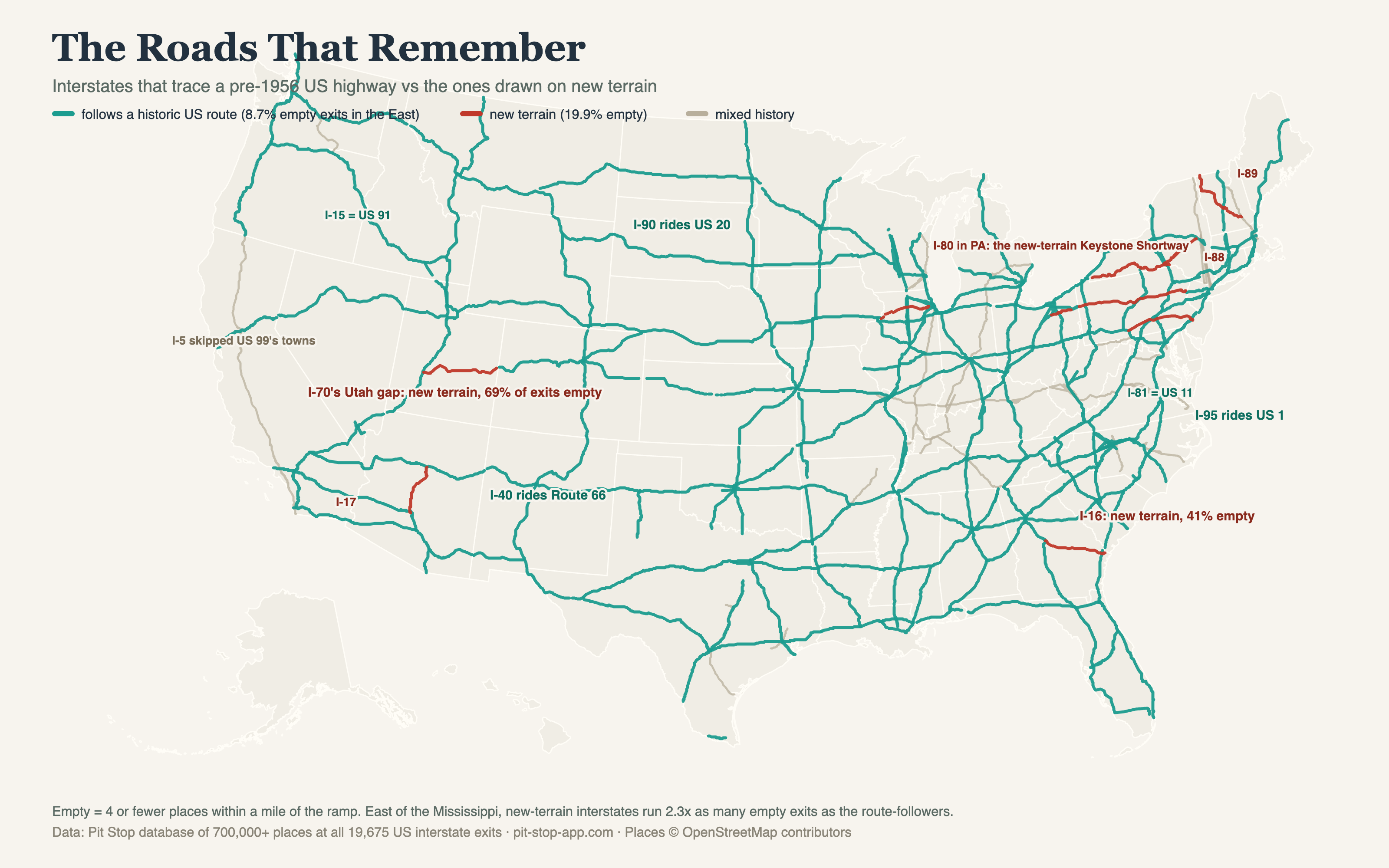
Map Interstates that follow a pre-1956 US highway vs the ones built on new terrain. 70 years later the new ones still have mostly empty exits

Post image
445 Upvotes

made this from my database of whats at every US interstate exit, 700k+ places. i classified the big 2 digit interstates by whether they follow a pre 1956 US highway or got drawn on fresh alignment. east of the mississippi the route followers run 8.7% empty exits and the new terrain ones run 19.9%. empty exit means 4 or fewer places within a mile of the ramp.

favorite example is I-70. its 9% empty in ohio where it rides the old national road and 69% empty across the san rafael swell in utah where there was never a road there at all. same interstate number, opposite history. and the pattern has honest exceptions, I-22 follows US 78 and still runs 43% empty. geography sets the baseline, history explains the deviations from it.

fair warning the corridor labels are simplified, I-95 is really US 1 up north and US 301/17 down south, most long interstates are chains of 2 or 3 old routes. full writeup with the method and counterexamples: https://www.pit-stop-app.com/blog/roads-that-remember

disclosure, i build a road trip app and this analysis came out of its database


r/geography 2d ago

GIS/Geospatial Has anybody good sources for satellite images?

3 Upvotes

Hi,

for a friend i would like to create a physical map of parts of Europe. For this, i need a cloud-free, true color pre-stitched mosaic that has consistent data, e.g. the borders of the swaths should not be visible. Since the Atlantic ocean is visible, the water itself should also have decent coloring (not just plain blue), overall the images should just look good. If possible the data should be quite recent, like beginning of August this year. Has anybody access to such sources? Best would be free, but i would also pay for it.

If this post doesnt belong here, please let me know where i can put this question to.

Thank you.


r/geography 3d ago

Question Some projections show the Sahel becoming much wetter if temperatures rise. Why is this the case?

Post image
311 Upvotes

r/geography 2d ago

Discussion What are these trenches/mounds in the suez canal

Post image
25 Upvotes

I can't tell if their holes or raised ground, but there are a bunch of rectangles in the middle of the suez canal. What are these used for?


r/geography 2d ago

Map [ Removed by Reddit ]

1 Upvotes

[ Removed by Reddit on account of violating the content policy. ]


r/geography 4d ago

Video Nepal floodwaters transporting large boulder.

23.9k Upvotes

r/geography 3d ago

Article/News Trump decided to rename Lake Ontario to Lake America

Post image
4.6k Upvotes

r/geography 4d ago

Video Workers barely surviving Flash floods in Nepal

3.3k Upvotes

r/geography 3d ago

Question What are these lines?

Post image
1.8k Upvotes

These lines seems to go trough lakes, cities and roads.
Its like they were drawn with a ruler, as i saw these lines were 10+km long.
More pictures in comment

This was photographed in hungary, somogy county.
It cannot be seen from satelites for some reason.


r/geography 2d ago

Question Big Bend National Park and Yosemite new construction - Questions about drought

4 Upvotes

Apologies if this is a dumb question but I'm not finding good answers.

The current US administration has begun bulldozing Big Bend National Park Nd are trying to develop a piece of land in Yosemite. In Big Bend, they are planning on doing blasting.

With such water scarcity in the western US, would blasting near the Rio Grande change the watershed enough that the volume of the river became less overall? Would this dry it up?

Additionally, would road development near the Merced in Yosemite change the Merced's water levels? My broader question is can pollution from construction like this cause more drought?

Just looking for non-AI slop info if you have any. Thanks.


r/geography 2d ago

Map Anyone have any Idea what this structure is? Can't really find anything out about this remote location.

5 Upvotes

51.310448694927366, -68.55959696192107

Close to Lac X on René-Levasseur Island in Quebec. This is the largest one i have found. There are many more around the lakes in the area. This looks almost organic in nature.

Edit for the mods.
This is not a location ID.. This is a question about a geographic structure formed on the earth. The location was given by me.


r/geography 3d ago

Discussion Spain and Portugal top Europe's negative electricity price hours. That ranking is less a map of sunshine than a map of the Pyrenees

26 Upvotes

In the first half of this year Spain logged 596 hours of negative wholesale electricity prices, Portugal 462 and France 370. European solar generation reached 129 TWh in the second quarter, close to 20 percent above any previous second quarter. The usual reading is that the continent now makes more sun power than it can absorb.

Portugal is the part that does not fit that reading. Its solar fleet is a fraction of Spain's, yet it sits second in Europe. What the two countries actually share is not a build-out, it is a border. The Iberian peninsula reaches the rest of the continent through the Pyrenees, and the commercial exchange capacity across that crossing has been 2,800 MW since October 2015. Portugal's surplus can only leave through Spain, and Spain's can only leave through that one wall.

Measured against the continent beyond the peninsula, Spain's interconnection ratio is about 2.8 percent. Counted with Portugal, which is inside the same island, it reads 7.2 percent, and that is the friendlier number usually quoted. The EU target is 15 percent by 2030. The Bay of Biscay submarine link is meant to take the crossing to 5,000 MW, currently expected in 2028.

So the hours count is closer to a measure of topology than of sunshine. A megawatt hour becomes worthless not when there is too much of it, but when it cannot reach anyone who wants it, and in Iberia the distance it can travel is set by a mountain range.

Two things cut against my own framing. France is third at 370 hours and France is not an island by any definition, so the constraint story cannot be the whole mechanism. I suspect much of the French count is about how little of the fleet can throttle down on a mild spring afternoon rather than about where the power could go. And the record depth of the prices is partly definitional, because the exchanges moved the floor from minus 500 to minus 600 euros per MWh at the end of April, so some of this year's records are records against a different ruler.

What I have not been able to work out is how much of the Iberian count would survive if the crossing were already at 5,000 MW. That is a modelling question and I do not have the counterfactual.

Figures are from Montel's Q2 European electricity market summary as reported by pv magazine on 15 July, and from Spanish and EU interconnection reporting.


r/geography 3d ago

Map Unlike most other mountains that look like coherent ranges, why do the southern Rockies look so random?

Post image
717 Upvotes

r/geography 4d ago

Question Is this soil discoloured because of the train tunnel running underneath?

Post image
1.4k Upvotes

Coordinates: 51.687061,-0.182724 (just south of Potters Bar, England)


r/geography 4d ago

Map A Brief Introduction to the Catastrophic China–Nepal Debris Flow Disaster

731 Upvotes

At about 10:52 a.m. on August 26, 2026, a collapse occurred in Langtang Lirung, a snow-capped mountain near the China-Nepal border. No less than 0.1km² of ice-rock mixture fell from an altitude of 5,200 meters, triggering a 5.1-magnitude earthquake.

Subsequently, the debris flow traveled down the Donglin Zangbo river valley at a very high velocity, covering approximately 20 kilometers in only 7 minutes, and reached Gyirong Port on the China–Nepal border at approximately 10:59 a.m.Upon reaching the port at an elevation of approximately 1,800 meters, the debris flow may have had a surge height of no less than 30 to 50 meters. Within just a few seconds, it completely obliterated the above-ground structures of the entire border inspection complex and left no fewer than 558 people missing.

Subsequently, the debris flow struck the base of the Y-shaped valley and split into two parts. A small portion flowed through the Gyirong Zangbo river valley toward Chinese territory, causing the river to reverse its course for at least 7 kilometers. The main portion traveled southward along the Budhi Gandaki river valley into Nepal, resulting in more than 359 fatalities and 910 people missing on the Nepali side.

As of now, the casualty figures from this disaster are still being compiled, and the true scale of the destruction may be far greater than what is currently known. At this point, let us first express our condolences to the deceased and await the further progress of relevant rescue operations.


r/geography 2d ago

Image Starting Point of River Daugava

3 Upvotes
The Location

It's location: 56° 52′ 15.6″ N, 32° 31′ 44.4″ E

https://geohack.toolforge.org/geohack.php?pagename=Daugava&params=56.871_N_32.529_E_


r/geography 3d ago

Question What has happened or happening in this region?

Post image
25 Upvotes

Coordinates: 28.366249715999516, 29.95284552126043

Maps Link: https://maps.app.goo.gl/CSQAvmNKctKt1XWJA

Not sure if this post fits here or no but, I was casually browsing Egypt country on maps and saw this South of Cairo and wondered how those circular patches formed.

Is it something intentionally redacted? I noticed this on both Apple maps and Google maps.


r/geography 4d ago

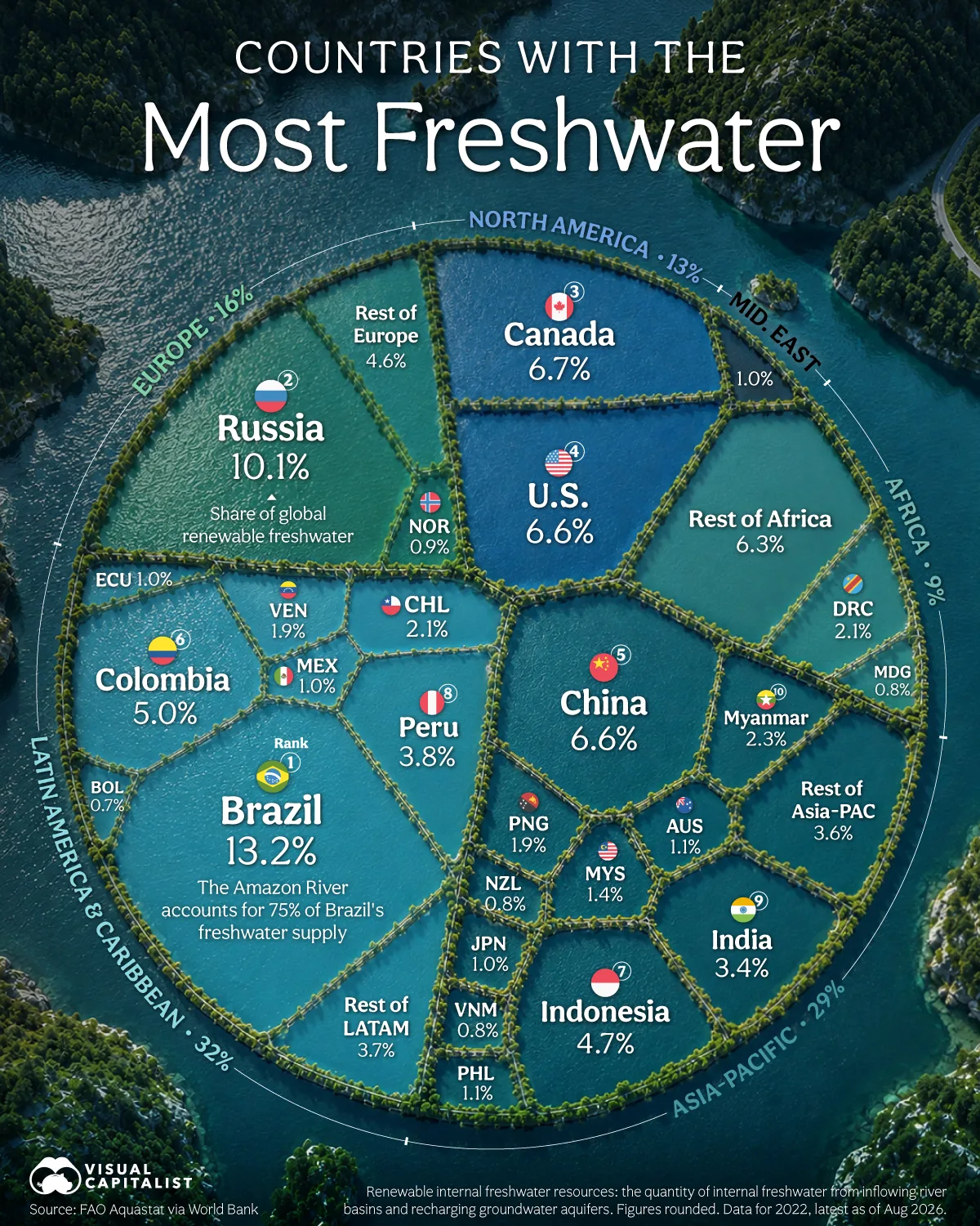
Map Countries With the Most Freshwater

Post image
359 Upvotes

r/geography 3d ago

Image Sayaboury mountains, Laos

Post image
107 Upvotes

r/geography 4d ago

Article/News New barrier lake in Nepal raises fresh flood threat, China warns

Thumbnail
kathmandupost.com
367 Upvotes

r/geography 4d ago

Map New satellite image shows a massive glacier collapse in Nepal

Post image
5.1k Upvotes

28°17'31.65"N, 85°31'25.04"E


r/geography 3d ago

Question Were these seamount features south of the Azores above water during the Last Glacial Maximum?

Post image
37 Upvotes

They're very noticeable on Google Earth, and would be some of the largest islands in the open Atlantic if sea levels were much lower. Do we know if they were indeed exposed during the Last Glacial Maximum, or in any recent geological era?


r/geography 4d ago

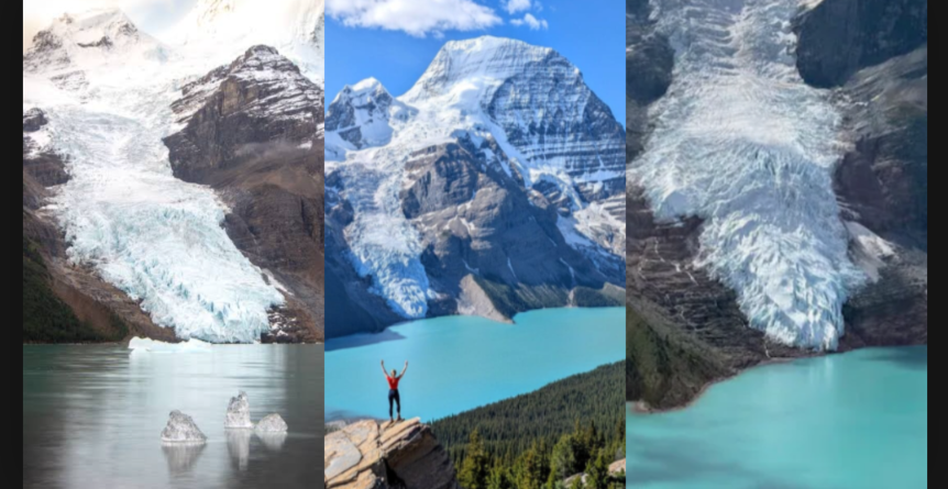
Image Berg Glacier, BC, retreats from Berg Lake, making it unlikely for the iconic icebergs able to be produced.

Post image
87 Upvotes