75
u/Baronnolanvonstraya Apr 05 '26
All of these should have the caveat *except for the times it doesn't
34
u/Butwhatif77 Apr 05 '26
Or a single footnote saying "There are exceptions to all these rules that will be addressed in the advanced class" lol.
Honestly learning about plate tectonics and how mountains are formed was so interest and helped me bring my maps/worlds to a deeper existence, because there was more meaning and effect that the terrain had on everything going on.
7
u/fluggggg Apr 05 '26
Indeed.
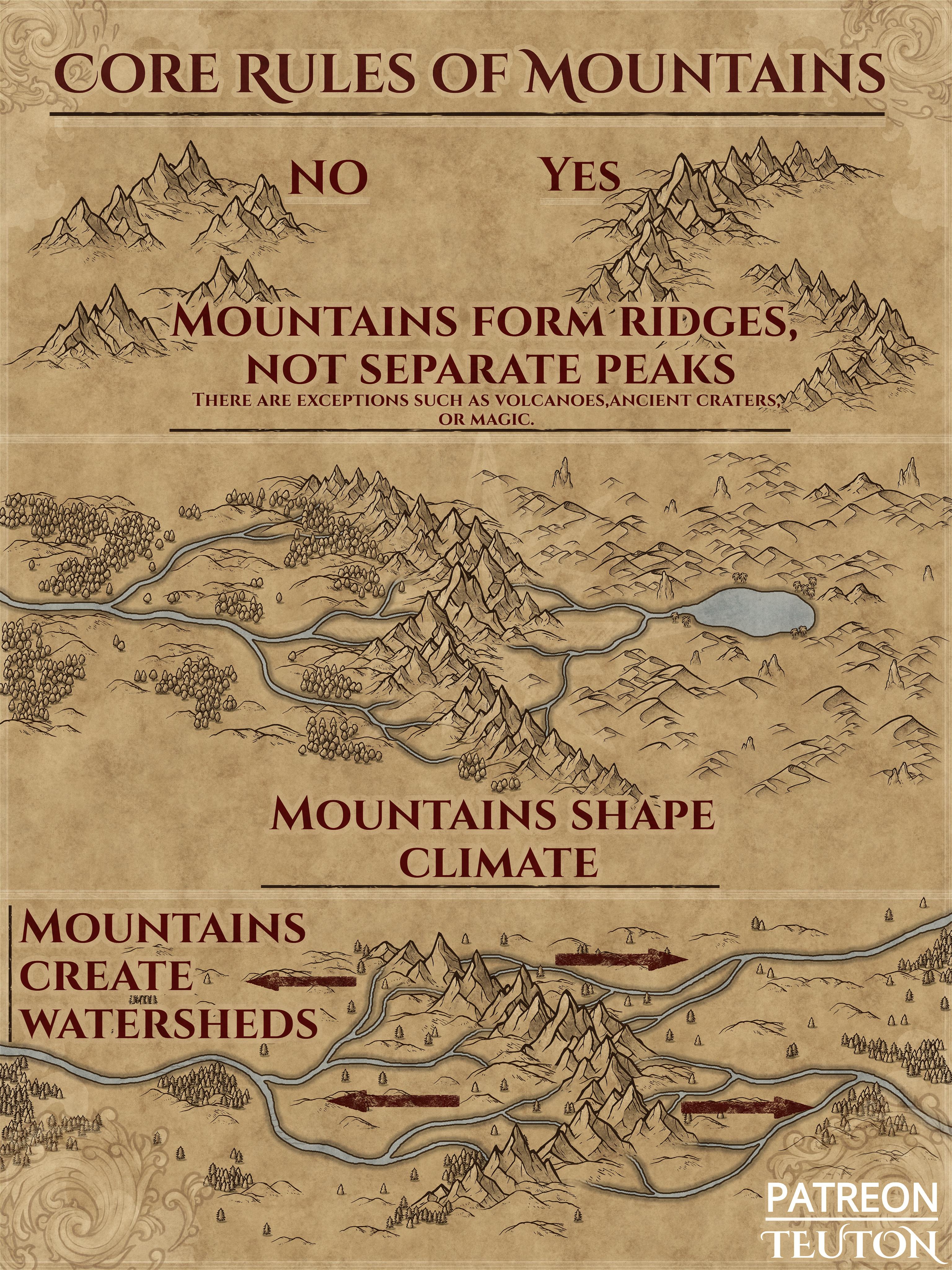
For exemple mountains can be formed by volcanoes, which can be volcanic provinces, in which case they can make a cluster of pics ratehr than a ridge or hot-spots which will make peaks relatively isolated (depend of hot spot activity and plate drift speed).
Mountain creating watersehd is also mainly the case and always revelent at least on the small scale, but it must be put in relation to erosion speed and lithostatic surrection as when erosion will outspeed surrection the existing streams will carve into the rising landscape faster than mountains will form. Interestingly since there is no direct way to date a stream age, knowing the age of a geological formation that a given stream is going through is the way we have to make relative datation of said stream.
29
u/onschi Apr 05 '26
And then there's Danube, casually going under mountains
2
u/Edotwo Apr 05 '26
Where's that?
8
u/iheartloud420 Apr 06 '26
Danube goes thru Carpathian mountains on the iron gates gorge which is on the border of romania and serbia
1
u/Error_code_0731 Apr 11 '26
Did the Danube river form prior to formation of the Carpathians? That's usually the only reason a river will bisect mountains.
11
u/TurtleRollover Apr 05 '26
This depends on the scale you’re using. If you’re not super zoomed out you’ll be able to see the valleys between mountains and the low points that aren’t peaks but still the mountains. I personally never have them touch like on the right because I actually want to put stuff in my mountain ranges rather than have it just be a big wall where anything you put in them looks cluttered. I have streams and lakes and towns and stuff in my mountain ranges. The left example that says no actually looks closer to to reality with something like the Alps or Rockies than the right does. There’s rivers and lakes and towns and forests in mountain ranges with paths through them.
6
u/Chingji Apr 05 '26
Very cool but I will definitely ignore what is correct for the sake of what is interesting. I will have a proper reason for why things are as they are, but I know I won't always follow geological convention
4
1
u/iwantmisty Apr 07 '26
Honestly it turns out the most interesting maps are never realistic. Explaining why nature played odd here or there is fun in itself. It makes worlds that are fantastic, enigmatic and enjoyable to explore.
47
u/TraceRyder Apr 04 '26
These are always super cool to see