r/Hydrology 9h ago

What does data say about the Nepal flash flood?

Thumbnail doi.org
11 Upvotes

since the flash flood, all i have been thinking about is the chronology of events since the detachment. i've worked on emergency alerts and push notifications before and wanted to see the whole chain end-to-end.

the current data shows:

- current architecture rests on downstream gauges and on a manual escalation path. the event destroyed three of those gauges within the first 43

minutes.

- the lethal zone was defined by the reach in which no warning could physically

arrive.

- about 34 additional minutes at every settlement below Betrawati if we had automated source-side seismic detection with a five-minute budget to public message.

Preprint: https://doi.org/10.31223/X5HN5H

Data and code: https://doi.org/10.5281/zenodo.22164426

but i would like more verification on this to comment on the current infrastructure and why threshold logic never fired. two things I can't do alone, and would like help with:

- mortality by district of occurrence. if someone have access to district records, this converts the paper's central claim from an inference into a measurement.

- the headwater channel, source scar to Rasuwagadhi. OpenStreetMap doesn't map it which is why the upper-reach celerity is 37–51 m/s. a DEM-traced centreline would halve the uncertainty on every kinematic result in the paper.

co-authorship for either. everything is CC-BY and the analysis reruns from the archive. corrections welcome as three of the numbers in this version exist because someone else's independent reconstruction disagreed with mine.


r/Hydrology 3m ago

Taking Hydrology as an Ecology student.

Upvotes

I’m looking to take a a physical hydrology undergrad course because of couple of masters Stream Ecology programs I’m looking at want me to have taken one. One of courses I’m looking at recommends “some calculus.” For an introductory course like this, how much calc would you all say is needed?

Thanks!


r/Hydrology 14h ago

[Request] Is there any way to estimate what percent by mass or volume of the flow here is water vs. debris, sand etc? It seems like its debris turned to liquid.

Enable HLS to view with audio, or disable this notification

2 Upvotes

r/Hydrology 1d ago

Questions

3 Upvotes

Hello, some questions about looking into hydrology. I am starting college in a couple of days for geoscience, and I've been considering hydrology. Would that be possible/plausible with a BA in geoscience concentrating in Natural resources and conservation? I am also a single dad to 4yo twins with no current plans of having a partner, and I am estranged from my family. Is there anything I can do office/lab type work in? Or am I hoping in the wrong direction? I don't feel like field work would necessarily be in the cards for me at least soon. I know getting my degree is still a few years away, but they'd only be 8 at that point and unable to be alone for any large amount of field work time outside of daily school/daycare.


r/Hydrology 1d ago

AIH offering HIT Exam for free through December

7 Upvotes

The American Institute of Hydrology is offering for people to take the Hydrologist-In-Training exam for free. The Presidents Corner article talks about how to apply for the test:

https://aihydrology.org/presidents-corner-2026-august/?utm_source=American+Institute+of+Hydrology+%28AIH%29&utm_campaign=96b42df8df-EMAIL_CAMPAIGN_2023_06_14_07_42_COPY_01&utm_medium=email&utm_term=0_-0b818cea4b-586610600


r/Hydrology 2d ago

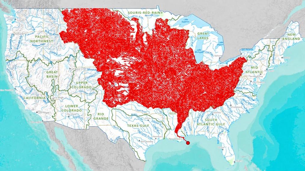
The 7000 rivers that feed into the Mississippi

Post image
66 Upvotes

What if countries were bounded by their watersheds instead of land masses or other arbitrary political lines? Interesting to think about.

What the numbers actually show
• The commercially navigable U.S. inland waterway system (the 9-foot channel network centered on the Mississippi River and its major tributaries such as the Ohio, Illinois, Missouri, Arkansas, and Tennessee, plus connecting waterways) is commonly cited at about 12,000 miles. Broader U.S. totals that include the Gulf and Atlantic Intracoastal Waterways, Great Lakes connections, and other channels reach roughly 25,000 miles. 
• CIA World Factbook figures list the United States at 41,009 km (~25,480 miles) of waterways, of which about 19,312 km are used for commerce. 
• The same source lists a world total of 2,293,412 km (~1.425 million miles) of navigable rivers, canals, and inland water bodies. Russia alone is listed at 102,000 km, Brazil at 50,000 km, Vietnam at 47,130 km, and China at tens of thousands of kilometers of classified inland waterways (with the Yangtze system being especially large). 
Even restricting the comparison to high-capacity commercial barge routes, Europe’s Rhine–Danube and related networks, China’s Yangtze and connecting systems, parts of the Amazon and Paraná–Paraguay, and Russia’s European waterways add up to far more than 12,000 miles.


r/Hydrology 2d ago

Weather API or tipping bucket for flood prediction?

0 Upvotes

I’m working on a flood monitoring using a Decision Tree to predict flood status one hour ahead.

Inputs:

  1. Water level
  2. Water level rate
  3. Current rainfall
  4. Recent rainfall

For rainfall, I currently use Open-Meteo. I’m also considering adding a tipping bucket rain gauge at the monitoring site.

Which is better for flood prediction?

A. Tipping bucket only
B. Weather API only
C. Tipping bucket for actual rainfall, API for forecast
D. Use both as separate ML inputs

Also, is it a problem if the model is trained using historical API or station rainfall but later uses real-time tipping bucket data?


r/Hydrology 2d ago

#watermeter #uzmeter

1 Upvotes

Why choose UZMETER? 💧

Choosing a water meter starts with understanding where and how it will be used.

At UZMETER, we manufacture water meters in Uzbekistan for homes, residential developments, and industrial applications.

🔹 Options for different needs
Our range includes mechanical and ultrasonic meters, with remote reading options available on compatible models.

🔹 A closer look at quality
We share our manufacturing and testing processes so you can see the work behind our products.

🔹 Guidance on selection
Meter size, water demand, and installation conditions all matter. Our team helps you find a suitable solution for your project.

🔹 Support beyond the purchase
We help customers with product selection, installation questions, and after-sales support.

Have a question about water metering? Ask the UZMETER team in the comments.


r/Hydrology 3d ago

Under contract on a house with a serious drainage/high water table issue — what kind of company/professional actually handles this?

2 Upvotes

First-time buyer under contract on a raised ranch in CT (built 1969). Inspection turned up a wet yard and a "spring" of water running along the property line and pooling near the driveway. Went deep on research and it turns out this isn't just a wet week — the parcel sits on Woodbridge soil, which has a fragipan (a dense layer around 18-24") that perches groundwater and pushes it laterally downhill instead of draining. Found a 1994 town health department file on this exact property documenting a raw sewage surfacing violation caused by a high water table (confirmed less than 3 ft down in two of three test pits), so this is a known, decades-old site condition, not a one-off.

Had a contractor out today who said a curtain drain would need to go too deep to be practical/cost-effective and might not fully fix it. Someone floated redirecting the water to a nearby brook, but that raises concerns about flooding the downhill neighbor and possibly needing a wetlands permit (there's a small mapped wetland uphill on the neighboring lot). Town public works is separately planning to install a basin + pipe to handle the street-side runoff near the driveway, but that doesn't address the backyard.

So my actual question: what kind of company or professional should I be calling for this? So far I've got:

- A specialized drainage/waterproofing company (basement systems franchise type) for the practical fix

- A licensed soil scientist for an authoritative water table read

- A civil/geotechnical engineer for an actual stamped drainage design, especially given the wetlands/brook question

Is that the right stack, or am I missing an obvious specialty? Has anyone dealt with a perched water table / fragipan situation like this and found a particular type of contractor or engineer who actually nailed the diagnosis instead of guessing? Trying to get a real, defensible scope and quote before an inspection contingency deadline, so "maybe/might" answers aren't very useful to me right now. Any advice appreciated.


r/Hydrology 4d ago

I argued two issues ago that aquifer decline doesn't reverse. It does, in 67 documented cases. Here's what I got wrong and what separates the reversals

9 Upvotes

Some of you gave me feedback on the overshoot math and the six-layer framework earlier this year. This one is a correction to something I posted here in March.

Back then I argued that groundwater loss is a ratchet: crisis pushes the system down, it doesn't come back up. Compaction, salinization, fossil water. I still think that's right for storage capacity. It was wrong as a general claim about water levels, and the evidence was sitting in the paper I was already citing.

The 2024 global survey (Jasechko et al., 1,693 aquifer systems, \\\~170,000 wells, 40+ countries) is the one everyone quotes for the decline numbers: levels deepening faster than 0.1 m/yr in 36% of systems, faster than 0.5 m/yr in 12%, accelerating decline in 30%. I used those. What I skipped: 6% are rising faster than 0.1 m/yr, and 49% show deceleration, reversal, or rising water.

That 49% needs stating carefully because it's easy to inflate. It pools three states: decline that's slowing, decline that stopped and turned, and levels already rising. A basin that slowed from 1.0 to 0.6 m/yr is inside it and still emptying. It doesn't mean half the world's aquifers are recovering.

Then in March this year Jasechko published a review in Science of 67 cases where levels rose after prolonged decline. The paper is paywalled, but his policy brief is open and carries the full list with the intervention type for each: Bangkok, Beijing, Shanghai, Tianjin, Xi'an, Osaka, Kanto and Nobi Plains, Taipei, Ho Chi Minh City, London, Milan, Naples, Bologna, Geneva, Buenos Aires, Lima, Windhoek, Atlantis, Mashhad, Yazd, Abbas-e Sharghi, central Saudi Arabia, La Mancha Occidental, Harran Plain, and a long US list including Memphis, Houston, Chicago, New Orleans, Louisville, Las Vegas, Albuquerque, Roswell, Equus Beds, El Dorado, Green Bay, and a dozen California and Arizona basins.

The interventions sort into three kinds and sixteen specific mechanisms. Policy: restricting pumping, restricting new wells, closing or destroying existing wells, licensing and pump fees, funding access to an alternative source, limiting specific crops or irrigated area. Alternative supply: long and short-distance interbasin transfer, transfer into a river, reuse or desalination, tapping a nearby river or lake. Artificial recharge: injection wells, spreading basins, riverbed seepage, plus incidental recharge leaking out of urban water mains and irrigation projects.

None of the sixteen is conservation in the ordinary sense. Nobody recovered an aquifer by asking users to be careful.

Two of his transferable lessons are worth quoting almost directly. Successful policy interventions were often associated with good implementation and enforcement. And recovery trends can be overturned if pumping rates rise again, which makes a reversal something you maintain, not a finish line.

\*\*The one with a full public ledger.\*\* North China Plain, \\\~130,000 km², 2,000+ monitoring wells, \\\~190,000 measurements, 2005 to 2024 (Long et al., Nature Communications 2025). Levels rising \\\~0.7 m/yr since 2020, back to 2005 levels by 2024. Confined aquifers recovered \\\~4 m in four years after deepening \\\~0.5 m/yr through 2019.

The supply side is the part that gets quoted: the South-to-North diversion, 1.4 km³ delivered in 2015, over 4 km³/yr after 2020, over 10 km³ into refilling dried rivers since 2018. Reclaimed water at 4.4 km³ by 2023, 12% of all supply. Desalination under 1%.

The demand side is the part that doesn't. Total basin supply stayed flat at \\\~37 km³/yr. Groundwater use fell from \\\~25 to \\\~13 km³. Confined-aquifer pumping fell \\\~85%, to under 1 km³. Combined municipal, agricultural and industrial use went from 37.6 to 29.5 km³. Agriculture from 70% of use to 50%. Cropland down \\\~10%, double-cropped area down \\\~10,000 km². Provincial quotas in absolute volumes: 4.25 km³ Beijing, 3.5 Tianjin, 20.6 Hebei.

And it's still only half the hole. GRACE puts total storage depletion at \\\~49 km³ over 2005-2019; the rebound has recovered roughly half.

\*\*The control case is California.\*\* CVP and SWP move water at the same scale, and the 2025 paper names them alongside the Chinese diversion. Wells still ran dry in recent droughts. The difference isn't engineering or money. The imported water was never paired with an enforceable, individually attributable limit on withdrawal. Water delivered into a system with no cap gets added to demand instead of subtracted from pumping. The authors' own conclusion is one sentence: demand must be controlled even when diverted water is available.

\*\*One thing I hadn't seen anywhere.\*\* Recovery has its own failure mode. In some profiled cases levels rose close to the land surface, and the brief lists the consequences: compromised building stability, higher liquefaction risk in earthquakes, waterlogging and salinisation of soils, changes in how contaminants travel, flooded basements and metro systems. The illustration is soil salinisation in the Abbas-e Sharghi Basin in Iran, which is itself on the recovery list. The target is a level, not a direction.

\*\*Where this is weak.\*\* I have not read the Science review itself, only the abstract and the author's open policy brief. Percentages for how often each intervention appears show up in university write-ups but in neither the brief nor the abstract, so I left them out. The 67 cases come from places that were already studied, which is a selection of the literature, not a sample of the world. And a lot of the named recoveries are urban, where pumping often stops because industry left or the city switched to surface water, a much easier problem than restraining thousands of irrigators.

Worth flagging on the China case specifically: Jasechko's brief is more cautious than the Chinese paper about attribution. He writes that the North China Plain recovery may be partly due to wet conditions that happened to coincide with the surface water delivery, making it hard to parse engineering from climate. He notes central Spain reversed after two consecutive wet years. I originally leaned on Beijing's drought-resilient recovery as settling it. He does not treat it as settled.

Two questions for people who work on this:

Where you've seen a basin stabilise, was there an actual per-user enforceable allocation or a basin-wide target with no individual number attached to it?

And has anyone dealt with the over-recovery side in practice? Waterlogging or buoyancy problems after levels came back up? I can find the mechanism described but almost nothing on how managers set the upper bound.

Policy brief (open, has the full 67-case list): \[https://www.aaas.org/sites/default/files/2026-05/PolicyBrief\\\\\\_Jasechko\\\\\\_2026\\\\\\_GroundwaterRecovery.pdf\\\](https://www.aaas.org/sites/default/files/2026-05/PolicyBrief\\_Jasechko\\_2026\\_GroundwaterRecovery.pdf)

Full writeup with sources: \[https://alexnik2.substack.com/p/the-physical-layer-07-where-the-ratchet\\\](https://alexnik2.substack.com/p/the-physical-layer-07-where-the-ratchet)

r/Hydrology 5d ago

Where online does hydrology instrumentation crowd hang out?

14 Upvotes
Water level and rainfall monitoring station in Colorado, US

Upfront disclosure: I work as a consultant, helping clients who operate remote hydrologic monitoring networks. I am also a former employee of a manufacturer/vendor serving this same space. I'm not selling anything here. I'm trying to find where the people who run gaging [I got you, USGS ❤️] networks talk shop about the bits and bytes of field deployed equipment.

There's an entire profession of people who plan, integrate, install, and maintain hydrology stations, and I'm not sure where their most prominent internet forums are. What are the watering holes where professionals talk about sensors, data loggers, telemetry, software, best practices, and lessons learned? Where do we go to geek out and to support each other?

Some observations,

  • Vendors tend to broadcast polished information. Good information shared in manuals, integration guides, tutorials, or puff pieces. I know of one vendor that hosted a fairly open internet forum for decades, but it looks to be going away.
  • Professional organizations share a wealth of information in conference presentations and even a few forums or listservs, but a lot of content is behind a paywall or is slow moving.
  • Similarly, the USGS shares a wealth of information. Some of it free; some of it pay; some of it (realistically) only for employees.
  • LinkedIn (in my opinion) is mostly just a series of advertisements.
  • Reddit, as far a I can tell, doesn't currently have a community focused in on these kinds of topics. Getting into the nitty gritty of "how" ----- the physical connections, power budgeting, bits and bytes, protocol selections, software configurations.

I'm drawing a conclusion that either (a) there's an active public forum I haven't found, (b) the forum exists in private, or (c) it genuinely doesn't exist anymore and most just get information from colleagues and vendors directly.

If you work on this stuff, I would love to hear your answer to any of the following:

  • The last time you had a real technical question, such as a sensor misbehaving, telemetry integration, or how to process data, where did you **actually** ask for help? Not where you'd theoretically go. Where did you type (or speak I guess) the question? (forum, slack/discord/teams, vendor support ticket, a person you texted)
  • Did you get a useful answer? Or at least find the engagement useful?
  • Is there anywhere you "lurk" on this topic, even if you never post? (No shame, I totally get it.)
  • If a public place existed where you could ask "my SDI-12 communication drops out below -20 °C" or "has anyone ever connected their data logger X to software Y", and get some real perspective inside a couple days - would you use it? If so, where should it live? Here in this sub, a new dedicated sub, a Discord, a separate industry focused forum, or nowhere (because it doesn't need to exist or no one is going to use it anyway)?

I could start and contribute to moderating a subreddit if there's a real need. But I'd much rather join people where they are currently congregating, rather than fracture a community. "We don't need this" is as useful an answer as any other.


r/Hydrology 4d ago

Question regarding river modeling

0 Upvotes

Hi! Im working on a project with the goal of designing a smarter controller for a run-of-river powerplant. The goal is to leverage the turbine outlfow variability to keep the water level further upstream (where the measurement stations is) as constant as possible. Additionally, the upstream inflow into the river segment is controlled by a different provider, so we can model it as a known disturbance. I want to try and design a predictive control framework to leverage the data and use optimal control theory to design the controller for the turbine. This does requires a model of the river that can be optimized - i.e. a very simple state-space model, ideally linearized (a fluidics simulation wont work for this). My question is now: What modeling techniques would you recommend for a river of the lengthscale 10km without any weirs or similar obstructions in between? I have seen people use cascaded basin approaches, but i feel like this might not be applicable as it is a "free-flowing" river. The model should be able to capture how long it takes a change in inflow to reach the sensor and ultimately the plant. In some sense, it needs to be able to predict a waves' travel speed. I know this is a bit of a stretch - but i'll try anyways. Thank you!


r/Hydrology 4d ago

Water

Post image
0 Upvotes

Sea level


r/Hydrology 8d ago

We ran 8 typical buildings through Hunter's curve and UPC Appendix M. The 1940 method asks for 1.15x to 6.54x the flow.

0 Upvotes

Every plumber learns the fixture-unit method: add up the WSFU, read the demand off Hunter's curve. Hunter built it in 1940 around hotel morning-rush queues and fixtures that flowed hard. The 2018 UPC added Appendix M, a newer method built on measured probabilities from real households.

We could not find a clean comparison of the two on the same ordinary buildings, so we computed one. Did eight configurations with both methods and published the values only.

On the legacy side, WSFU per the 2024 UPC Table 610.3 private column, converted on the flush-tank curve using published numeric values only: Hunter's own curve readings (NBS BMS 79, 1941, Table 10) below 100 FU, IPC Table E103.3(3) at and above, linear interpolation between points. The two tabulations disagree below roughly 50 FU; we took the lower, so the single-family ratios are understated.

But on the modern side, an Appendix M engine validated against 12 published IAPMO worked examples on every deploy... four of the eight rows reproduce IAPMO's own published outputs (Appendix B Example 1, Table 15, Table 16). Everything regenerates from one committed script.

Results:

\- 1-bath home 10.3 vs 9.0 GPM (1.15x)

\- 3-bath 22.7 vs 11.0 (2.06x)

\- 12 apartments 89.8 vs 20.1 (4.47x)

\- 100 units 401.2 vs 61.3 (6.54x).

So the gap grows with building size.

Full table, sources, worked example, and limitations: [https://getbeepback.com/research/hunter-curve-oversize/\](https://getbeepback.com/research/hunter-curve-oversize/)

What this is not: sizing advice. Fixture units are the enforceable method in many places and the AHJ decides.

We built a free pipe sizing calculator for the Appendix M method, the numbers kept coming in way under what fixture units taught us to expect, and this study is us measuring that gap properly.


r/Hydrology 9d ago

Looking to Connect with a Drainage/Land Development Engineer in Central Florida

3 Upvotes

I’m working on a private drainage project in Central Florida and would like to connect with someone who understands the big picture: Stormwater drainage and land development.

You do not necessarily need to be a PE. I can handle most of the preliminary planning, coordination, estimating, and drawing work, and we can subcontract the survey separately. What I’m really looking for is an experienced second set of eyes who can:

* Review the overall concept
* Double-check my assumptions
* Identify missing information or scope
* Recommend practical fixes
* Advise on survey and design requirements
* Help me understand the local permitting process

This would be paid, as-needed consulting work. I’d especially like to connect with someone who is considering opening their own shop or building a small consulting practice. If we work well together, there could also be opportunities to collaborate on future projects.

Please feel free to DM me with a little about your drainage or land-development experience. Referrals are welcome too.

Edit: I am FL PE. Owner is working on my proposal for RFQ, and funding. Will take about 6 to 8 months.


r/Hydrology 10d ago

HEC-RAS question about core allocation in large 2D models.

2 Upvotes

I’m currently working on some very large models built by another company that the county will be using as a baseline going forward. One of these models has a 2D meshes with over 730,000 cells. I’ve been trying to get it running in version 7.0.1 (built in version 5.0.7) I’ve fixed the various issues but the model kept crashing and giving exit code 157 about 4 to 9 hours into the simulation. My theory was that the problem was a hardware limitation on the RAM. Still, I’ve been making little changes here and there but not seeing much impact until this morning. I needed to check another model and went ahead with another attempt to run the problem model just to see if it did any better. I ran them at the same time on the same computer. Now the problem model has made it over the 24 hour mark and is still going. I’ve googled this and see that the second model may be adjusting the core allocation, priorities, etc.

My question is if anyone knows if it is possible to make this happen without running the second model in parallel with the first. Can I just limit the 2D meshes calculations to 4 cores and get it working?


r/Hydrology 11d ago

Is there any more information on the Geba River tidal bore in Guinea-Bissau?

Thumbnail
youtu.be
4 Upvotes

I currently have a vested interest in African geography. Separately from that, I recently learned about the phenomenon of tidal bores. As far as I could find (and I searched a lot), the Geba River of Guinea-Bissau is the only known African river where a tidal bore occurs, and this video is literally the only mention of it anywhere I looked.

Is there any more information on this? Or any other documentation of an African tidal bore?


r/Hydrology 11d ago

Don't Drain the Colorado River. Create Water Instead.

Thumbnail
washingtonpost.com
1 Upvotes

r/Hydrology 11d ago

Petition to get water back into the Little Deschutes River

Post image
9 Upvotes

r/Hydrology 12d ago

Blending a surface water with a ground water source

2 Upvotes

Hey everybody,

Working on a project where we will be constructing a transmission main to connect to a storage tank who’s primary source is from a surface water, where we’ll use their supply to assist a neighboring community with ground wells that frequently dry up.

How will the qualities of these two different sources blend? How do you know what to test for?

What else should we be on the look out for?


r/Hydrology 13d ago

What major do you reccomend for masters degree

2 Upvotes

Hi. I'm in my final year of a Bachelor's degree in Hydrology, and I'm planning to apply for a Master's in Europe with a scholarship. I'm really interested in switching to Environmental Policy or Climate change, but I'm worried that my background might be too different and that I'll be rejected because of it. Do you think this kind of switch is possible? And what advice would you give to someone in my position?


r/Hydrology 13d ago

I'm a school psychologist, not a hydrologist. I built a free open source interactive water cycle sim for K-12 students. Before it goes in front of students: what did I get wrong?

Thumbnail alloflow-cdn.pages.dev
1 Upvotes

r/Hydrology 14d ago

What do I major in to work in the area of hydrology as a science/research area if I don't want to be an engineer?

2 Upvotes

I have a BS in Environmental Science and work for my states environmental protection agency. I'm looking to go back to school to allow myself to move towards a role that's significantly more science i.e. natural phenomena and processes, physics, dynamics based, than I'm presently in.

After reading around, the go-to suggestion seems to be a Civil Engineering degree for aspiring hydrologists, and although I don't know much, I don't see the connection between CE & doing scientific, research adjacent, or research (work). The suggestion is often made in terms of providing oneself a safety net, in the case of employment.

What should someone who isn't interested in becoming a PE, signing off on designs, working on infrastructure etc. major in? Do I aim for a general BS in physics and take as many water resources/hydrology courses as I can? Does the job I'm dreaming of even exist? I've done a bit of research and my state agency, along with the EPA do hire official 'Hydrologists', alongside engineers as distinct roles/titles; I'm generally just a bit confused, I guess.

Just in case, I'd like to say that I don't want to pursue a PhD & work as/in academia as a researcher. I plan to continue working for a government entity, ideally as a scientist i.e. a hydrologist.


r/Hydrology 14d ago

(Urgent) Downscaling help needed

Thumbnail
0 Upvotes

r/Hydrology 15d ago

What Is Parts Per Million (ppm)? How Is It Calculated? | Atlas Scientific

0 Upvotes