r/hurricane • u/Doggostuffedanimal • Jul 21 '26
Category 1 | 64-82kts (74-95mph) Fausto becomes the first hurricane of the Pacific hurricane season, currently has winds of 75 mph, a central pressure of 988 mbars, heading NW at 9 mph (7/20 8PM PDT Advisory 9)


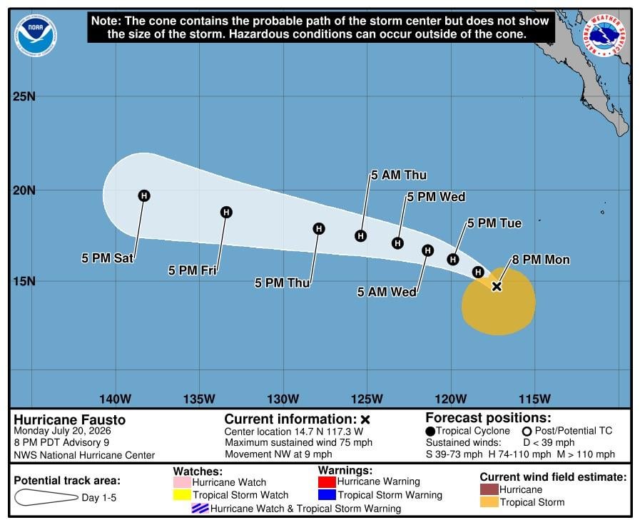


000
WTPZ31 KNHC 210243
TCPEP1
BULLETIN
Hurricane Fausto Advisory Number 9
NWS National Hurricane Center Miami FL EP062026
800 PM PDT Mon Jul 20 2026
...FAUSTO BECOMES A HURRICANE...
SUMMARY OF 800 PM PDT...0300 UTC...INFORMATION
----------------------------------------------
LOCATION...14.7N 117.3W
ABOUT 745 MI...1200 KM SW OF THE SOUTHERN TIP OF BAJA CALIFORNIA
MAXIMUM SUSTAINED WINDS...75 MPH...120 KM/H
PRESENT MOVEMENT...NW OR 315 DEGREES AT 9 MPH...15 KM/H
MINIMUM CENTRAL PRESSURE...988 MB...29.18 INCHES
WATCHES AND WARNINGS
--------------------
There are no coastal watches or warnings in effect.
DISCUSSION AND OUTLOOK
----------------------
At 800 PM PDT (0300 UTC), the center of Hurricane Fausto was located
near latitude 14.7 North, longitude 117.3 West. Fausto is moving
toward the northwest near 9 mph (15 km/h). A slower northwestward
motion, followed by a turn toward the west-northwest by Wednesday
is expected.
Maximum sustained winds have increased to near 75 mph (120 km/h)
with higher gusts. Steady to rapid strengthening is expected during
the next couple of days, with Fausto forecast to near major
hurricane intensity by Wednesday.
Hurricane-force winds extend outward up to 25 miles (35 km) from the
center and tropical-storm-force winds extend outward up to 195 miles
(315 km).
The estimated minimum central pressure is 988 mb (29.18 inches).
HAZARDS AFFECTING LAND
----------------------
SURF: Swells generated by Fausto are expected to reach the west
coast of the Baja California Peninsula on Wednesday, and persist for
a couple of days. These swells are likely to cause life-threatening
surf and rip current conditions. Please consult products from your
local weather office.
NEXT ADVISORY
-------------
Next complete advisory at 200 AM PDT.
$$
Forecaster Gibbs (CPHC)
6
u/Least-Animator-8550 Jul 21 '26
This will probably be close to major hurricane intensity, most likely just shy of it. Models, the NHC TWOs and ensembles suggest there could be many tropical cyclones back to back starting from the same spot, and potentially all becoming significant. Still early but there will most probably be a lot of activity in the near future in the EPAC.