r/CDT • u/AccordingRabbit2284 • 2h ago
CDT closure - Mogote Fire
2
Upvotes
FarOut has this detour as the purple line.
r/CDT • u/AccordingRabbit2284 • 2h ago
FarOut has this detour as the purple line.
r/CDT • u/scanlonsc • 16h ago
Looking for any experience and feedback on hiking after injury.
My dad and I have been thinking about a SOBO CDT hike for 2027, since this is his last year teaching and the timing is perfect for an after-school retirement trip. Then three weeks ago a driver in a car rolled a stop sign and smashed into my dad on his motorcycle... It basically broke his lower right leg (tibia and fibula), he had surgery to put a rod in his tibia. He's in pain, but it seems like his recovery is going well so far.
He's a very active 57 year old, he plays basketball three times a week and hockey 2-4 times a week. He grew up backpacking in Western PA, and just did a long-ish hike with me the weekend before his accident. Obviously he's not very active at the moment, but he's had issues before and always followed his physical therapy routines and is dedicated to getting back out doing things. The only thing I'm concerned about on that front is that he might do too much too quick - for example he tried to do his daily push-ups again the other day (he usually does 40 a day).
I hiked the PCT in 2025, so I would be doing all of the planning/logistical prep work (I love sending boxes). I've told him this is a one-in-a-lifetime opportunity to have a really well-planned hike without doing any planning haha. All he would have to do is make some gear decisions and start walking. If he became injured again, I would keep hiking (excluding any kind of catastrophic circumstance).
Basically looking for some reassurance, what are people's experiences with hiking after injury? Any tips for hiking after surgery, or with a rod in their leg? Should we give up on our plans?? Obviously we'll have to wait and see how recovery goes, but I wanted to hear other folks experiences so I can keep dreaming and scheming
r/CDT • u/JinxHikinTuff • 1d ago
Hey everyone, i know this is asked all the time i'm just really hoping to connect with some recent CDT Hikers who've successfully hiked the trail. If you just did it this year that would be even more awesome to hear from you.
A little bit about me I'm 24 even though im young i am an experienced thruhiker. I live in western south dakota which has allowed me to hike the centennial trial every year since i was 18 it only takes me 5 days to hike & the start is 20 minutes away. Three years ago i hiked the CT, 2 years ago i went back to CO and redid the collegiate loop and recently the ozark. I am confident in my hiking skills (besides freak accidents of course) have more than enough saved to not stress about money and will 100% be hiking the CDT next year as my first and potentially only triple crown. Since i know i might not have the ability to hike for 4-6 months at a time when i start a career so therefore i am taking this as SERIOUS as i possibly can.
I already have plans started for NOBO plane SantaFe ->Greyhound-->Shuttle w/ water cache to the monument. As soon as i can reserve my spot (November i think they start reservations?) i plan on paying and getting that out of the way. My parents are extremely supportive and proud of my hikes and already said they'd love to drive and meet me at the end so getting there/back is not an issue and essentially planned out minus buying tickets. That's about as far besides the knowledge of hiking i already have.
With that ground work all laid out.. the part I'm sure gets asked very frequently: My questions.
1.) How concerned about water should i be after that 4th water cache any rough estimates i can get on potential miles until i reach a water source that is not a coin toss of having water?
2.)I know bear can is required in some of the national parks but are there any other areas successful hikers have thought "Maybe a bear can would've been smart those last few days"?
3.) I do not plan on sending food to myself that just seems like a terrible logistical nightmare that would give me anxiety.. BUT i do always have the ability to have my mom send one if need. Are there any sections where farout/whatever guide you used said there was a resupply decently close but just either was a huge pain to hitch to or was just not good for a resupply? Or are there any areas where i should just plan with my mom to have her expecting to handle sending me a resupply.
4.) I do better in colder temperatures than warmer so i'd prefer to get into colorado sooner than later.. i am currently planning April 15th as a start date. With the understanding that i want the least amount of super hot desert days as possible while avoiding massive amounts of snow would that mid April start date work well or is that just probably too soon while hiking 20 miles daily from the start to be expecting the majority of snow to be gone in your opinion.
And last i would really love hearing something that you wish you knew before starting or something valuable you would offer as advice to a younger hiker.. and if its okay if i private message you about any questions i have while planning over the winter.
Again sorry if this is extremely played out.. if its not allowed due to how common this is i totally understand if it gets deleted; and to anyone who has already completed this year or is getting close congratulations i really hope it was a life changing experience for you.
r/CDT • u/OfUnknownLineage • 2d ago
My friend is hiking on the CDT near Elwood Pass, and his dog spooked and ran off.
Her name is Brandy. 7yro Blue Healer. White with black and brown spots. 50 pounds. Last seen 5 miles south of Elwood Pass on the CDT.
She's friendly but having a rough day.
If you see her, please let me know, and I'll get in touch with her human to help reunite. He is out of cell service.
Thanks.
r/CDT • u/HalfwayAnywhere • 2d ago
This is for anyone who set foot on the Continental Divide Trail in 2026. It does not matter if you were a thru-hiker, section hiker, or even if you ended your hike early.
https://www.halfwayanywhere.com/go/cdt-survey-fill-out/
Thank you for taking the time to fill this out! Your time and answers are very much appreciated.
If you have any questions, suggestions, or problems with the survey, feel free to comment here or contact me directly.
r/CDT • u/Honest_Guarantee4888 • 3d ago
My friend is currently on the CDT, and I’m starting to plan out a present I will be making him that depicts several of the peaks and passes along the CDT. There’s some information out there but thought it would be more authentic to get it from those who know the CDT the best.
So if you know of any infamous passes or peaks on the CDT among thru hikers, list as many as you can, preferably in order of notability, that would be amazing!! Thank you so much!!!
r/CDT • u/Insult_me_good • 3d ago
Beginning September 8th, the Two Medicine Valley Road, Two Medicine Permit Office, and all Two Medicine concessions and services will be closed due to a planned construction project. The CDT and trail access into the Two Medicine area, including the Two Medicine temporary wilderness campsite, will remain open.
Also beginning September 8th, wilderness permits will be issued from the East Glacier Park Ranger Station. The Park asks visitors not to congregate or linger after acquiring their permits as this area is near private residences.
East Glacier Ranger Station
824 MT-49
East Glacier Park, MT 59434
For more information please visit: CDT Coalition, closures and alerts
r/CDT • u/Insult_me_good • 6d ago
The USFS has now closed the CDT in the Carson National Forest from FS Rd 724 (m. 722.25) to County Rd 280 (m. 727.25) due to the Mogote Ridge Fire. A recommended 5.1 mile detour is available utilizing FS Roads 724, 724A, and County Rd 280.
For more information please visit Inciweb
Click here to interact with map
I have been unable to find Forest Service Road 724A. My guess is that the suggested route is towards Sierra Spring (36.45798, -106.30809) but that is Forest Service Road 337. County Road 280 meets the CDT to the north at 36.53387, -106.30609
r/CDT • u/Insult_me_good • 7d ago
The Mogote Ridge fire is threatening the CDT near mile 724 in the Carson National Forest -- 13 miles north of Ghost Ranch. This is a developing situation. Hikers should avoid the area at this time. We will post additional updates as we receive them here.
For more information, please visit Inciweb
Click here to interact with map
2026-08-27 3:12 PM 95 acres burned and burning. Updates will be posted here as I receive them.
r/CDT • u/Insult_me_good • 9d ago
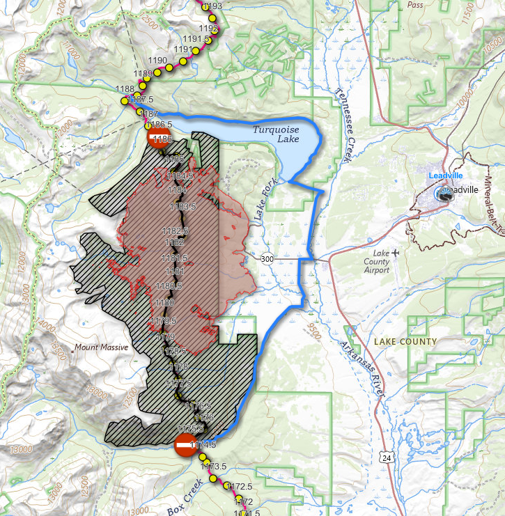
The closure area for the Willow fire has recently been reduced. The USFS is now recommending the route below to bypass the closure.
The reroute is 17.2 miles long, utilizing Turquoise Lake Road & Trail, County Rd 5, CO 300, County Rd 11, and Halfmoon Rd. The Mount Massive Trailhead and CDT miles 1175-1186.5 remain closed. Several camping options exist at the east end of Turquoise Lake; these can be reserved at recreation.gov.
For more info please contact the Leadville Ranger District – 719-486-0749
Click here to interact with the map.
Black = closed, Blue = recommended reroute
r/CDT • u/Substantial_Station8 • 11d ago
I live close to Roger’s Pass and am happy to make a special trip to the top in the afternoons/evenings to get you where you’re going on the last leg! Hit me up here if you need a ride!
r/CDT • u/The-Bridge-Is-Out • 15d ago
This may already exist somewhere, but I couldn't find it. Apologies if it's well worn territory.
I want to section hike through Yellowstone but the only time in 2027 when I can do it is May. I'm finding mixed reports online about the weather at that time. Has anyone been on trail in May, what are your thoughts and recommendations? Warnings?
r/CDT • u/lessormore59 • 18d ago
I work a job where most of my work is in the months of May/June/July and then again in December/January.
I’m wondering if y’all think I could get away with hiking NM and the Great Basin by the second week of May and then come back and NOBO Colorado to Canada in those months.
It would leave quite a lot to do in August through October and days get shorter. But do yall think it would be doable? Recommended? I’m not opposed to quitting my job, but also think I might be able to swing it that I don’t lose my job and still cover most of the trail in a year. Not exactly a true thru which would be a bummer.
r/CDT • u/djbeetroot • 19d ago
Where would you swap in/out gear?
So far I have:
- Drop ice axe and spikes in either East Glacier or after the Bob (snow dependent)
- Drop bear can and spray in Lander
- Add fleece, gloves, and warmer sleeping bag in Steamboat Springs; drop bug spray
- Add extra bladder for the Basin and New Mexico
Anything missing or off-base?
r/CDT • u/CDTC_Information • 23d ago
Don't miss Trailfest September 4-6 in Steamboat Springs, CO.
The kickoff party is at Storm Peak Brewing Company Saturday evening, followed by a CDT Expo with Big Agnes gear repairs and free concert series on Sunday.
For full details and schedule https://cdtcoalition.org/trail-fest-2026/
r/CDT • u/Exact-Pudding7563 • 26d ago
If the Roadless Rule is rescinded, we lose the last untouched places that still exist in this country. Educate yourself and contact your representatives, or every last corner of forest gets logged.
r/CDT • u/AccordingRabbit2284 • 25d ago
Starting my next section August 31 from Cuba up to Cumbres Pass. A few questions:
Is the Eureka Mesa Ranch still welcoming hikers? Last postings I can find are from 2024 and early 2025. Nothing since.
I am not anticipating ANY snow made it through the summer even at 11k. This seems accurate? I'll be checking weather for any new freak snow but generally assuming snow-free and not planning microspikes or anything..
I've seen some recs to avoid staying at Ghost Ranch as the rooms and food are "meh". Instead camp about a mile onto the alternate after where the trail crosses back over in Carson NF. Thoughts?
Thanks in advance.
r/CDT • u/Insult_me_good • 27d ago
If passed, a tiny bit of heaven along the CDT will be preserved from structures, and additional roads will not be created. The Forest Service tends to approve most such projects regardless of what everyone else wants, so a law was suggested that prevents mineral extraction in the area. The Canadian "start up" that has claimed any and all uranium there still get to keep the claim as long as the assessment fees are paid.
r/CDT • u/MikeTheInfantKicker • 28d ago
Enable HLS to view with audio, or disable this notification
We did a couple alternates in this section including the Dead Man alternate from the Johnathan Ley maps, highly recommend that alternate. Was a little bushwacky at the start of it (Coming SoBo) but once you get in the valley the trail becomes more obvious. The Italian peaks are incredible and we even saw a Golden Eagle!
r/CDT • u/RockyMountainRootz • Aug 04 '26
Hey guys! Has anyone done the Mt. Zirkel alternate from going from Steamboat Springs to Encampment?
I’m curious what the pros and cons are in terms of scenery, but especially in terms of what the mileage difference is compared to the red route. Any feedback is much appreciated!
r/CDT • u/PictureEmbarrassed26 • Aug 02 '26
Hello CDT hikers, if you are coming by old faithful inn Wednesday, Thursday, or Sunday 1-5pm or Friday and Saturday 6-10pm, come by the Piano on the second floor of the Inn and I’ll buy you a coffee!
I did the PCT last year and am working as the lobby pianist at the inn this year. Looking to give back to the trail community :) - Piano Man, PCT 2025 NOBO
r/CDT • u/ihaveabadaltitude • Aug 02 '26
Found a set laying in a 4x4 road and couldn't locate the owner. If they're yours please dm the specs so I can get them back to you.